Satellite image three-dimensional area network adjustment method based on satellite-borne laser height measurement data

A technology of regional network adjustment and satellite imagery, which is applied in the field of satellite remote sensing image adjustment, and can solve the problems of insufficient elevation measurement accuracy of ZY-3 surveying and mapping satellites.

Active Publication Date: 2015-09-23
SATELLITE SURVEYING & MAPPING APPL CENTSASMAC NAT ADMINISTATION OF SURVEYING MAPPING & GEOINFORMATION OF CHINANASG
View PDF5 Cites 57 Cited by
  • Summary
  • Abstract
  • Description
  • Claims
  • Application Information

AI Technical Summary

Problems solved by technology

Chinese patent application 201310143369.3 discloses a multi-source heterogeneous remote sensing image control point automatic acquisition method, which can automatically extract remote sensing control image points (control point image films) from multi-source heterogeneous images, improving the efficiency and accuracy of control data acquisition. But in essence, it is still an automatic acquisition method of plane control points.
However, since this method is only for image plane block adjustment, it cannot solve the problem of insufficient elevation measurement accuracy of ZY-3 surveying and mapping satellite

Method used


Image

  • Satellite image three-dimensional area network adjustment method based on satellite-borne laser height measurement data
  • Satellite image three-dimensional area network adjustment method based on satellite-borne laser height measurement data
  • Satellite image three-dimensional area network adjustment method based on satellite-borne laser height measurement data

Examples


Embodiment Construction

[0043] In order to make the purpose, technical solutions and advantages of the embodiments of the present invention more clear, the following will clearly and completely describe the technical solutions of the embodiments of the present invention in conjunction with the drawings of the embodiments of the present invention. Apparently, the described embodiments are some, not all, embodiments of the present invention. Based on the described embodiments of the present invention, all other embodiments obtained by persons of ordinary skill in the art without creative efforts shall fall within the protection scope of the present invention.

[0044] Unless otherwise defined, the technical terms or scientific terms used herein shall have the usual meanings understood by those skilled in the art to which the present invention belongs. "First", "second" and similar words used in the patent application specification and claims of the present invention do not indicate any order, quantity ...


PUM


Abstract

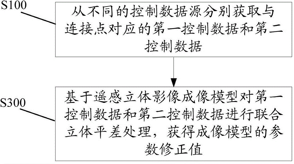
The invention relates to a satellite image three-dimensional area network adjustment method based on satellite-borne laser height measurement data. The method comprises the following steps: respectively acquiring first control data and second control data corresponding to a connection point from a first control data source and a second control source; carrying out combined three-dimensional adjustment treatment for the first control data and second control data on the basis of a remote-sensing three-dimensional imaging model, acquiring a parameter correction value of the remote-sensing three-dimensional imaging model, wherein acquiring the first control data and the second control data includes acquiring a plane coordinate of the satellite-borne laser height measurement data; mapping the plane coordinate of the satellite-borne laser height measurement data to a satellite remote-sensing digital orthographic image, and acquiring a footprint image; forming second control data by the satellite-borne laser height measurement data and the footprint image or partial plane control data of the footprint image; acquiring homonymy points of a given quantity in the range of the footprint image or part of the footprint image as connection points, and using the control data of the homonymy points as first control data.

Description

technical field [0001] The invention relates to a satellite remote sensing image adjustment method, in particular to a satellite image three-dimensional area network adjustment method based on space-borne laser altimetry data. Background technique [0002] With the development of economy, 3D geographic information has been widely used in digital earth, urban planning, environmental protection and other aspects. With the rapid development of remote sensing satellite technology, aerospace photogrammetry has become another means of quickly obtaining 3D geographic information after aerial photogrammetry. Great progress has been made. [0003] For example, Ziyuan-3 is my country's first high-precision civil stereoscopic mapping satellite. Its successful launch and effective application broke my country's long-term dependence on foreign high-precision satellite images, and produced huge social and economic benefits. However, due to the optical stereo satellite stereo mapping met...

Claims


Application Information

Patent Timeline
Patent Type & Authority Applications(China)
IPC IPC(8): G01C11/00
CPCG01C11/00
Inventor 唐新明李国元王华斌张重阳高小明崔成玲
Owner SATELLITE SURVEYING & MAPPING APPL CENTSASMAC NAT ADMINISTATION OF SURVEYING MAPPING & GEOINFORMATION OF CHINANASG
Why Eureka
Try Eureka