Fine method for global vegetation classification based on multi-temporal remote sensing data and spectroscopic data

A technology of remote sensing data and spectral data, applied in the fields of instruments, character and pattern recognition, computer parts, etc., it can solve the problems of inability to obtain fine vegetation classification products quickly and on demand, low temporal resolution, and poor universality. Market prospects and application value, the effect of improving efficiency and accuracy, and ensuring reliability

Inactive Publication Date: 2015-10-28
INST OF REMOTE SENSING & DIGITAL EARTH CHINESE ACADEMY OF SCI
View PDF2 Cites 21 Cited by
  • Summary
  • Abstract
  • Description
  • Claims
  • Application Information

AI Technical Summary

Problems solved by technology

[0010] The invention provides a global fine vegetation classification method based on multi-temporal remote sensing data and spectral data, which is used to solve the problem of poor universality of classification algorithms in different regions of the world caused by the existing vegetation cla

Method used


Image

  • Fine method for global vegetation classification based on multi-temporal remote sensing data and spectroscopic data
  • Fine method for global vegetation classification based on multi-temporal remote sensing data and spectroscopic data
  • Fine method for global vegetation classification based on multi-temporal remote sensing data and spectroscopic data

Examples


Example Embodiment

[0030] In order to better understand the technical solutions of the present invention, the present invention will be described in detail below with reference to the drawings and specific embodiments.

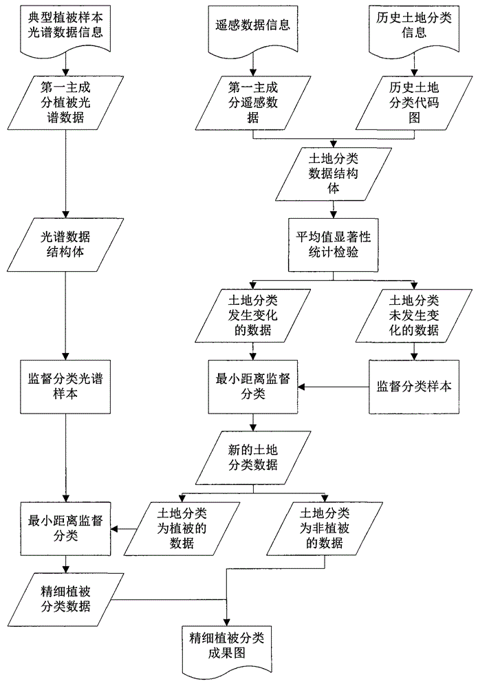
[0031] The present invention is a global fine vegetation classification method based on multi-temporal remote sensing data and spectral data. The method mainly includes the following steps:

[0032] 1. Acquisition of remote sensing data and typical vegetation spectrum data;

[0033] 2. Remote sensing data and spectral data preprocessing;

[0034] 3. Feature information extraction;
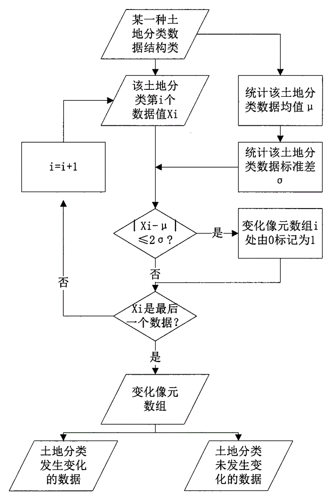
[0035] 4. Statistical test of the significance of the mean value changes the land type;

[0036] 5. Use land type change information to classify land;

[0037] 6. Use spectral data information for fine vegetation classification.

[0038] The specific implementation process of the present invention is as follows figure 1 As shown, the specific implementation details of each part are as follows:

[0039] 1. Remote s...


PUM


Abstract

Provided is a fine method for global vegetation classification. The method comprises: firstly, obtaining spectroscopic data and remote sensing data of vegetation with a first main component; secondly, obtaining an area where land classification changes through the remarkable statistical test of average values; thirdly, performing minimum range monitoring classification of the area where land classification changes by taking an area where land classification doesn't change as a monitoring classification sample; fourthly, performing minimum range monitoring classification of a vegetation part of obtained data of new land classification data by utilizing spectroscopic data to obtain fine vegetation classification data; and finally, combining the obtained fine vegetation classification data with the non-vegetation data to obtain a fine vegetation classification result map. The method is applicable to departments of territorial resources, agriculture, forestry, and the like for fast updating a huge amount of land and vegetation classification data, and for fast accurately monitoring condition of vegetation growth and situation of change of land use.

Description

technical field [0001] A global fine vegetation classification method based on multi-temporal remote sensing data and spectral data belongs to the field of digital image processing, and particularly relates to vegetation coverage type change detection technology and digital image processing technology. Background technique [0002] Vegetation coverage type refers to the surface vegetation coverage formed due to the natural attributes of the land or affected by human activities, such as forests, grasslands, crops, bare land, etc. Fine vegetation classification is a more detailed description of vegetation coverage types, such as subdividing forest coverage types into deciduous broad-leaved forests and evergreen coniferous forests, and subdividing crop types into rice, wheat, corn, etc. . Fine vegetation classification is an important part of land classification research. Changes in vegetation types largely affect changes in other properties of the earth system, such as ecosys...

Claims


Application Information

Patent Timeline
IPC IPC(8): G06K9/62
Inventor 康峻高帅牛铮占玉林贾坤
Owner INST OF REMOTE SENSING & DIGITAL EARTH CHINESE ACADEMY OF SCI
Why Eureka
Try Eureka