BeiDou based ground-based navigation signal networking system

A navigation signal and ground-based technology, applied in the field of satellite navigation, can solve problems such as limiting the service performance of satellite navigation systems, and achieve the effects of improving spatial geometric distribution, realizing compatible interoperable reception, and reducing PDOP value.

Inactive Publication Date: 2015-11-25
TRAFFIC INFORMATION COMM TECH RES & DEV CENT +1
View PDF4 Cites 27 Cited by
  • Summary
  • Abstract
  • Description
  • Claims
  • Application Information

AI Technical Summary

Problems solved by technology

This limits the service performance provided by the satellite navigation system to a certain extent

Method used


Image

  • BeiDou based ground-based navigation signal networking system
  • BeiDou based ground-based navigation signal networking system
  • BeiDou based ground-based navigation signal networking system

Examples


Embodiment Construction

[0036] The embodiments will be described in detail below in conjunction with the accompanying drawings.

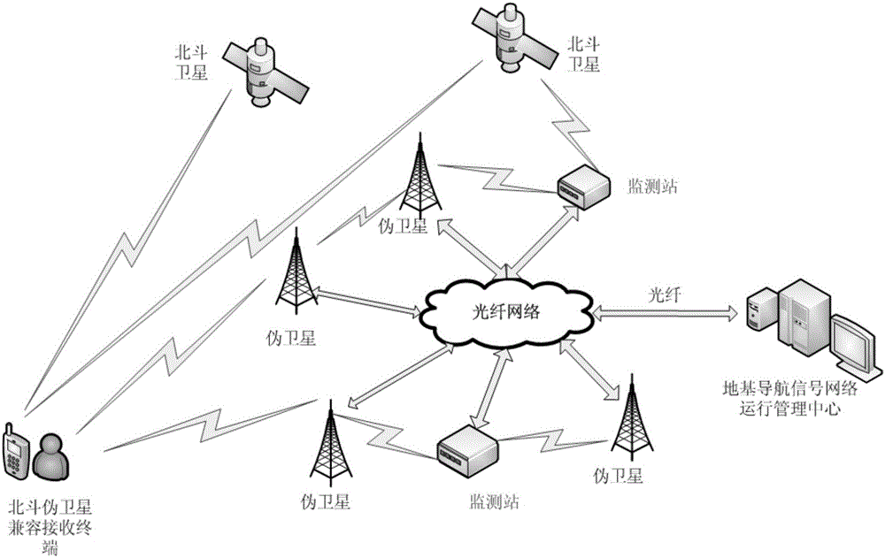
[0037] Within the management scope of a certain regional ground-based navigation signal network, the ground-based navigation signal network operation management center is responsible for the management and control of all pseudolites within the jurisdiction. The ground-based navigation signal network operation management center gathers various data and states of pseudolites and monitoring stations in the ground-based navigation network, conducts comprehensive processing, and generates various control commands and data. The ground-based navigation signal network operation management center is responsible for information processing and task coordination of the entire ground-based navigation signal network, collecting observation data and working condition information of all ground monitoring stations, calculating system integrity, availability, and generation of pseudolite eph...


PUM


Abstract

The invention belongs to the technical field of satellite navigations, more particularly to a BeiDou based ground-based navigation signal networking system, which comprises ground based pseudolites, ground based monitoring stations, BeiDou pseudolite compatible receiving terminals, and ground based navigation network operation and management centers. The psuedolites, together with the various ground based monitoring stations, form an optical fiber network. And through the optical fiber network, the psuedolites are connected with the ground based navigation network operation and management centers. The ground based psudolites broadcast ground based navigation signals and telegram texts. The ground based monitoring stations monitor completeness of signals from the psudolites, calculate the time difference between the psudolites and upload information to the ground based navigation network operation and management centers. The ground based navigation network operation and management centers conduct uniform calculations on time synchronizing information and transmit the completeness and the time information to psudolites through the optical fiber network. The BeiDou pseudolite compatible receiving terminals finally complete the position calculation for independent positioning and cooperative positioning.

Description

technical field [0001] The invention belongs to the technical field of satellite navigation, in particular to a Beidou-based ground-based navigation signal network system. Background technique [0002] Satellite navigation systems are widely used in global service industries and military fields. However, since satellites are orbiting at a height of about 20,000km from the ground, the satellite navigation signals received by ground users are very weak, which sometimes leads to poor signal stability and even failure to receive satellite signals. This limits the service performance provided by the satellite navigation system to a certain extent. The use of the ground-based pseudolite navigation system can significantly improve the performance of the satellite navigation system. However, the regional ground-based augmentation technology based on my country's Beidou satellite navigation system is still in its infancy. There are few related studies, and it is basically blank. How...

Claims


Application Information

Patent Timeline
Patent Type & Authority Applications(China)
IPC IPC(8): G01S19/46G01S19/11
CPCG01S19/46G01S19/11
Inventor 卢红洋沈兵李晶于渊周子麟
Owner TRAFFIC INFORMATION COMM TECH RES & DEV CENT
Why Eureka
Try Eureka