High-precision map data processing method and high-precision map data processing device

A technology of map data and processing methods, applied in image data processing, special data processing applications, geographic information databases, etc., can solve problems such as ghosting and dislocation of map image objects, and achieve the effect of removing ghosting and improving clarity

Active Publication Date: 2016-01-20
BAIDU ONLINE NETWORK TECH (BEIJIBG) CO LTD
View PDF3 Cites 47 Cited by
  • Summary
  • Abstract
  • Description
  • Claims
  • Application Information

AI Technical Summary

Problems solved by technology

[0009] In view of this, the embodiments of the present invention provide a method and device for processing high-precision map data, so as to solve the problems of dislocation and ghosting of objects in map images that occur when correlating image data collected multiple times

Method used


Image

  • High-precision map data processing method and high-precision map data processing device
  • High-precision map data processing method and high-precision map data processing device
  • High-precision map data processing method and high-precision map data processing device

Examples


Embodiment 1

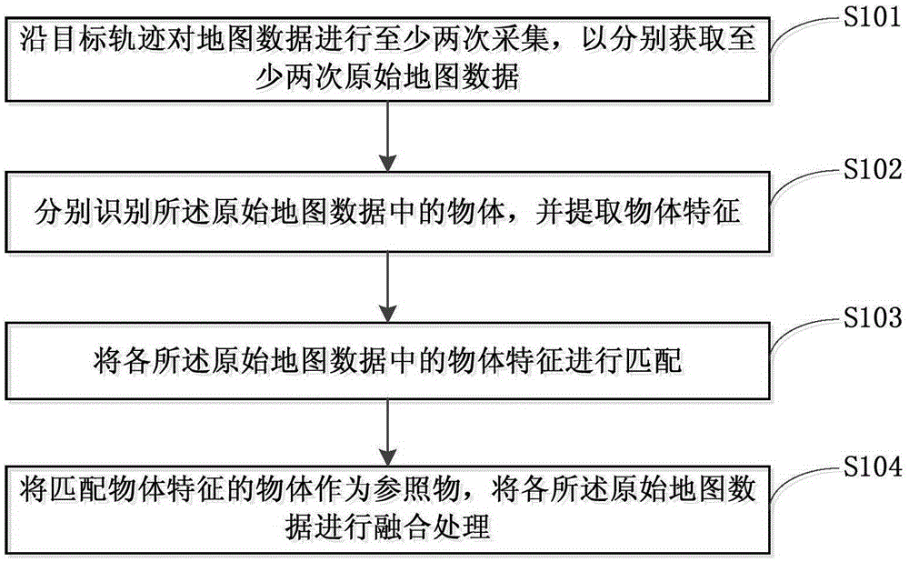
[0026] figure 1 It is a flow chart of a method for processing high-precision map data provided by Embodiment 1 of the present invention. The method can be executed by a device for processing high-precision map data, wherein the device can be implemented by software and / or hardware, and can generally be integrated into a server capable of processing image data.

[0027] see figure 1 , the method specifically includes the following:

[0028] S101. Collect map data at least twice along the target trajectory, so as to obtain at least two original map data respectively.

[0029] In the above operations, the target trajectory may refer to the collection route of collection tools such as a collection vehicle for map data collection, a collection aircraft model, or a collection robot. The route may be artificially preset and stored in the above collection tool. It may also be a better collection route determined by the collection tool itself according to the collection start point ...

Embodiment 2

[0051] The method for processing high-precision map data provided by Embodiment 2 of the present invention is based on the above-mentioned embodiments. Further, the method for separately identifying objects in the original map data and extracting object features is optimized. The optimization is to use Static object recognition is performed on the point cloud data in the original map data, and structural features of the static object are extracted.

[0052] Point cloud data includes the reflectivity and shape features of different objects. Since point cloud data is a series of discrete points of the surface model of object data, compared with using image data to identify objects, using point cloud data to identify static objects can improve the accuracy of identifying objects, thereby improving the extracted Accuracy of object features.

[0053] Optionally, on the basis of the technical solutions of the above-mentioned embodiments, the reflectance in the point cloud data in t...

Embodiment 3

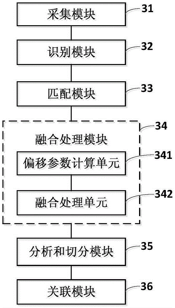
[0065] image 3 It is a schematic structural diagram of an apparatus for processing high-precision map data provided by Embodiment 3 of the present invention.

[0066] see image 3 , the device of this embodiment specifically includes: an acquisition module 31, an identification module 32, a matching module 33 and a fusion processing module 34;

[0067] Wherein, the collection module 31 is used to collect the map data at least twice along the target trajectory, so as to obtain at least two original map data respectively;

[0068] An identification module 32, configured to identify objects in the original map data respectively, and extract object features;

[0069] A matching module 33, configured to match object features in each of the original map data;

[0070] The fusion processing module 34 is configured to perform fusion processing on each of the original map data by taking the object matching the object feature as a reference object.

[0071] In the technical solutio...


PUM


Abstract

The embodiment of the invention discloses a high-precision map data processing method and a high-precision map data processing device. The method comprises the following steps of performing at least twice collection on map data along a target track so as to respectively obtain at least twice original map data; respectively recognizing objects in the original map data, and extracting object features; matching the object features in each original map datum; using an object with the matched object features as a reference substance; and performing fusion processing on each original map datum. The embodiment of the invention has the advantages that the objects in the original map data are recognized; the object features are extracted; the object features in each original map datum are further matched; the object obtained after the matching is used as the reference substance; and the reference substance is used for performing fusion processing on the original map data. The problem of offset of objects in a map image is solved; the ghost problem of the map image is solved; and the definition of the map image is improved.

Description

technical field [0001] Embodiments of the present invention relate to map data processing technologies, and in particular, to a method and device for processing high-precision map data. Background technique [0002] With more and more users traveling by car to visit relatives, explore and travel, when users go to destinations they are not familiar with, they will rely on the use of smart terminals for map query. View and select travel routes, and the use of maps greatly facilitates people's lives. [0003] At present, before forming a map image, the collection of map image data is generally completed by using various tools such as an inertial measurement unit (Intertial Measurement Unit, IMU), a global positioning system (Global Positioning System, GPS) or a light detection and measurement (Light Detection And Ranging, LIDAR), and then The data are fused to form map data. [0004] The IMU mainly includes two parts: a gyroscope and an accelerometer, which directly affect th...

Claims


Application Information

Patent Timeline
Patent Type & Authority Applications(China)
IPC IPC(8): G06T5/00
CPCG06T2207/10028G06T2207/10032G06T2207/20221G06T7/33G06T7/38G06F16/29G01C21/32G06T5/50G06T17/05G09B29/003G06T2210/56G06F18/253G06F18/22
Inventor 蒋昭炎关书伟宋良晏阳
Owner BAIDU ONLINE NETWORK TECH (BEIJIBG) CO LTD
Why Eureka
Try Eureka