Method for converting GPS satellite signal to baseband signal

A satellite signal and baseband signal technology, applied in the field of GPS satellite signal processing, can solve problems such as image frequency interference, and achieve the effect of reducing crosstalk and reducing image frequency interference

Inactive Publication Date: 2016-01-27
SHANGHAI HUACE NAVIGATION TECH
View PDF6 Cites 5 Cited by
  • Summary
  • Abstract
  • Description
  • Claims
  • Application Information

AI Technical Summary

Problems solved by technology

This can greatly reduce the difficulty of technical specification requirements for A / D conversion circuits and baseband processing circuits, but the use of mixers to convert high-frequency GPS satellite signals to lower intermediate frequency frequencies introduces image frequency interference

Method used


Image

  • Method for converting GPS satellite signal to baseband signal

Examples


Embodiment Construction

[0025] The following will clearly and completely describe the technical solutions in the embodiments of the present invention with reference to the accompanying drawings in the embodiments of the present invention. Obviously, the described embodiments are only some, not all, embodiments of the present invention. Based on the embodiments of the present invention, all other embodiments obtained by persons of ordinary skill in the art without making creative efforts belong to the protection scope of the present invention.

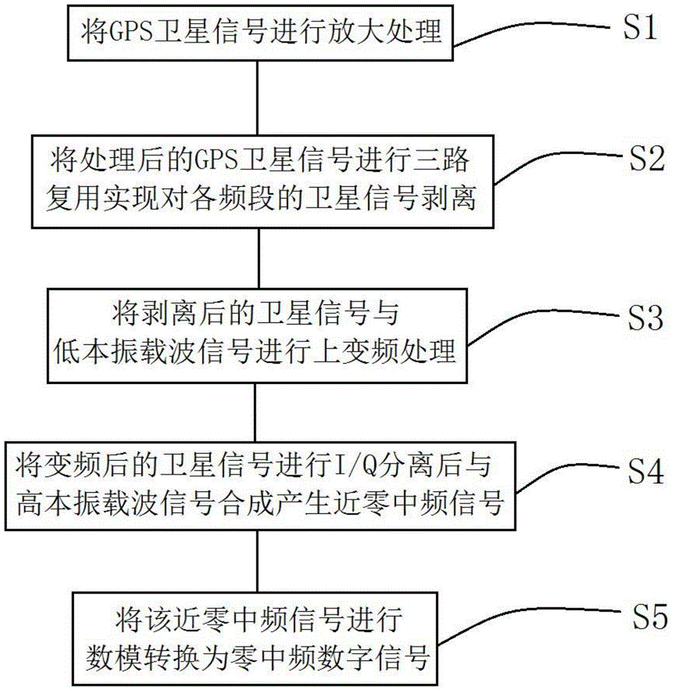
[0026] Such as figure 1 Shown, a kind of method that GPS satellite signal is converted into baseband signal, the method that described GPS satellite signal is converted into baseband signal comprises the following steps:

[0027] Step S1: amplify the GPS satellite signal;

[0028] The specific implementation manner of amplifying the GPS satellite signal in the step S1 may be: receiving the GPS satellite signal from the antenna, and then using a low noise ampl...


PUM


Abstract

The present invention discloses a method for converting a GPS satellite signal to a baseband signal. The method comprises the steps of carrying out amplifying processing on the GPS satellite signal; carrying out three-way multiplexing on the processed GPS satellite signal, thus to realize stripping of satellite signals with various frequency bands; carrying out up-conversion processing on the stripped satellite signal and a low local oscillator carrier signal; carrying out I/Q separation on the converted satellite signal and then combining the converted satellite signal with a high local oscillator carrier signal to produce a near-zero intermediate-frequency signal; and converting the near-zero intermediate-frequency signal to a zero intermediate frequency digital signal through digital-to-analogue conversion. With adoption of the method provided by the present invention, image interference is lowered, crosstalk among various satellite signals is reduced, and an adequate signal to noise ratio is provided for a baseband processing circuit.

Description

technical field [0001] The invention relates to the field of GPS satellite signal processing, in particular to a method for converting GPS satellite signals into baseband signals. Background technique [0002] The Global Positioning System (English: Global Positioning System, referred to as GPS), also known as the Global Positioning System, is a medium-distance circular orbit satellite navigation system. It can provide accurate positioning, speed measurement and high-precision time standards for most areas on the earth's surface. It can meet the needs of users located anywhere in the world or in near-earth space to continuously and accurately determine the three-dimensional position, three-dimensional motion and time. [0003] The GPS satellite signal is synthesized by code division multiple access (CDMA) modulation technology, and its complete signal includes carrier, pseudo-random code and data code. The signal carrier is in the L-band, and the frequencies of the three c...

Claims


Application Information

Patent Timeline
Patent Type & Authority Applications(China)
IPC IPC(8): G01S19/37
Inventor 王超张沛尧刘强邱琅
Owner SHANGHAI HUACE NAVIGATION TECH
Why Eureka
Try Eureka