

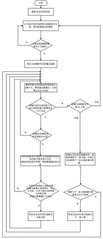
Method for positioning main lines and branch lines through GPS longitude and latitude
A longitude, latitude and branch line technology, applied in the direction of railway signals and safety, to achieve the effect of wide application prospects, fast, accurate and effective positioning, and timely and accurate navigation prompts
- Summary
- Abstract
- Description
- Claims
- Application Information
AI Technical Summary
Problems solved by technology
Method used
Image

Examples
Embodiment Construction
[0032] First, the national railway network is organized according to the public works lines, and the high-density correspondence matrix between the mileage marks and GPS points of each line is obtained according to the following steps:
[0033] Step A, obtain a train LKJ monitoring record file or bullet train EOAS monitoring record file, do interpolation encryption processing as required, 5 to 8 kilometers mark recording points per second, preferably, 6 km mark recording points per second, and remove Duplicate data;
[0034] Step B, obtain the GPS sampling point file of the same train, do interpolation encryption processing as required, 5 to 8 GPS longitude and latitude record points per second, preferably, 6 GPS longitude and latitude record points per second, and remove duplicate data;
[0035] Step C, matching the monitoring record file and the GPS sampling point file of the same train according to the time to obtain the high-density line GPS latitude and longitude and the ...
PUM
 Abstract
Description
Claims
Application Information