DGNSS satellite orbit deviation correction method

A technology of deviation correction and satellite orbit, which is applied in the field of satellite navigation, can solve the problems of inability to separate satellite orbit error and error, achieve effective monitoring and control, wide application range, correction accuracy and stability improvement

Inactive Publication Date: 2016-03-16
GUANGZHOU HI TARGET NAVIGATION TECH
View PDF3 Cites 9 Cited by
  • Summary
  • Abstract
  • Description
  • Claims
  • Application Information

AI Technical Summary

Problems solved by technology

[0005] The purpose of the present invention is to provide a DGNSS satellite orbit deviation correction method, aiming to solve the problem that the existing distance-related geometric interpolation method is affected by factors such as the distribution of the reference station network and the position of the mobile user end and cannot compare the satellite orbit error with other distances. The Problem of Separation of Correlation Errors

Method used


Image

  • DGNSS satellite orbit deviation correction method
  • DGNSS satellite orbit deviation correction method
  • DGNSS satellite orbit deviation correction method

Examples


Embodiment Construction

[0036] In order to make the purpose, technical solution and advantages of the present invention clearer, the present invention will be further described in detail below in conjunction with the accompanying drawings and specific embodiments.

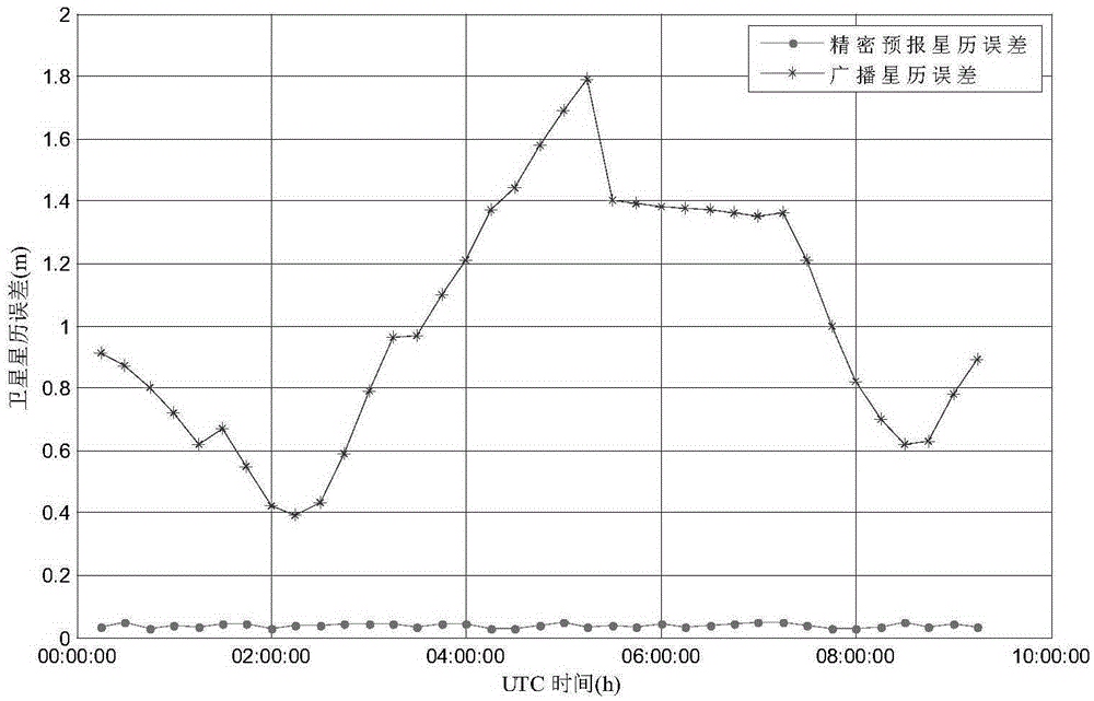
[0037] In order to better understand the present invention, broadcast ephemeris and precise ephemeris and their accuracy analysis are firstly introduced before introducing the embodiments.

[0038] The precise ephemeris is issued by the international GPS service organization IGS. For post-processing and real-time users, the final ephemeris (IGF) and the ultrafast forecast ephemeris (IGU) are the two most important types of ephemeris information. Among them, the accuracy of IGF is better than 5cm, which is the satellite orbit information with the highest accuracy at present, but its time delay is 11 days, which cannot meet the requirements of real-time or quasi-real-time applications. From March 5, 2000, the IGS agency began to provide IGU...


PUM


Abstract

The invention belongs to the satellite navigation field and provides a DGNSS satellite orbit deviation correction method. The method includes the following steps that: broadcast ephemeris and precise prediction ephemeris are utilized to calculate double-difference station-satellite geometric distances; a double-difference orbit correction number of a mobile station and a reference station is calculated according to the double-difference station-satellite geometric distances; an orbit error is corrected according to the double-difference orbit correction number. With the DGNSS satellite orbit deviation correction method adopted, the separation of the orbit error from other distance related errors such as tropospheric and ionospheric delay errors can be realized, and the quality of the orbit deviation correction number can be monitored and controlled more effectively; and correction accuracy and stability are significantly improved. The method has a wider application range. The DGNSS satellite orbit deviation correction method can satisfy the requirements of the correction of orbits of baselines of different lengths such as medium-short baselines, medium-long baselines and ultra-long baselines.

Description

technical field [0001] The invention relates to the field of satellite navigation, in particular to a DGNSS satellite orbit deviation correction method. Background technique [0002] The global satellite navigation system GNSS (Global Navigation Satellite System), of which DGNSS (Differential Global Navigation Satellite System) is a differential global satellite navigation system, the global satellite navigation system includes the GPS global satellite navigation system of the United States, the GLONASS global satellite navigation system of Russia, the Beidou global satellite navigation system of China ( under construction) and Europe's Galileo global satellite navigation system (under construction). Its positioning principle is to use four or more satellites to perform resection on the ground position, and solve the three-dimensional coordinates and clock difference information of the ground receiver. Therefore, the position information of satellites is considered known, a...

Claims


Application Information

Patent Timeline
Patent Type & Authority Applications(China)
IPC IPC(8): G01S19/41
CPCG01S19/41
Inventor 李成钢
Owner GUANGZHOU HI TARGET NAVIGATION TECH
Why Eureka
Try Eureka