
Visual perception enlightening high-resolution remote-sensing image segmentation method

A high-resolution, visual perception technology applied in the field of image processing

Inactive Publication Date: 2016-04-20
NAVAL AERONAUTICAL & ASTRONAUTICAL UNIV PLA
View PDF3 Cites 10 Cited by
  • Summary
  • Abstract
  • Description
  • Claims
  • Application Information

AI Technical Summary

Problems solved by technology

The method is based on the fact that the human visual system can treat the textured area and the spectrally uniform area as a whole, extracting the boundary of the spectrally uniform area and the boundary of the spectrally changing textured area in the image respectively, and then effectively fusing the two to achieve image segmentation , solve the problems of using single spectral information and inaccurate boundary positioning in the existing remote sensing image segmentation methods, improve the segmentation accuracy of remote sensing segmentation, and reduce the post-processing complexity in the process of remote sensing information extraction

Method used


Image

  • Visual perception enlightening high-resolution remote-sensing image segmentation method
  • Visual perception enlightening high-resolution remote-sensing image segmentation method
  • Visual perception enlightening high-resolution remote-sensing image segmentation method

Examples


Embodiment Construction

[0043] The present invention will be described in further detail below in conjunction with the accompanying drawings and examples.

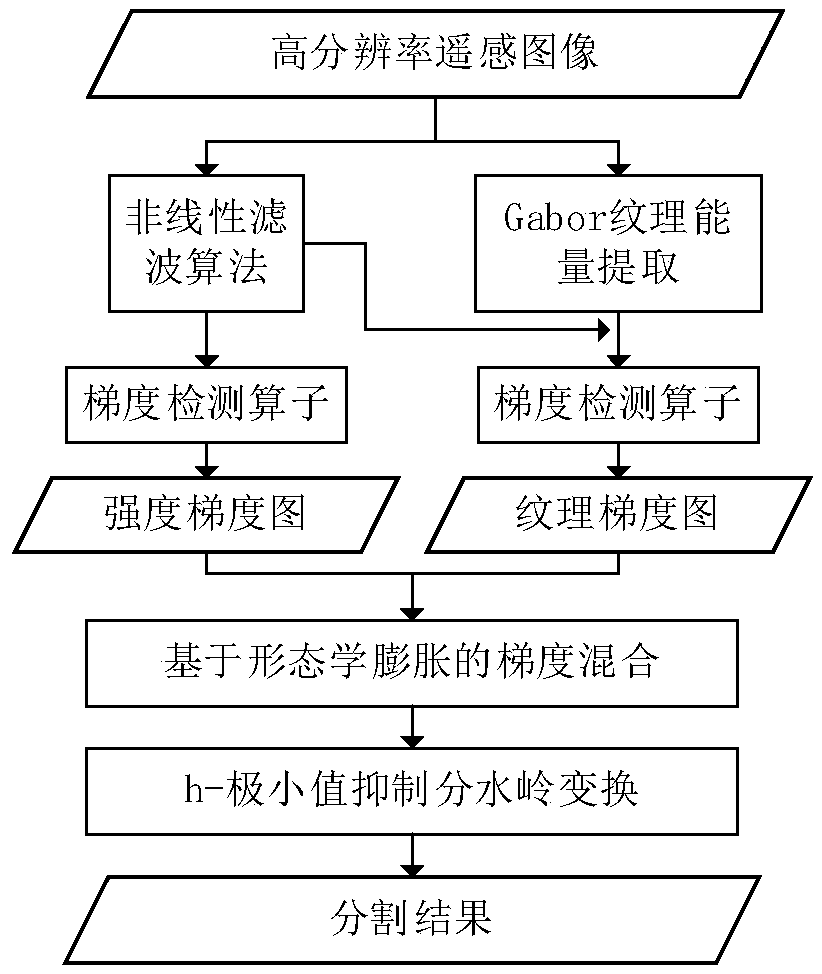
[0044] figure 1It is an overall flow chart of the present invention, and the implementation process of this embodiment will be described in detail below in conjunction with the flow chart.

[0045] Step S1, extracting the intensity gradient of the input image, the process is as follows:

[0046] (S1-1) Calculate the smooth scale parameter σ of the input high-resolution remote sensing image to obtain the smooth scale distribution of the image. In this embodiment, the window width for calculating the local scale is set to a value of 11 to 15 to achieve better results. Here the window width is set to 13.

[0047] (S1-2) Use the bilateral filtering method based on the Tukey'sbiweight function to smooth the image, and the scale parameter in the Tukey'sbiweight function is the result calculated in step (S1-1).

[0048] For true color remote sensing ...


PUM


Abstract

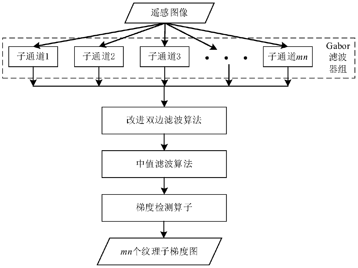
The invention discloses a visual perception enlightening high-resolution remote-sensing image segmentation method, and the method enables an object boundary in an image to be divided into an intensity boundary corresponding to a spectrum homogeneous area, and a texture boundary corresponding to a spectrum change area, and respectively extracts two types of visual information which serve as the main basis of segmentation. The method comprises the steps: filtering noise and texture information in the image through a nonlinear filtering method, and obtaining the intensity gradient through a gradient operator; analyzing the texture features of the image through employing a Gabor filter, enabling the filtering output of a plurality of channels to be merged and processed through the gradient operator, and obtaining the texture gradient of the image; carrying out the fusion of the intensity gradient and the texture gradient, carrying out the conversion of the gradient image after fusion through watershed conversion, and achieving the segmentation of the image. Compared with the prior art, the method improves the boundary accuracy of image segmentation, reduces the over-segmentation and under-segmentation phenomena, and can be effectively used in the field of high-resolution remote-sensing image information processing.

Description

technical field [0001] The invention belongs to the technical field of image processing, and further relates to a segmentation method for simulating a visual perception mechanism in the technical field of high-resolution remote sensing image segmentation. The invention is mainly used for the segmentation of high-resolution satellite remote sensing images and aerial remote sensing images, so as to achieve the purpose of extracting ground object information in the images. Background technique [0002] High-resolution remote sensing images can provide rich details of ground objects, but also increase the internal spectral differences in homogeneous regions and present diverse texture characteristics. In addition, the sensor will introduce noise during the imaging process, which increases the accuracy of remote sensing images. Difficulty of segmentation. In recent years, high-resolution remote sensing images are mainly based on the Geographic Object-Oriented Image Analysis (GEO...

Claims


Application Information

Patent Timeline
Patent Type & Authority Applications(China)
IPC IPC(8): G06T7/00
CPCG06T2207/10032
Inventor 张立民张建廷钟兆根徐涛张兵强
Owner NAVAL AERONAUTICAL & ASTRONAUTICAL UNIV PLA
Learn More