
Large-area farmland crop water status monitoring method and system based on unmanned aerial vehicle infrared thermal image acquisition

An image acquisition and field crop technology, applied in the field of agricultural irrigation, can solve the problems of large spatial variability, can only provide information on individual plants or individual leaves, application difficulties, etc., to achieve a large monitoring range, improve the level of agricultural modernization, monitoring Flexible range of effects

Inactive Publication Date: 2016-04-27
HOHAI UNIV
View PDF5 Cites 31 Cited by
  • Summary
  • Abstract
  • Description
  • Claims
  • Application Information

AI Technical Summary

Problems solved by technology

Indexes based on the response of crops to water drops are generally considered to better reflect the water deficit of crops, and there are many applications, such as leaf moisture content, leaf water potential, stem diameter change, stomatal conductance, cell change, leaf temperature difference etc. These generally require the use of specific instruments, and usually can only provide information on individual plants or individual leaves. Considering the large spatial variability of these indicators in the field, there are certain difficulties in application

Method used


Image

  • Large-area farmland crop water status monitoring method and system based on unmanned aerial vehicle infrared thermal image acquisition
  • Large-area farmland crop water status monitoring method and system based on unmanned aerial vehicle infrared thermal image acquisition
  • Large-area farmland crop water status monitoring method and system based on unmanned aerial vehicle infrared thermal image acquisition

Examples


Embodiment Construction

[0027] Below in conjunction with specific embodiment, further illustrate the present invention, should be understood that these embodiments are only used to illustrate the present invention and are not intended to limit the scope of the present invention, after having read the present invention, those skilled in the art will understand various equivalent forms of the present invention All modifications fall within the scope defined by the appended claims of the present application.

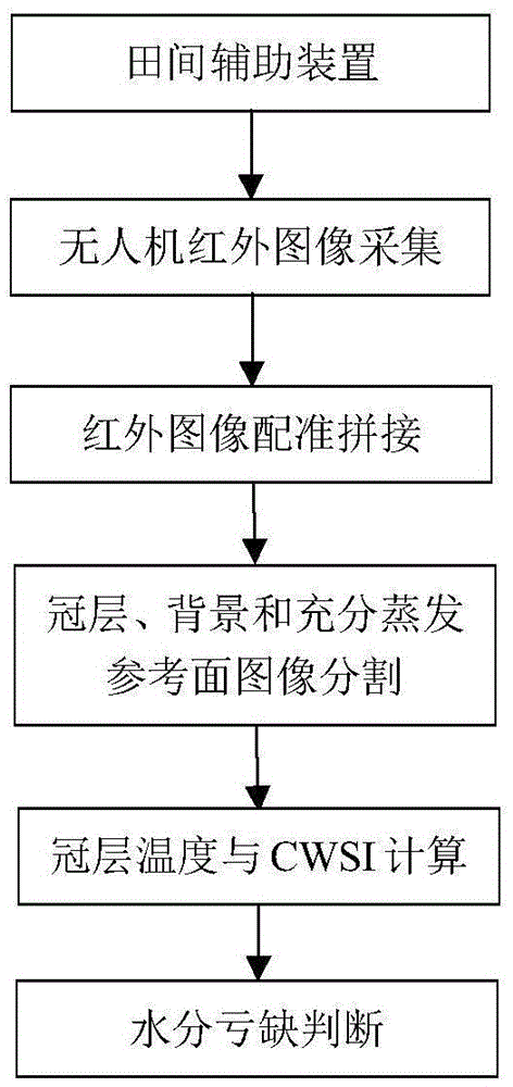
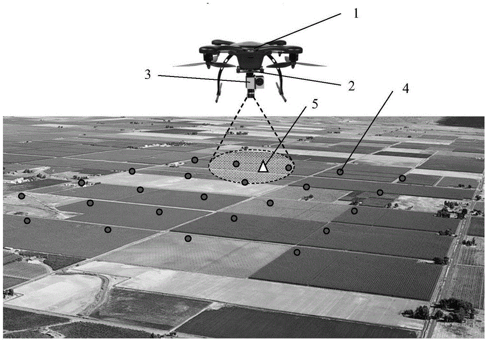
[0028] figure 1 is a schematic flow chart of the present invention, figure 2 is a schematic diagram of the infrared image shooting of the present invention, according to figure 1 and figure 2 , the method for monitoring the moisture status of large-area farmland crops based on UAV infrared thermal image acquisition is described as follows:

[0029] (1) Set up auxiliary devices in the field, that is, the field air temperature sensor 4 and the ground full evaporation reference surface 5, wherei...


PUM


Abstract

The invention provides a large-area farmland crop water status monitoring method based on unmanned aerial vehicle infrared thermal image acquisition. The method comprises the following steps: 1)arranging auxiliary devices in the field, that is, field air temperature sensors and a ground full-evaporation reference surface; 2) carrying out large-area infrared image acquisition on farmland corps through an infrared thermal imaging system fixed to an unmanned aerial vehicle through a pan-tilt, and synchronously triggering a GPS module to obtain positioning information of the corresponding images; and 3) receiving by a ground data processing system the infrared images and the positioning information, carrying out image registering, splicing and segmentation on the images, extracting spatial distribution of canopy temperature and ground full-evaporation reference surface temperature, calculating the temperature of leaves when the stomas of the crops are fully closed, and finally, calculating water deficit index of the crops and carrying out highlighted display and early warning on the areas, where the water deficit index of the crops is higher than a critical value. Besides, the invention also provides a system suitable for the method. The method and system are suitable for large-area farmland crop water status monitoring, facilitate to realize agriculture precision irrigation and improve agricultural modernization level.

Description

technical field [0001] The invention relates to the technical field of agricultural irrigation, in particular to a method and system for monitoring the water state of large-area farmland crops based on infrared thermal image acquisition. Background technique [0002] There are many methods for monitoring the moisture status of farmland crops, mainly including monitoring based on soil moisture (or water potential) and crop physiological growth indicators, and very few monitoring through meteorological indicators. Indexes based on the response of crops to water drops are generally considered to better reflect the water deficit of crops, and there are many applications, such as leaf moisture content, leaf water potential, stem diameter change, stomatal conductance, cell change, leaf temperature difference etc. These generally require the use of specific instruments, and usually can only provide information on individual plants or individual leaves. Considering the large spatial...

Claims


Application Information

Patent Timeline
IPC IPC(8): G01V8/10G01N21/84G01J5/10
CPCG01V8/10G01J5/10G01N21/84
Inventor 徐俊增吕玉平杨士红缴锡云王卫光
Owner HOHAI UNIV
Learn More