Mountain vegetation vertical zone investigation monitoring method based on UAV

A technology of unmanned aerial vehicle and vegetation zone, applied in control/regulation system, non-electric variable control, instrument and other directions, can solve the problems of low elevation positioning accuracy of vegetation zone boundary, difficult identification of vegetation zone, mixed pixel phenomenon, etc. To achieve the effect of reducing personal risk, good accessibility, and good representation

Active Publication Date: 2016-04-27
INST OF GEODESY & GEOPHYSICS CHINESE ACADEMY OF SCI
View PDF7 Cites 12 Cited by
  • Summary
  • Abstract
  • Description
  • Claims
  • Application Information

AI Technical Summary

Problems solved by technology

[0006] Aiming at the defects of the prior art, the object of the present invention is to provide a method for surveying and monitoring the vertical zone of mountainous vegetation based on unmanned aerial vehicles, aiming at solving the problem of prominent mixed pixels and the phenomenon of vegetation zone in satellite remote sensing of the vertical zone of mountainous vegetation in the prior art. The difficulty of identification and the low accuracy of elevation positioning of vegetation zone boundaries

Method used


Image

  • Mountain vegetation vertical zone investigation monitoring method based on UAV
  • Mountain vegetation vertical zone investigation monitoring method based on UAV

Examples


Embodiment Construction

[0023] In order to make the object, technical solution and advantages of the present invention clearer, the present invention will be further described in detail below in conjunction with the accompanying drawings and embodiments. It should be understood that the specific embodiments described here are only used to explain the present invention, not to limit the present invention.

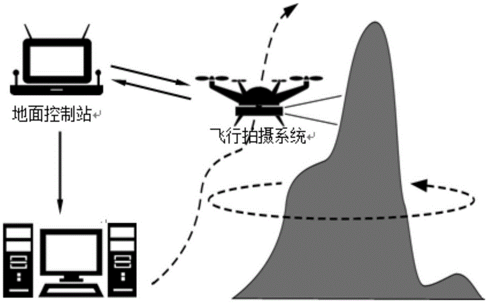
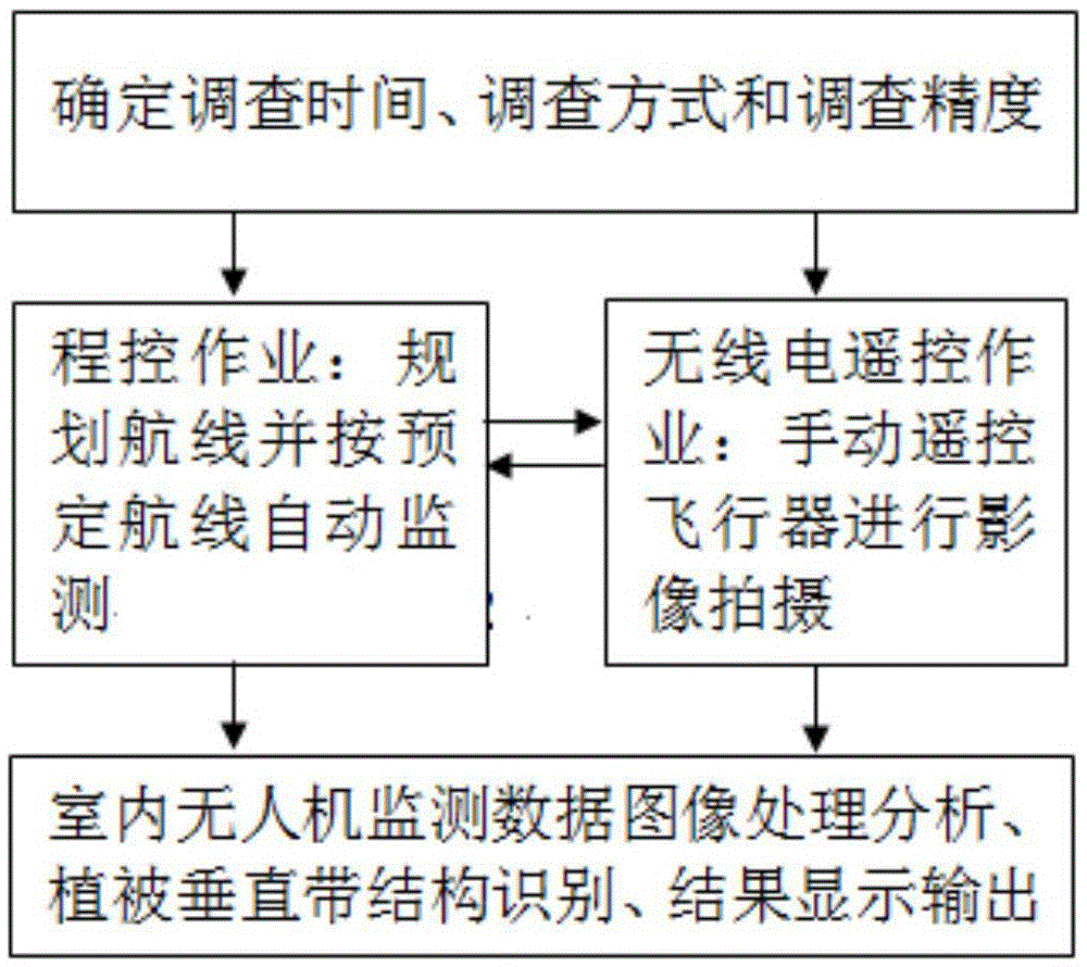
[0024] The invention belongs to the field of monitoring the type and structure of mountainous vegetation, and in particular relates to a system and method for surveying and monitoring the vertical zone of mountainous vegetation based on an unmanned aerial vehicle. The purpose of the present invention is to provide an unmanned aerial vehicle based on the shortcomings of the existing mountain vegetation vertical zone survey and monitoring technology, the manual work workload is large, the survey line is often limited, and the satellite remote sensing vegetation zone boundary elevation positioning accu...


PUM


Abstract

The present invention provides a mountain vegetation vertical zone investigation monitoring method based on a UAV. The method comprises the steps of (S1) determining an investigation time, an investigation mode and investigation precision, (S2) planning a route and carrying out automatic monitoring according to a preset route if the investigation mode is a programmed control operation mode, and manually controlling an aircraft to carrying out image capturing and obtaining monitoring data if the investigation mode is a radio remote control operation mode, (S3) carrying out space correcting processing on each image in the monitoring data, realizing the space connection of images, carrying out visual interpretation or computer automatic classification by using the spectrum and texture structure differences of different vegetation zones in a remote sensing image, identifying a vegetation vertical zone boundary, and completing the statistical measurement analysis of a vegetation vertical zone structure and result output through a geographic information system. According to the mountain vegetation vertical zone investigation monitoring method, time and labor are saved, climbing a mountain to carry out sampling positioning by investigation and monitoring personnel is not needed, an investigation result is processed by using the image analysis technology, the vertical vegetation zone identification precision is high, and the positioning is more accurate.

Description

technical field [0001] The invention belongs to the field of monitoring the type and structure of mountainous vegetation, and more specifically relates to a method for surveying and monitoring the vertical zone of mountainous vegetation based on an unmanned aerial vehicle. Background technique [0002] The vertical belt of mountain vegetation refers to the vertical differentiation of mountain vegetation types showing a certain order and arrangement structure with the increase of altitude. The vertical zone of mountain vegetation is not only the basic feature of mountain environment structure, but also one of the classic paradigms of geoscience research. It is still an important content of mountain environment monitoring and scientific research. [0003] At present, there are mainly two ways to obtain information on the vertical zone of mountain vegetation: manual field survey and satellite remote sensing monitoring. Among them, the traditional method of obtaining informatio...

Claims


Application Information

Patent Timeline
Patent Type & Authority Applications(China)
IPC IPC(8): G05D1/08G05D1/10
CPCG05D1/0808G05D1/101
Inventor 肖飞杜耘冯奇
Owner INST OF GEODESY & GEOPHYSICS CHINESE ACADEMY OF SCI
Why Eureka
Try Eureka