Unmanned aerial vehicle remote sensing image collection system and method based on Android device

An image acquisition system and machine-based remote sensing technology, applied in image communication, TV system parts, color TV parts, etc., can solve the problems of high equipment cost and development cost, small resolution of satellite remote sensing images, and uneven planting of crops And other issues

Inactive Publication Date: 2016-06-08
SOUTH CHINA AGRI UNIV
View PDF5 Cites 10 Cited by
  • Summary
  • Abstract
  • Description
  • Claims
  • Application Information

AI Technical Summary

Problems solved by technology

Different from the large number of continuous planting in the United States and other countries, the farmland planting in my country is scattered and the crops are not uniform, and the average area of ​​the field is small, which makes it difficult to reflect the agricultural information on the remote sensing image; in addition, because the satellite has a certain cycle around the earth, The image acquisition can only be carried out when the satellite reaches the sky above the farmland, the real-time performance is poor and the image is easily disturbed by cloud cover and water vapor
Based on the above analysis, using the previous satellite images and the agricultural conditions identified by the ground personnel, using mathematical models to model, and inputting future satellite images into the established model to obtain the agricultural conditions at the time of image shooting, there are the following Disadvantages: (1) The resolution of satellite remote sensing images is small, and it can only roughly analyze the general agricultural conditions of the fields, but it is powerless to analyze small fields or small scales; (2) The real-time performance of satellite remote sensing images is poor, and it takes time (3) Satellite remote sensing images are easily blocked by clouds and interfered by water vapor
It uses unmanned aerial vehicles equipped with cameras, microcontrollers, sensor groups, GPS modules, data storage devices, network modules and other equipment to form a low-altitude unmanned aerial vehicle remote sensing platform to collect images of target fields. This method has the following disadvantages: ( 1) Since the load of micro-sized drones is usually small (≤5kg) and the battery life is short (≤40min), the equipment on board usually needs to be powered by the power supply of the drone, and compared with the drone itself, it increases A lot of weight, thus reducing the life time of the UAV; (2) Because different devices have different communication interfaces, it is more difficult in development; (3) Portability and replacement are poor, if the device fails, you need to Maintenance by personnel with professional skills; (4) equipment cost and development cost are relatively high

Method used


Image

  • Unmanned aerial vehicle remote sensing image collection system and method based on Android device
  • Unmanned aerial vehicle remote sensing image collection system and method based on Android device
  • Unmanned aerial vehicle remote sensing image collection system and method based on Android device

Examples


Embodiment Construction

[0027] The present invention will be further described in detail below in conjunction with the embodiments and the accompanying drawings, but the embodiments of the present invention are not limited thereto.

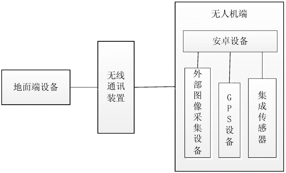
[0028] Such as figure 1 , a UAV remote sensing image acquisition system based on an Android device, including a UAV end, a ground end device, and a wireless communication device placed in the field, wherein the UAV end is equipped with an Android device, an external image acquisition device, and a GPS device , integrated sensors, external image acquisition equipment, GPS equipment, and integrated sensors respectively transmit the captured image preview frame, GPS coordinates of the aircraft, and environmental information to the Android device during operation, and the Android device transmits the collected information to the Android device through a wireless communication device. The ground terminal equipment, the control command of the ground terminal equipment is trans...


PUM


Abstract

The invention discloses an unmanned aerial vehicle remote sensing image collection system based on an Android device, which is characterized by comprising an unmanned aerial vehicle terminal, a ground terminal device and a wireless communication device placed in a field, wherein the Android device, an external image collection device, a GPS device and an integrated sensor are mounted on the unmanned aerial vehicle terminal, when at work, the external image collection device, the GPS device and the integrated sensor respectively transmit collected information to the ground terminal device through the wireless communication device, and a control instruction of the ground terminal device is transmitted by the wireless communication device to the Android device. According to the image collection system and method disclosed by the invention, the requirements on the professional skills of an operator are relatively low, the Android device is low in cost and is easy to replace, so that the development and use costs of the entire system are reduced.

Description

technical field [0001] The present invention relates to the field of image acquisition, in particular to a remote sensing image acquisition system and method for drones based on Android devices. Background technique [0002] Farming situation analysis of farmland crops is one of the important tasks of plant protection. It can quickly and accurately predict the status of crops infected by diseases and insect pests, water and fertilizer stress, crop lodging, growth and yield. Especially for explosive pests and diseases, computer technology can accurately identify changes that are difficult for human eyes to distinguish, such as subtle changes in the color and texture of specific parts of crops. The traditional agricultural situation analysis is to select and delineate multiple sampling blocks in the field, and use manual entry into the field to screen diseases and so on, so as to determine the corresponding damage level and degree. This method has the problems of low accuracy...

Claims


Application Information

Patent Timeline
Patent Type & Authority Applications(China)
IPC IPC(8): H04N5/232
CPCH04N23/66H04N23/617
Inventor 邓继忠何明昊兰玉彬任高生
Owner SOUTH CHINA AGRI UNIV
Why Eureka
Try Eureka