A Lunar Satellite Orbit Determination Method Based on Information Fusion

A measurement method and technology for satellite orbits, which are used in positioning, measurement devices, mapping and navigation, etc., can solve the problems of inability to obtain effective information and the impact of orbit measurement accuracy, and achieve the effect of improving orbit measurement accuracy.

Inactive Publication Date: 2014-02-12
BEIJING AEROSPACE CONTROL CENT
View PDF0 Cites 8 Cited by
  • Summary
  • Abstract
  • Description
  • Claims
  • Application Information

AI Technical Summary

Problems solved by technology

Although this method can meet the current mission requirements, there are potential problems as follows: (1) All measurement information comes from earth stations, and the accuracy of orbit determination will be affected by the long distance between the earth and the moon; (2) The measurement time is strictly limited by the ground Constraints on the station measurement and control arc (that is, the continuous observation time period), when the satellite is outside the measurement and control arc or on the back of the moon, no effective information can

Method used


Image

  • A Lunar Satellite Orbit Determination Method Based on Information Fusion
  • A Lunar Satellite Orbit Determination Method Based on Information Fusion
  • A Lunar Satellite Orbit Determination Method Based on Information Fusion

Examples


Embodiment Construction

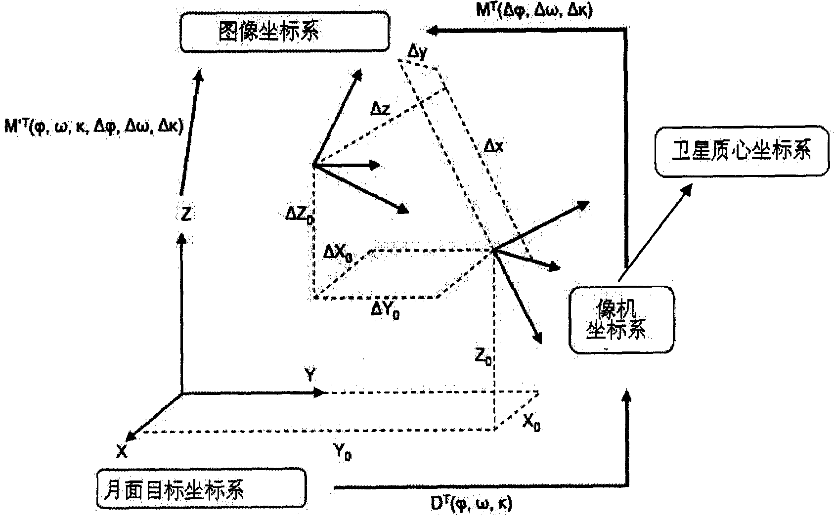
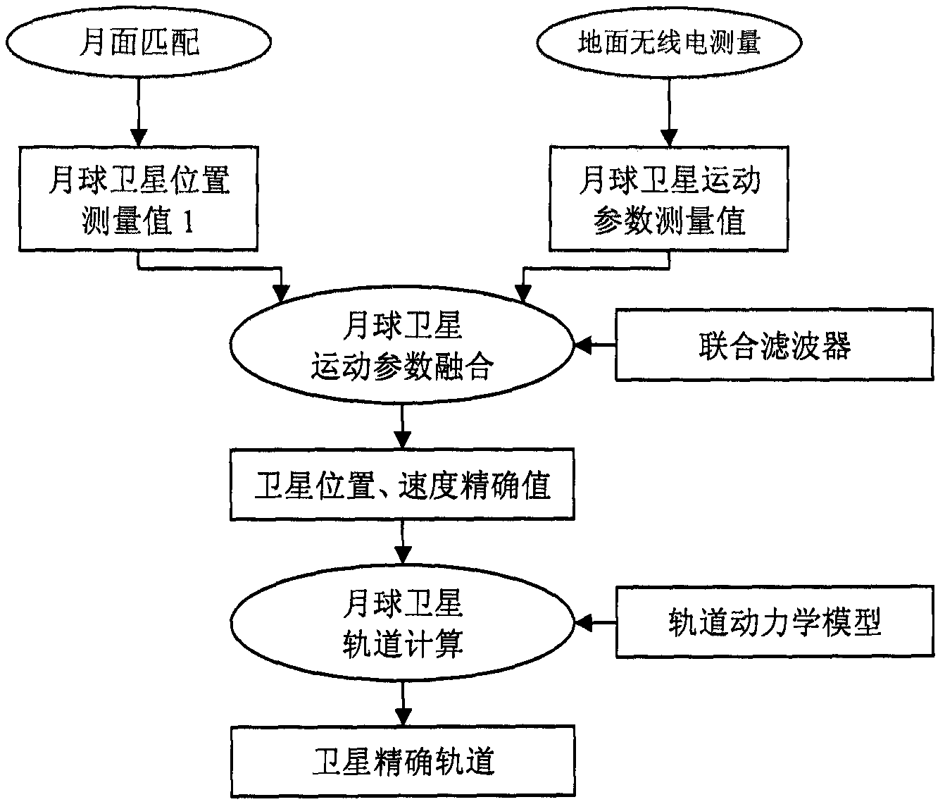
[0029] Through the matching of the high-resolution three-line CCD camera image carried by the lunar exploration satellite and the high-precision image map near the sub-satellite point, the precise observation position of the satellite in the fixed lunar coordinate system at that time is determined, and the satellite motion observation information is obtained through ground radio methods. Based on the orbit dynamics model, the fusion of matching positioning information and radio measurement information is realized, and the precise orbit of the lunar satellite is finally obtained.

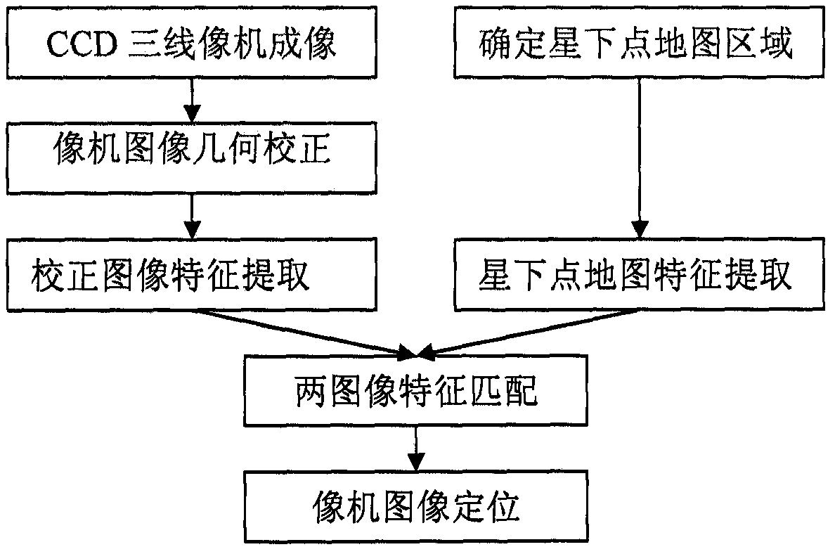
[0030] figure 1 Shown is the process of determining the camera imaging position by matching the satellite payload camera image with the lunar surface map. The satellite payload camera is a three-line CCD stereo camera. Firstly, the original image of the camera is geometrically corrected into an ortho image by combining the projection relationship of the three-line camera. Construct a feature extract...


PUM

PropertyMeasurementUnit
Image resolutionaaaaaaaaaa

Abstract

The invention relates to the technical field of information acquisition and processing, and relates to a method for determining the orbit of a lunar satellite. The method is to fuse the motion information of the lunar satellite obtained by the earth survey station through radio measurement methods with the satellite position information obtained by precise image matching during the lunar satellite orbiting the moon, and calculate the lunar satellite based on the optimized fusion information. precise track. The specific steps are as follows: 1) Firstly, based on the matching results of the spaceborne high-resolution camera image and the high-precision lunar surface map, the precise position of the satellite in the lunar fixed coordinate system is solved; 3) Construct a joint filter to realize the fusion of satellite matching position and ground radio measurement information; 4) Based on the information fusion results, the precise orbit of the lunar satellite is calculated through the orbit dynamics model.

Description

technical field [0001] The invention relates to the technical field of information acquisition and processing, in particular to a method for satellite orbit determination based on fusion of lunar surface visual image information and ground radio measurement information. Background technique [0002] At present, the orbit measurement parameters of my country's lunar exploration satellites are all obtained by radio measurement methods from stations on the earth. The methods include unified S-band carrier measurement and very long baseline interferometry. Although this method can meet the current mission requirements, there are potential problems as follows: (1) All measurement information comes from earth stations, and the accuracy of orbit determination will be affected by the long distance between the earth and the moon; (2) The measurement time is strictly limited by the ground Due to the constraints of the station measurement and control arc (that is, the continuous observ...

Claims


Application Information

Patent Timeline
IPC IPC(8): G01S5/02G01C11/00
Inventor 卜彦龙唐歌实贺军曹建峰王保丰
Owner BEIJING AEROSPACE CONTROL CENT
Why Eureka
Try Eureka