Data fusion calibration method of catadioptric panorama camera and laser radar

A catadioptric panorama and lidar technology, which is applied in the field of data fusion of environmental perception systems, can solve problems such as the inability of cameras to fully display image information, the difficulty of joint calibration of images, and the inability of sensors to obtain accurate and complete environmental information.

Inactive Publication Date: 2016-06-15
XIAN UNIV OF SCI & TECH
View PDF2 Cites 38 Cited by
  • Summary
  • Abstract
  • Description
  • Claims
  • Application Information

AI Technical Summary

Problems solved by technology

[0007] The problems existing in the existing technology are: 1) a single sensor cannot accurately and completely obtain environmental information; 2) traditional cameras cannot completely display image information within a 360-degree range; The panoramic imaging image is not easy to carry out joint calibration

Method used


Image

  • Data fusion calibration method of catadioptric panorama camera and laser radar
  • Data fusion calibration method of catadioptric panorama camera and laser radar
  • Data fusion calibration method of catadioptric panorama camera and laser radar

Examples


Embodiment Construction

[0087] In order to further illustrate the technical solutions adopted by the present invention, the specific implementation manners of the present invention will be described in detail below in conjunction with the accompanying drawings. This embodiment is only suitable for illustrating and explaining the present invention, and does not constitute a limitation to the protection scope of the present invention.

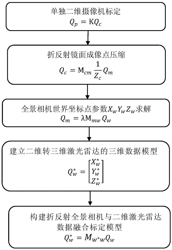
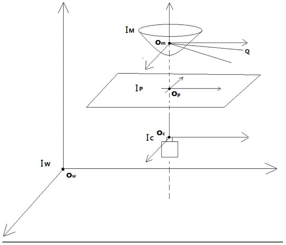
[0088] The present invention is a catadioptric panoramic camera and laser radar data fusion calibration method, such as figure 1 As shown, its joint calibration method includes steps:

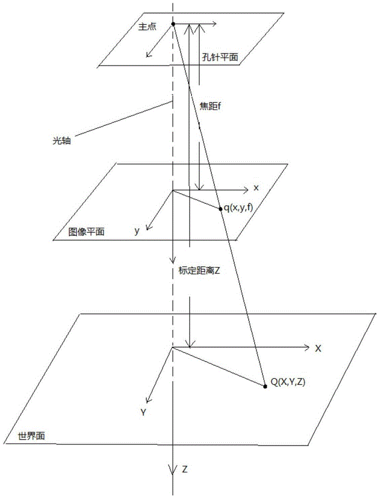
[0089] 1. Calibration of a single two-dimensional camera, from the imaging coordinate point and the world coordinate point, the internal parameter calibration of the camera is carried out to obtain the internal parameter matrix K of the camera;

[0090] 2. The imaging point of the catadioptric mirror is compressed, and the parameter X of the refraction point of the catadioptric mirror i...


PUM


Abstract

The invention discloses a data fusion calibration method of a catadioptric panorama camera and a laser radar. A data fusion calibration structure comprises the laser radar and the single-viewpoint catadioptric panorama camera mounted on an environment sensing system body. The calibration method comprises the steps that 1) a parameter K in the camera is calibrated; 2) parameters XmYmZm of refraction points of the catadioptric surface are solved; 3) parameters XwYwZw of world coordinate points of the panorama camera are solved; 4) parameters Xw*Yw*Zw* of f world coordinate points of the laser radar are measured; and 5) the panorama camera and the laser radar are calibrated in a fused manner. According to the invention, reasonable and fused data of the laser radar and the panorama camera are designed, internal parameters of the panorama camera can be calibrated effectively, and reasonable, rapid and effective schemes are provided for range finding and positioning in the environment sensing system.

Description

technical field [0001] The invention belongs to the technical field of data fusion of an environment perception system, and in particular relates to a data fusion calibration method of a catadioptric panoramic camera and a laser radar. Background technique [0002] The environmental perception system has always been a hot spot in the core technology research of mobile robots, and it is the key to realize the automation and intelligence of mobile robots. In order to realize the self-environment perception and autonomous walking function of the mobile robot, the construction of the ranging and positioning platform plays an important role. [0003] Lidar and cameras are the two most commonly used distance sensing elements at this stage. Among them, the camera can quickly acquire images in space through digital image processing and calibration algorithms to achieve positioning; the laser radar can directly obtain orientation and distance information. However, mobile robots wal...

Claims


Application Information

Patent Timeline
Patent Type & Authority Applications(China)
IPC IPC(8): G06T7/00G06T5/50
CPCG06T5/50G06T2207/10004G06T2207/10044
Inventor 马宏伟王岩尚万峰薛旭升王川伟马琨
Owner XIAN UNIV OF SCI & TECH
Why Eureka
Try Eureka