Earthwork quantity measuring method based on UAV photographic technology

A technology for engineering earthwork and quantity measurement. It is applied in the direction of measurement devices and instruments, and can solve the problems of few applications, large workload of field operators, and incompatibility.

Active Publication Date: 2016-07-20
KUNSHAN DIGITAL CITY INFORMATION TECH
View PDF6 Cites 35 Cited by
  • Summary
  • Abstract
  • Description
  • Claims
  • Application Information

AI Technical Summary

Problems solved by technology

However, the RTK signal is affected by the water surface, high-voltage lines, trees, buildings, etc. At this time, this method is not suitable
[0008] As a new technology, three-dimensional laser scanning measurement method has the advantages of fast acquisition speed, high density, high precision, non-contact and wide measurement range. The price of the instrument is very expensive, so that it is less used in general earthworks
[0010] However, in the above calculation methods, there are still the following defects: t

Method used


Image

  • Earthwork quantity measuring method based on UAV photographic technology
  • Earthwork quantity measuring method based on UAV photographic technology
  • Earthwork quantity measuring method based on UAV photographic technology

Examples


Embodiment approach

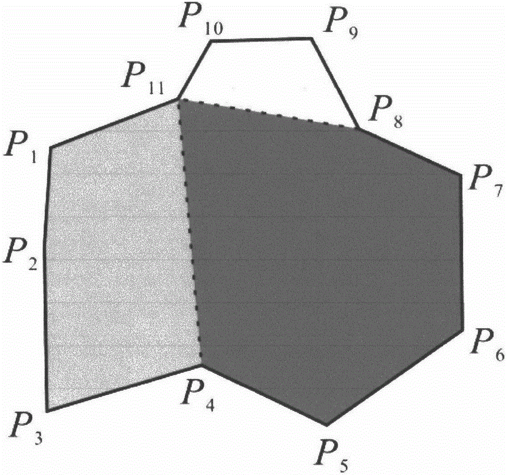
[0111] Such as image 3 As shown, the boundary recognition algorithm proposed by the present invention is based on convex polygons, so it is necessary to perform convex polygon processing on the boundary range lines of the survey area. As an implementation, P1, P2, ..., P11 are the vertices of the boundary line of the survey area, and the boundary is neither a convex polygon nor a concave polygon. The dotted lines P4P11 and P8P11 divide the survey area into three convex polygons P1P2P3P4P11, P4P5P6P7P8P11 and P8P9P10P11.

[0112]Simultaneously, in order to reflect the topological relationship between each vertex, that is, the adjacency relationship between points and the adjacency relationship between convex polygons and convex polygons, in the present invention, the encoding format adopted is "point number, X coordinate, Y coordinate, the number of the next adjacent point, and the number of the convex polygon". Specifically, the topological coding of the boundary line is sh...


PUM


Abstract

The invention provides an earthwork quantity measuring method based on a UAV photographic technology. The earthwork quantity measuring method comprises the steps of: S1, acquiring point cloud data; S2, preprocessing the acquired point cloud data; S3, and carrying out earthwork calculation by adopting an integral method. The earthwork quantity measuring method based on the UAV photographic technology has the advantages of being high in measurement precision and good in working efficiency, and being capable of saving a lot of labor cost. Specifically, the earthwork quantity measuring method acquires dense point cloud altitude data of surface on site and adopts the integral method for calculating earthwork, generates dense point cloud data covering a measured region by using a few image control points through photographic measurement and calculation, and can obtain accurate measurement result by utilizing integral according to a set earthwork measured boundary and a designed elevation.

Description

technical field [0001] The invention relates to an earthwork measurement method, in particular to an engineering earthwork measurement method based on unmanned aerial vehicle photography technology. Background technique [0002] In order to reasonably arrange the project schedule, accurately calculate the project cost, and improve the project quality, it is usually necessary to calculate the earthwork volume efficiently and accurately. Engineering earthwork measurement is an important part of the application of surveying and mapping engineering. The accuracy of earthwork measurement in civil engineering construction directly affects the cost and progress of the project, and is even the main factor that generates engineering disputes. Therefore, the quality of earthwork measurement is crucial in engineering construction. plays a vital role in. [0003] In the process of earthwork measurement, it is necessary to collect the earthwork measurement data first, and then calculate...

Claims


Application Information

Patent Timeline
IPC IPC(8): G01B21/00
CPCG01B21/00
Inventor 朱彩英陈良浩朱杰施尊淳刘晨亮王道亮巩金忠
Owner KUNSHAN DIGITAL CITY INFORMATION TECH
Why Eureka
Try Eureka