Interaction-type intelligent GPS

An interactive, GPS terminal technology, applied in the field of GPS navigation, can solve the problems of dangerous driving, inaccurate estimated time of arrival, inaccurate estimated time of arrival of GPS navigation, etc., to achieve the effect of ensuring personal safety

Inactive Publication Date: 2016-07-20
BEIJING QIHOO TECH CO LTD +1
View PDF6 Cites 8 Cited by
  • Summary
  • Abstract
  • Description
  • Claims
  • Application Information

AI Technical Summary

Problems solved by technology

[0005] 1. The estimated arrival time of GPS navigation is inaccurate, and the actual arrival time at the destination is often closely related to the road conditions. The traditional optimization method is to combine the real-time road conditions of the electronic map to select the optimal route. However, the electronic map can only obtain the current road conditions, and the The road conditions will change during driving, so the pre-calculated estimated time of arrival is not accurate enough
[0006] 2. Unable to see the location of fellow teammates, choosing different routes on the road leads to a deviation in arrival time
[0007] 3. The GPS information is displayed on the center console, and the driver needs to look away, causing driving hazards
[0008] 4. The GPS control button is on the center console, and the driver needs to divert his eyes, causing driving danger
[0009] 5. The GPS signal is unstable. When encountering a weak signal or entering a tunnel, the real-time speed cannot be obtained, resulting in inaccurate estimation of the estimated arrival time

Method used


Image

  • Interaction-type intelligent GPS
  • Interaction-type intelligent GPS
  • Interaction-type intelligent GPS

Examples


Embodiment Construction

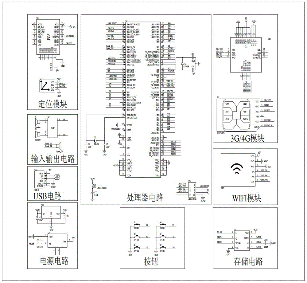
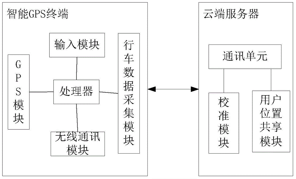
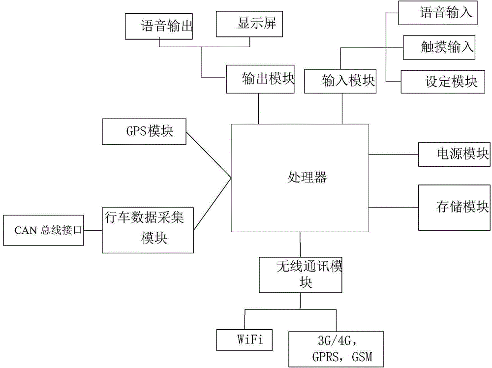
[0040] Along with the rise of GPS technology, along with the development of science and technology, present automobile all has navigation function, but GPS navigator still has many deficiencies, the present invention is an interactive intelligent GPS, combined with cloud computing, calibrates estimated time of arrival. At the same time, the location of other users is displayed, and the GPS control interface has been optimized to bring users a better user experience. At the same time, it improves the accuracy of navigation time and driving safety.

[0041] The present invention will be further described below in conjunction with the accompanying drawings and specific embodiments.

[0042] as attached figure 1 As shown, it includes: an intelligent GPS terminal and a cloud server, and the GPS terminal and the cloud server are connected to each other; wherein the intelligent GPS terminal includes:

[0043] The input module is used to collect input instructions;

[0044] Wireless...


PUM


Abstract

The invention discloses an interaction-type intelligent GPS comprising an intelligent GPS terminal and a cloud server. The interaction-type intelligent GPS is characterized in that the intelligent GPS terminal and the cloud server are connected together; the intelligent GPS terminal comprises an input module, a GPS module, a driving data acquisition module, a wireless communication module, and a processor; the cloud server comprises a calibrating module and a user position sharing module; the GPS module is used to plan the navigation route by using the processor or the cloud server according to the user current position or the map road condition information, is used to segment the navigation route according to the map road condition, and is used to calculate the estimated passing time and the estimated arriving time of every road segment; the driving data acquisition module is used to acquire the actual passing time of the current road segment by acquiring the real-time vehicle speed by the vehicle CAN bus; the calibrating module of the cloud server is used to calculate the estimated arriving time after the calibration according to the user current position, the estimated passing time and the actual passing time of the current road segment, which are uploaded by the communication module, and is used to transmit the estimated arriving time to the user; the user position sharing module is used to display the positions of other users.

Description

technical field [0001] The invention relates to the field of GPS navigation, in particular to an interactive intelligent GPS. Background technique [0002] GPS Global Positioning System (Global Positioning System) can provide global three-dimensional position and time to objects. Use the global satellite positioning GPS navigation system to timely display the operating parameters such as the speed and position of the vehicle moving on the road. Due to the influence of ranging delay, climate change and geographical magnetic field, there are errors in GPS positioning accuracy. If the error between the satellite clock and the user clock is 10ns, it is equivalent to a pseudo-range error of 3m. The error of GPS long-distance speed measurement is relatively large, which can reach more than 4%. [0003] Now there are more and more people traveling by car for long distances, and group travel by car has become a fashion. Although GPS is now widely used, many teammates often go ast...

Claims


Application Information

Patent Timeline
Patent Type & Authority Applications(China)
IPC IPC(8): G08G1/0969G01S19/14
Inventor 齐路白明
Owner BEIJING QIHOO TECH CO LTD
Why Eureka
Try Eureka