Odometer-based GNSS/INS (Global Navigation Satellite System/Inertial Navigation System) vehicle-mounted combined positioning and orientation algorithm for overcoming satellite locking loss

A combined positioning and odometer technology, applied in satellite radio beacon positioning systems, measuring devices, instruments, etc., can solve problems such as divergence and navigation parameter errors

Inactive Publication Date: 2016-08-03
WUHAN GEOSUN NAVIGATION TECH CO LTD
View PDF2 Cites 27 Cited by
  • Summary
  • Abstract
  • Description
  • Claims
  • Application Information

AI Technical Summary

Problems solved by technology

[0004] The purpose of the present invention is to provide the GNSS / INS vehicle-mounted combined positioning and orientation algorithm based on the odometer to overcome the satellite out-of-lock, in order to solve the vehicle-mounted navigation and positioning, because the satellite out-of-lock causes the combined system to change into an inertial navigation system for individual navigation. The technical problem of parameter errors diverging with time integration

Method used


Image

  • Odometer-based GNSS/INS (Global Navigation Satellite System/Inertial Navigation System) vehicle-mounted combined positioning and orientation algorithm for overcoming satellite locking loss
  • Odometer-based GNSS/INS (Global Navigation Satellite System/Inertial Navigation System) vehicle-mounted combined positioning and orientation algorithm for overcoming satellite locking loss
  • Odometer-based GNSS/INS (Global Navigation Satellite System/Inertial Navigation System) vehicle-mounted combined positioning and orientation algorithm for overcoming satellite locking loss

Examples


Embodiment 1

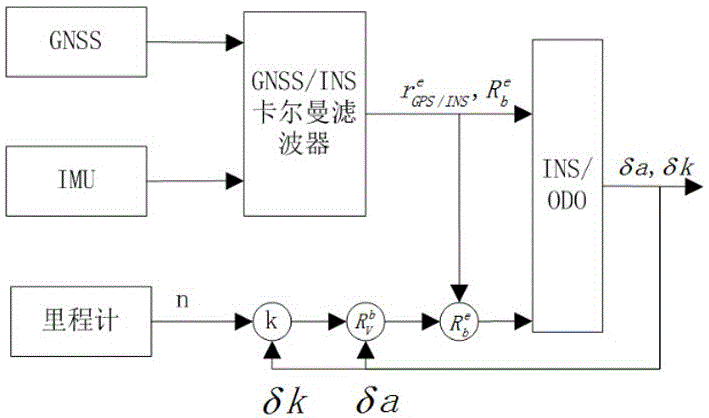
[0056] see Figure 1-Figure 2 , in an embodiment of the present invention, the GNSS / INS vehicle-mounted combined positioning and orientation algorithm based on the odometer to overcome satellite loss of lock, which includes correction of the odometer scale factor error when the GNSS / INS filter converges, the odometer coordinate system and the navigation coordinates The error angle correction is installed between them; when the GNSS satellite data is lost, the odometer corrects each error item in the IMU.

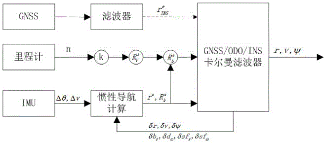
[0057] The specific operation steps are as follows: GNSS / INS and INS / ODO two-stage Kalman filter cascade structure

[0058] The premise of using the formula to correct the scale factor and installation error angle is that the IMU is fully calibrated. At this time, the installation error angle and scale factor have nothing to do with the INS navigation error. Therefore, the filter in this paper adopts a two-stage Kalman filter cascade design, as shown in figure 1 As shown, t...


PUM


Abstract

The invention discloses an odometer-based GNSS/INS (Global Navigation Satellite System/Inertial Navigation System) vehicle-mounted combined positioning and orientation algorithm for overcoming satellite locking loss. A position and a speed are calculated by GNSS data and an inertial navigation system, the difference value between the two serves as a measurement observation value for a Kalman filter, and each condition amount is fed back and corrected; the odometer is used for correcting each condition amount in an IMU (Inertial Measurement Unit), an INS/ODO combined method is used, summation and subtraction are carried out on an IMU output amount and the output value of the odometer during a filter time period to correct a scale factor of the odometer and a mounting error angle between an odometer coordinate system and a navigation coordinate system. In the case of GNSS satellite locking loss, the odometer corrects each error item in the IMU, which is particularly helpful for enhancing the IMU independent navigation position precision. The algorithm is particularly suitable for being applied in urban canyons where signal locking loss phenomena are likely to happen as GNSS satellite signals are blocked, and the overall system can keep a high-precision positioning result.

Description

technical field [0001] The invention relates to a high-precision vehicle-mounted combined positioning and orientation system, in particular to an odometer-based GNSS / INS vehicle-mounted combined positioning and orientation algorithm for overcoming the loss of satellite lock. Background technique [0002] Compared with the GNSS / INS real-time integrated navigation, the GNSS / INS combined positioning and attitude determination in the survey field has the characteristics of high position and attitude accuracy and post-processing. GNSS (GlobalNavigationSatelliteSystem, global satellite navigation system) works in differential mode, uses carrier phase observations to solve the ambiguity of the whole cycle and obtains centimeter-level position information, IMU (Inertial measurement unit, inertial measurement unit) provides attitude information and provides carrier during GNSS loss of lock. continuous location information. However, in areas with poor reception conditions of navigati...

Claims


Application Information

Patent Timeline
Patent Type & Authority Applications(China)
IPC IPC(8): G01S19/49G01S19/48
CPCG01S19/49G01S19/48
Inventor 孙红星丁学文王晖
Owner WUHAN GEOSUN NAVIGATION TECH CO LTD
Why Eureka
Try Eureka