CORS reference station network baseline ambiguity resolving method considering troposphere influence

A reference station and ambiguity technology, applied in radio wave measurement systems, satellite radio beacon positioning systems, measurement devices, etc., can solve the problems of decreased search efficiency and accuracy, search inaccuracy, etc.

Active Publication Date: 2016-08-10
WUHAN GEOSUN NAVIGATION TECH CO LTD
View PDF5 Cites 18 Cited by
  • Summary
  • Abstract
  • Description
  • Claims
  • Application Information

AI Technical Summary

Problems solved by technology

For example, Dr. Gao Xingwei proposed in 2002 that in the network RTK reference station single-epoch ambiguity resolution algorithm, the relevant information between L1 / L2 is used to search for L1 ambiguity, and the tropospheric error is calculated using a model. Make the search inaccurate to a certain extent, resulting in a decrease in search efficiency and accuracy

Method used


Image

  • CORS reference station network baseline ambiguity resolving method considering troposphere influence
  • CORS reference station network baseline ambiguity resolving method considering troposphere influence
  • CORS reference station network baseline ambiguity resolving method considering troposphere influence

Examples


Embodiment 1

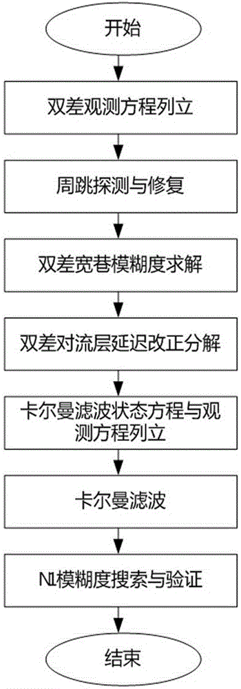
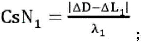
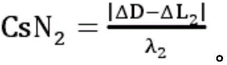
[0055] see figure 1 , in an embodiment of the present invention, a CORS reference station network baseline ambiguity resolution method that takes into account the influence of the troposphere, the GNSS data involved includes the GNSS data corresponding to the GPS of the United States, the GLONASS of Russia, and the BDS of China, etc., Hard disk can be used for data storage. The present invention can adopt computer to carry out algorithm realization when concrete implementation, and its specific realization process sees figure 1 , mainly includes: according to the received GNSS dual-frequency data collected by the geodetic receiver, eliminate the gross error in the GNSS dual-frequency data, and set up the double-difference observation equation; through the fact that the coordinates of the reference station in the network RTK are known, use The real distance from the satellite to the receiver is used to detect and repair cycle slips; the wide-lane ambiguity is solved by using M...


PUM


Abstract

The invention discloses a CORS reference station network baseline ambiguity resolving method considering a troposphere influence. The method is characterized by through dual-frequency data collected by a geodesic receiver, establishing a GNSS double difference observation equation; using a real distance from a satellite to the receiver to carry out detection and repairing of cycle slip; through using a MW combination observation value, carrying out solving and verification of wide-lane ambiguity; through writing troposphere delay errors of two ends of a baseline into a product of a projection function and site zenith troposphere delay, establishing a Kalman filtering observation equation and establishing a Kalman filtering state equation; through smoothing a Kalman filter, filtering a floating point value of L1 integer cycle ambiguity; searching the L1 integer cycle ambiguity floating point value acquired through the Kalman filtering; and verifying the searched L1 integer cycle ambiguity. In the invention, a characteristic that a base station coordinate in a network RTK is accurate and known is fully used, high precision is possessed and small cycle slip can be detected and repaired.

Description

technical field [0001] The invention relates to the field of GNSS integer ambiguity resolution, in particular to a CORS reference station network baseline ambiguity resolution method taking into account the influence of the troposphere. Background technique [0002] The CORS system broadcasts navigation signal corrections and auxiliary positioning signals through the ground communication system, and provides users with centimeter-level to sub-meter-level precision positioning and public terminal auxiliary enhancement services. The primary condition for the CORS system to achieve high-precision dynamic positioning is the integration of reference stations Accurate determination of the surrounding ambiguity. In the CORS system, the technology used is called network RTK technology. In network RTK technology, the determination of baseline ambiguity between reference stations is its core technology. Since the baseline lengths of network RTK reference stations are generally more ...

Claims


Application Information

Patent Timeline
Patent Type & Authority Applications(China)
IPC IPC(8): G01S19/44
CPCG01S19/44
Inventor 孙红星王晖赵存洁
Owner WUHAN GEOSUN NAVIGATION TECH CO LTD
Why Eureka
Try Eureka