Submerged line tracking method for flood evolution simulation in complicated river channel landform area

A technology of river basin flood evolution and submerged line, which is applied in the field of river flood evolution visualization, can solve problems such as inconsistency in spatial behavior, real-time flood submersion and advancement of evolution process, difficulty in dynamic simulation, and reduced practical value of flood evolution simulation system, so as to achieve dynamic recognition effect

Inactive Publication Date: 2016-08-10
CHINA INST OF WATER RESOURCES & HYDROPOWER RES
View PDF3 Cites 59 Cited by
  • Summary
  • Abstract
  • Description
  • Claims
  • Application Information

AI Technical Summary

Problems solved by technology

Due to the interaction and mutual influence of flood and terrain, the river channel and submerged area have great uncertainty. , The spatial behavior of the dynamic riverbed has caused great difficulties to the real-time and dynamic simulat

Method used


Image

  • Submerged line tracking method for flood evolution simulation in complicated river channel landform area
  • Submerged line tracking method for flood evolution simulation in complicated river channel landform area
  • Submerged line tracking method for flood evolution simulation in complicated river channel landform area

Examples


Embodiment 1

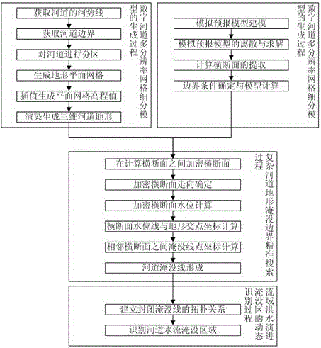
[0042] This embodiment is a submerged line tracking method for virtual simulation of water flow evolution in complex river topography. The content of the method described in this embodiment includes: 1. The generation process of the multi-resolution grid subdivision model of the digital river channel; 2. The flood evolution of the watershed The modeling and calculation of the simulation forecast model of the state; 3. The precise search method of the submerged boundary of the complex river topography; 4. The dynamic identification of the submerged area of ​​the river basin flood evolution. The overall technical process is as figure 1 shown.

[0043] 1. The generation process of the digital river multi-resolution grid subdivision model:

[0044] (1) Steps to obtain the river regime line of the river:

[0045] According to the distribution and characteristics of river water bodies in the study area, one or more satellite remote sensing data sources from GF-1, GF-2, Landsat TM / ...

Embodiment 2

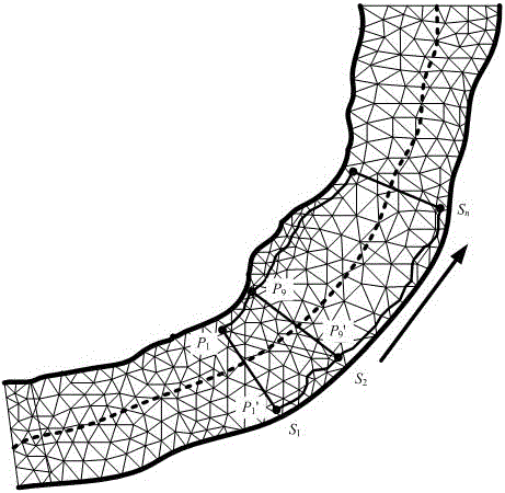
[0108] This embodiment is an improvement of the first embodiment, and is a refinement of the steps of the first embodiment regarding the calculation of the coordinates of the submerged line points between adjacent cross sections. The connection surface generalized in the step of calculating the coordinates of submerged line points between adjacent cross-sections in this embodiment is a folding surface composed of two triangular inclined planes.

[0109] by figure 2 with image 3 Combined, the water surface between adjacent sections can be generalized into a surface composed of two triangles, indicating that the adjacent section S 1 and S 2 Searches between submerged lines.

[0110] According to S 1 The position of the section, determine the triangular unit it may pass through; then according to the section S 2 Determine the triangle elements it passes through. Downstream Section S 1 The two water surface points and the upstream section S 2 A water surface point of , c...

Embodiment 4

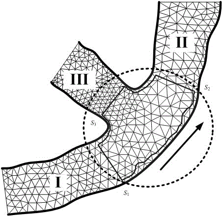
[0112] This embodiment is an improvement of the first embodiment, and is a refinement of the steps of the first embodiment regarding the calculation of the coordinates of the submerged line points between adjacent cross sections. The connection surface generalized in the step of calculating the coordinates of submerged line points between adjacent cross-sections in this embodiment is a folded surface composed of an inclined plane and a horizontal plane.

[0113] This embodiment is a supplement to Embodiment 1. In the river boundary search method based on simulated forecast water level, except S 1 and S 2 In addition to being generalized into two triangular oblique planes, the sections can also be generalized into an oblique plane and a horizontal plane, so that figure 2 to illustrate. From upstream section S 1 Nearest downstream section S 2 starting point P 9 Lead out the auxiliary section S parallel to the upstream section 2 ′, section S 1 and S 2 ’ On the same space...


PUM


Abstract

The invention relates to a submerged line tracking method for flood evolution simulation in a complicated river channel landform area. The submerged line tracking method comprises four process of generating a digital river channel multi-resolution grid segmentation model; modeling and computing a simulation forecast model for a drainage area flood evolution state, wherein the process is operated in parallel with the process of generating the digital river channel multi-resolution grid segmentation model; accurately searching the submerging boundary of the complicated river channel landform; and dynamically identifying a drainage area flood evolution submerged area. The submerged line tracking method performs accurate searching on the submerging boundary of the complicated river channel landform through establishing the digital river channel multi-resolution grid segmentation model and the simulation forecast model, thereby realizing dynamic identification on the drainage area flood evolution submerged area, accurately simulating complicated river channels at various landforms, and quickly simulating a flood submerged area. Quick, accurate and visual forecast on time, water depths and flow and even flow velocity in flood evolution to different river segments are realized. A scientific basis is laid for disaster prevention and mitigation operation before flooding.

Description

technical field [0001] The invention relates to a submerged line tracking method for virtual simulation of flood evolution in complex river topography basins, a method for calculating hydrological calculations using computing technology, in particular to a visualization method for river flood evolution, which is a method that can intuitively express river flood submersion state, and methods to improve the disaster prevention and mitigation capacity of the watershed. Background technique [0002] Watershed flood evolution simulation is an important part of the construction of decision support system for flood control non-engineering measures. It is based on computer graphics and virtual The inundation of the area within the watershed is simulated dynamically and in real time in a computer-generated virtual environment. Centered on user experience, it is convenient for all-round observation, operation and analysis of the phenomenon and law of flood evolution in the basin, bet...

Claims


Application Information

Patent Timeline
IPC IPC(8): G06T17/05
CPCG06T17/05
Inventor 冶运涛梁犁丽尚毅梓蒋云钟龚家国张双虎张海涛张象明
Owner CHINA INST OF WATER RESOURCES & HYDROPOWER RES
Why Eureka
Try Eureka