
A non -ground reference method based on GNSS/MEMS positioning orientation

A triangulation and ground technology, applied in the directions of measuring devices, photogrammetry/video metrology, surveying and navigation, etc., can solve problems such as short battery life of UAVs, large lateral overlap, and susceptibility to airflow , to achieve the effect of increasing the maximum flight area, reducing side overlap and improving work efficiency

Active Publication Date: 2018-09-28
WUHAN GEOSUN NAVIGATION TECH CO LTD
View PDF3 Cites 0 Cited by
  • Summary
  • Abstract
  • Description
  • Claims
  • Application Information

AI Technical Summary

Problems solved by technology

[0002] Traditional aerial photogrammetry is mostly used to solve the small-scale mapping of large areas. In view of the problem of large-scale mapping of small areas that has emerged in the field of measurement in recent years, if conventional aerial photography is still used, it often results in high cost, poor maneuverability, and It is greatly affected by the weather, so low-altitude triangulation technology based on low-altitude unmanned aerial vehicles and conventional digital cameras has become a hot issue in the field of photogrammetry in recent years
Usually, the data acquisition devices used are generally low-altitude photography platforms (UAVs, unmanned airships, etc.) and ordinary multi-lens integrated small data cameras. Influenced by the influence of the flight path, it is difficult to maintain the route and the degree of curvature is large, the rotation angle of the photo is larger than that of the conventional aerial photogrammetry, and the regularity of the overlapping degree of the image is small; 23.7mm×15.6mm, the Canon 5D camera’s image size is 35.8mm×23.9mm), the number is large, the inclination angle of the image is too large (according to statistics, the κ angle is between ±35 degrees), and the overlap is irregular (there is a heading Overlap ≤ 30%, side overlap ≤ 20%) and other issues, the corresponding ground coverage is limited
This results in that the number of photos in the same measurement area will be more than the number of photos in conventional aerial triangulation, and the number of photo connection points in encryption will also be more than conventional aerial triangulation. If the ground image control points are still arranged according to the requirements of the traditional aerial angle measurement, the workload of the field and office will be greatly increased.
[0003] On the other hand, the lateral overlap of the images during the aerial photography of the UAV is generally relatively large, and the battery life of the UAV itself is relatively short, which further reduces the area of ​​​​the UAV during one flight.
[0004] In order to check the attitude state of the aircraft in real time, MEMS (Micro-Electro-Mechanical System, Micro-Electro-Mechanical System) sensors are installed on the general aircraft, and the data collected by the three-axis gyro device and the three-axis accelerometer device are sent to the The flight control system calculates the attitude angle of the aircraft. The accuracy of this attitude angle is generally very low and cannot be directly used to replace the outer azimuth element of the image. In addition, the flight control system usually does not store IMU data, so it cannot pass the measurement. Processing method to improve the measurement accuracy of attitude angle

Method used


Image

  • A non -ground reference method based on GNSS/MEMS positioning orientation
  • A non -ground reference method based on GNSS/MEMS positioning orientation
  • A non -ground reference method based on GNSS/MEMS positioning orientation

Examples


Embodiment 1

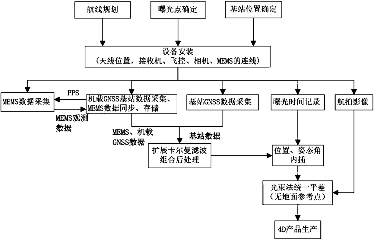
[0030] In the embodiment of the present invention, a low-altitude triangulation method based on GNSS / MEMS positioning and orientation without ground reference, the technical steps adopted include:

[0031] (1) According to the geographical parameters of the area to be surveyed and mapped, including location, shape, area, etc., draw the flight belt, exposure point location, etc. in the ground flight control system, and select the appropriate GNSS base station location.

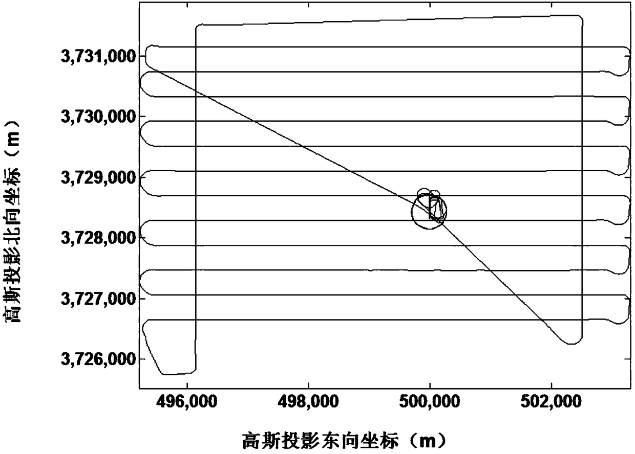
[0032] In order to reduce the layout of image control points in the survey area, it is usually necessary to fly several routes approximately perpendicular to the mapping route, that is, the frame route. Its main function is to play the role of elevation control points at both ends of the basic route, and to correct the coordinate system drift error of the GNSS camera station through the ground control scheme of the four-corner level height control point plus 2 vertical frame routes. On the basis of ensuring acc...


PUM


Abstract

The invention discloses a ground reference-free low altitude triangulation method based on GNSS / MEMS positioning and directioning. The method comprises combining GNSS and MEMS chips to obtain a combined chip module for synchronously acquiring and storing receiver data of a GNSS satellite and data transmitted through a MEMS sensor, carrying out post-observation processing and feedback compensation to obtain high precision position information and attitude angle information, acquiring a mapping coordinate system position through coordinate transforming software in a measurement zone, carrying out eccentricity correction and eccentric angle correction through the position information and attitude angle information as data of starting count, providing elements of exterior orientation for aerophotogrammetry and carrying out low altitude triangulation without ground control. The ground reference-free low altitude triangulation method reduces flight side overlap, improves work efficiency, reduces a cost, reduces outdoor work person workload in unmanned plane plotting and solves the problem that the existing unmanned plane plotting cannot guarantee a plotting precision through arrangement of a ground control point in an area with rough topography.

Description

technical field [0001] The invention relates to the field of low-altitude photogrammetry, in particular to a low-altitude triangulation method without ground reference based on GNSS / MEMS positioning and orientation. Background technique [0002] Traditional aerial photogrammetry is mostly used to solve the small-scale mapping of large areas. In view of the problem of large-scale mapping of small areas that has emerged in the field of measurement in recent years, if conventional aerial photography is still used, it often results in high cost, poor maneuverability, and The low-altitude triangulation technology based on low-altitude unmanned aerial vehicles and conventional digital cameras is a hot issue in the field of photogrammetry in recent years. Usually, the data acquisition devices used are generally low-altitude photography platforms (UAVs, unmanned airships, etc.) and ordinary multi-lens integrated small data cameras. Influenced by the influence of the flight path, it...

Claims


Application Information

Patent Timeline
Patent Type & Authority Patents(China)
IPC IPC(8): G01C11/00
CPCG01C11/00
Inventor 孙红星丁学文王晖
Owner WUHAN GEOSUN NAVIGATION TECH CO LTD
Learn More