

Lake water area information extraction method based on Landsat OLI multispectral image
A multi-spectral image and information extraction technology, applied in the field of lake water information extraction based on LandsatOLI multi-spectral images, can solve the problems of heavy workload, unclear distinction between water information and non-water information, and cumbersome post-classification processing. Workload, improve the efficiency of classification processing, improve the effect of accuracy and efficiency
- Summary
- Abstract
- Description
- Claims
- Application Information
AI Technical Summary
Problems solved by technology
Method used
Image

Examples
Embodiment
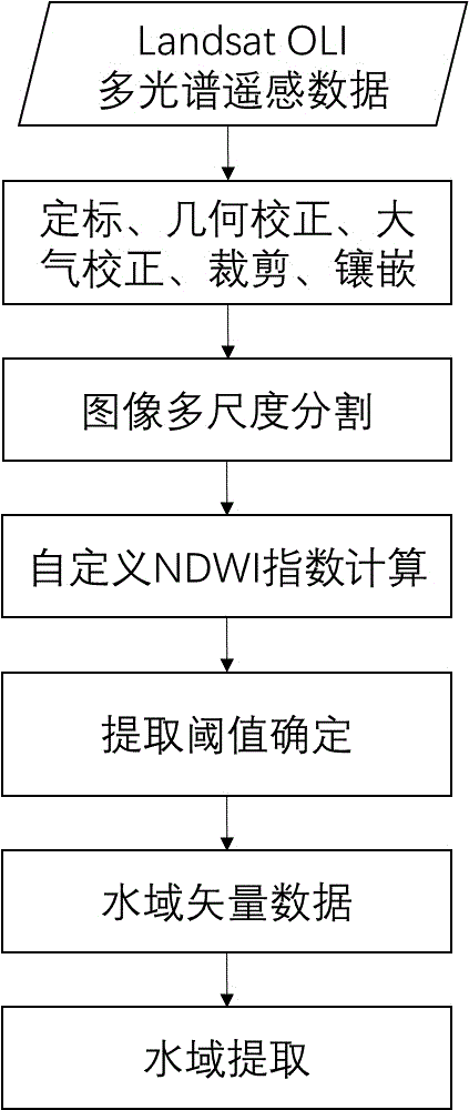
[0028] Example: such as figure 1 As shown, the following steps are used to obtain the water information data of the Hongze Lake area
[0029] (1) Use ENVI software to perform calibration, geometric correction, atmospheric correction, mosaic, and clipping preprocessing on the Landsat OLI multispectral data to be analyzed, including the following specific content:
[0030] (11) Use remote sensing image processing software to calibrate the original Landsat OLI data. If the number of remote sensing images is large, perform batch processing;
[0031] (12) Use remote sensing image processing software to fuse the multispectral data after calibration in step (11), and fuse the data of the 7 bands in sequence. If the number of remote sensing images is large, perform batch processing;
[0032] (13) For the fused data in step (12), perform clipping, framing, and mosaic processing according to the range of the target area to obtain complete multispectral data of the target area;
[0033...
PUM
 Abstract
Description
Claims
Application Information