Automatic 3D building model reconstruction method based on aviation LiDAR data

A building and data technology, applied in 3D modeling, image data processing, instruments, etc., can solve problems such as difficulty in determining the topological relationship of contour lines, and difficulty in determining the connection relationship between different roof layers.

Inactive Publication Date: 2016-10-12
NANJING UNIV +1
View PDF4 Cites 20 Cited by
  • Summary
  • Abstract
  • Description
  • Claims
  • Application Information

AI Technical Summary

Problems solved by technology

[0007] The technical problem to be solved by the present invention is: aiming at the problems that existing building reconstruction methods are mostly realized by extracting building contour lines, and the defects in contour line extraction and the topological relationship between contour lines are difficult to determine, the present invention provides An automatic 3D building model reconstruction method based on aerial LiDAR data, which can ensure the accuracy of roof patch segmentation, and use the internal points and edge points obtained by roof layer resampling to quickly and efficiently realize the relationship between different roof layers. The connection between different roof layers is reconstructed with high precision and the 3D model of the building is solved, which solves the problem that it is difficult to determine the connection relationship between different roof layers

Method used


Image

  • Automatic 3D building model reconstruction method based on aviation LiDAR data
  • Automatic 3D building model reconstruction method based on aviation LiDAR data
  • Automatic 3D building model reconstruction method based on aviation LiDAR data

Examples


Embodiment Construction

[0045] The present invention will be described in detail below according to the accompanying drawings, so as to make the technical route and operation steps of the present invention clearer.

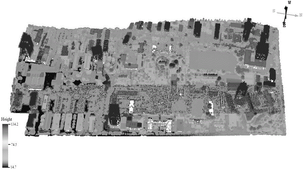
[0046] The aerial LiDAR data obtained by using the Optech ALTM Gemini laser scanner is experimental data, such as figure 2 shown. The average point spacing of aviation LiDAR data is 0.4m, the elevation accuracy is 15cm, and the plane accuracy is 30cm.

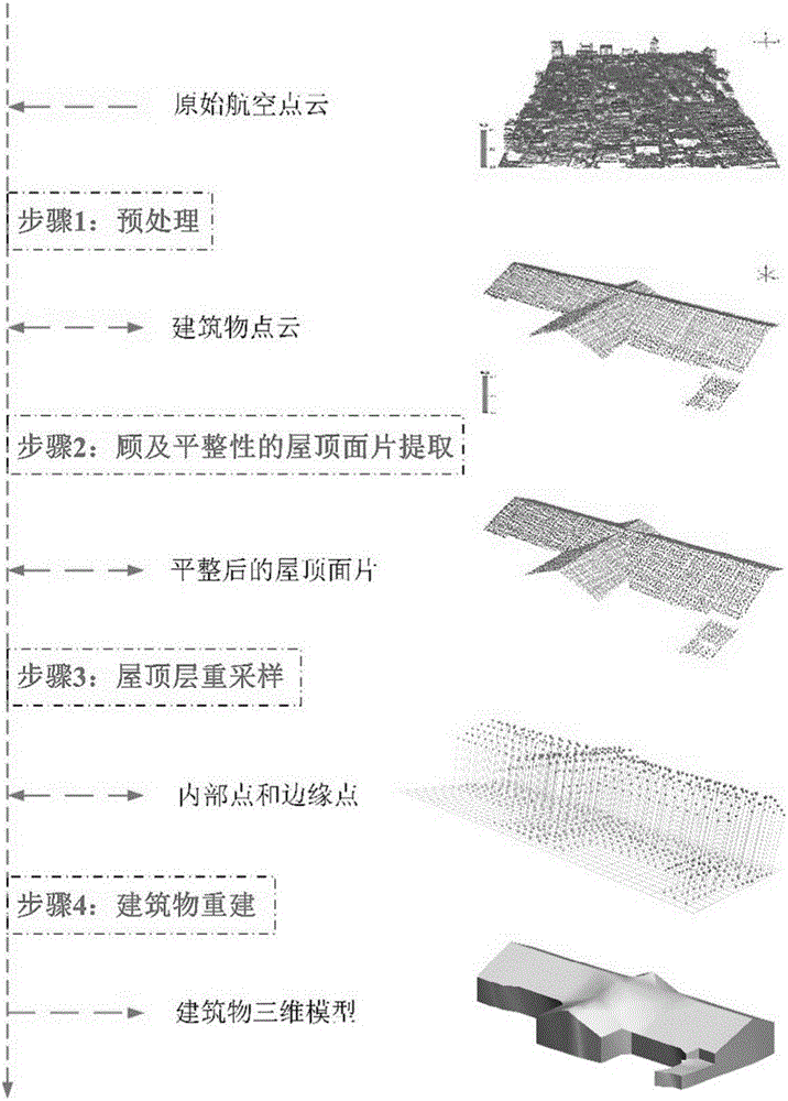
[0047] This embodiment is a method for automatic reconstruction of a three-dimensional building model based on aerial LiDAR data (see the flowchart in figure 1 ), including the following steps:

[0048] The first step is the point cloud extraction of building roofs - the types of ground objects contained in the original aerial LiDAR data are mainly buildings, vegetation and ground. The invention extracts building LiDAR point clouds based on the reverse iterative mathematical morphology filtering algorithm in the patent CN201110432421....


PUM


Abstract

The invention discloses an automatic 3D building model reconstruction method based on aviation LiDAR data. The method comprises steps of: extracting a building roof point cloud from the aviation LiDAR data by using reverse iteration mathematic morphological filtering and a method based on point cloud density; extracting and optimizing roof surface patches according to a strategy of seed area selection-roof surface patch growth-surface path smoothing and optimization; constructing 2D regular grids to resample different roof layers to obtain the internal points and the edge points of the roof layers; optimizing the edge points of different roof layers; connecting the internal points and the edge points of the roof layers to construct a building roof surface and wall surface so as to finally achieve 3D model reconstruction of the building roof. It has been proved by practices that the method may reconstruct the 3D model of a building roof, provides a new idea for connection among different roof layers, and has high 3D model reconstruction precision.

Description

technical field [0001] The invention relates to an automatic three-dimensional building model reconstruction method based on aerial LiDAR data, in particular to an automatic three-dimensional building model reconstruction method based on aerial LiDAR data using a smoothing strategy and interlayer connections. Background technique [0002] The 3D building model is an important means of expressing the 3D structure information of the building, and has a very wide range of applications in the fields of urban planning, disaster monitoring, communication facility construction and digital city. As the most important and challenging task in digital city construction, 3D model reconstruction of buildings has received great attention in the past decades. Using aerial stereo image pairs to obtain 3D models of buildings is a traditional photogrammetry method that is still widely used, but it requires more manual intervention and the degree of automation is not high. [0003] In recent ...

Claims


Application Information

Patent Timeline
Patent Type & Authority Applications(China)
IPC IPC(8): G06T17/05
CPCG06T17/05
Inventor 程亮许浩李满春王娅君谌颂魏晓燕袁一夏南孙越凡陈东
Owner NANJING UNIV
Why Eureka
Try Eureka