
Method of determining mining subsidence farmland destruction boundary based on subsidence parameters

A determination method and a technology of cultivated land, applied in the determination of the boundary of cultivated land damaged by coal mining subsidence, can solve problems such as the lack of theoretical support, and achieve the effects of promoting construction, solving conflicts between workers and farmers, and sustainable land development

Inactive Publication Date: 2016-11-09
CHINA UNIV OF MINING & TECH (BEIJING)
View PDF3 Cites 6 Cited by
  • Summary
  • Abstract
  • Description
  • Claims
  • Application Information

AI Technical Summary

Problems solved by technology

Qi Jiazhong proposed to use the influence angle of cultivated land damage to determine the scope of coal mining subsidence, but the boundary of cultivated land damage comes from work experience and lacks theoretical support

Method used


Image

  • Method of determining mining subsidence farmland destruction boundary based on subsidence parameters
  • Method of determining mining subsidence farmland destruction boundary based on subsidence parameters
  • Method of determining mining subsidence farmland destruction boundary based on subsidence parameters

Examples


Embodiment

[0035] This example is a high-water-level mining area in the North China Plain. The coal seam in the mining area is gentle, with a dip angle of generally 2-13° and a simple structure. The average buried depth of the coal seam is 240m-460m, and the thickness of the coal seam is about 28.3m. The terrain in the mine field is flat, and the ground elevation varies between +44m and +52m, gradually decreasing from northeast to southwest, and the slope is extremely gentle.

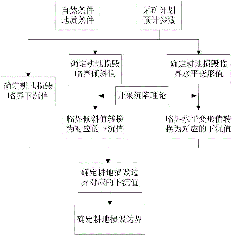
[0036] The method for determining the boundary of cultivated land damage in coal mining subsidence based on subsidence parameters in this embodiment, the steps are as follows figure 1 shown, including:

[0037] 1) Obtain the natural conditions, geological conditions, mining plan and estimated parameter information of the area where the research area is located: obtain the natural conditions, geological conditions, mining plan and estimated parameters of the area by collecting natural, geological, mining and other ...


PUM


Abstract

The invention relates to a method of determining a mining subsidence farmland destruction boundary based on subsidence parameters, which belongs to the technical field of mining, land use and land reclamation. The method comprises steps: natural conditions, geological conditions, mining plans and estimated parameter information of an area where a mining area is are acquired; a mining subsidence estimation system is adopted for ground subsidence simulation, and a mining area surface subsidence contour and the maximum subsidence value are acquired; based on a mining subsidence theory, critical subsidence values corresponding to three subsidence parameters of subsidence, inclination and horizontal deformation are determined firstly, and the subsidence value corresponding to the farmland destruction boundary is then determined; and according to the subsidence value corresponding to the farmland destruction boundary and the surface subsidence contour, the farmland destruction boundary is determined. The method provides a reference basis for compilation for land compensation, use and land reclamation and plays an important role in reasonably solving contradiction between workers and peasants and promoting sustainable land development.

Description

technical field [0001] The invention belongs to the technical fields of mining technology, land utilization and land reclamation, and in particular relates to a method for determining the boundary of cultivated land damage in coal mining subsidence based on subsidence parameters. Background technique [0002] Our country has a lot of people and little land, and the arable land resources are very tight. However, the large-scale mining of coal resources has caused large-scale damage to the arable land resources, which seriously threatens my country's food security and restricts the sustainable development of mining areas. Especially in the mining areas with high water level in the central and eastern parts of my country, the water accumulation is serious after the land subsidence, and a large area of ​​high-quality farmland has been reduced to water, which cannot be used rationally. Article 32 of the "Coal Law of the People's Republic of China" stipulates: If coal mining occup...

Claims


Application Information

Patent Timeline
Patent Type & Authority Applications(China)
IPC IPC(8): G06Q50/02G06F19/00
CPCG06Q50/02G16Z99/00
Inventor 胡振琪陈慧玲赵艳玲黄琴焕
Owner CHINA UNIV OF MINING & TECH (BEIJING)
Learn More