Multiresolution CNN-based millimeter-wave radar cloud map segmentation method

A millimeter-wave radar, multi-resolution technology, applied in neural learning methods, image enhancement, image analysis, etc., can solve problems such as insufficient segmentation accuracy and complex pre-processing

Inactive Publication Date: 2016-11-16
BEIJING UNIV OF TECH
View PDF2 Cites 48 Cited by
  • Summary
  • Abstract
  • Description
  • Claims
  • Application Information

AI Technical Summary

Problems solved by technology

[0007] To sum up, the existing cloud image segmentation algorithms require complex pre-processing, manual extraction of features for segmentation or segmentation through threshold judgment, etc. These methods can only be used for small-scale cloud image processing, and the segmentation Accuracy is not high enough

Method used


Image

  • Multiresolution CNN-based millimeter-wave radar cloud map segmentation method
  • Multiresolution CNN-based millimeter-wave radar cloud map segmentation method
  • Multiresolution CNN-based millimeter-wave radar cloud map segmentation method

Examples


Embodiment Construction

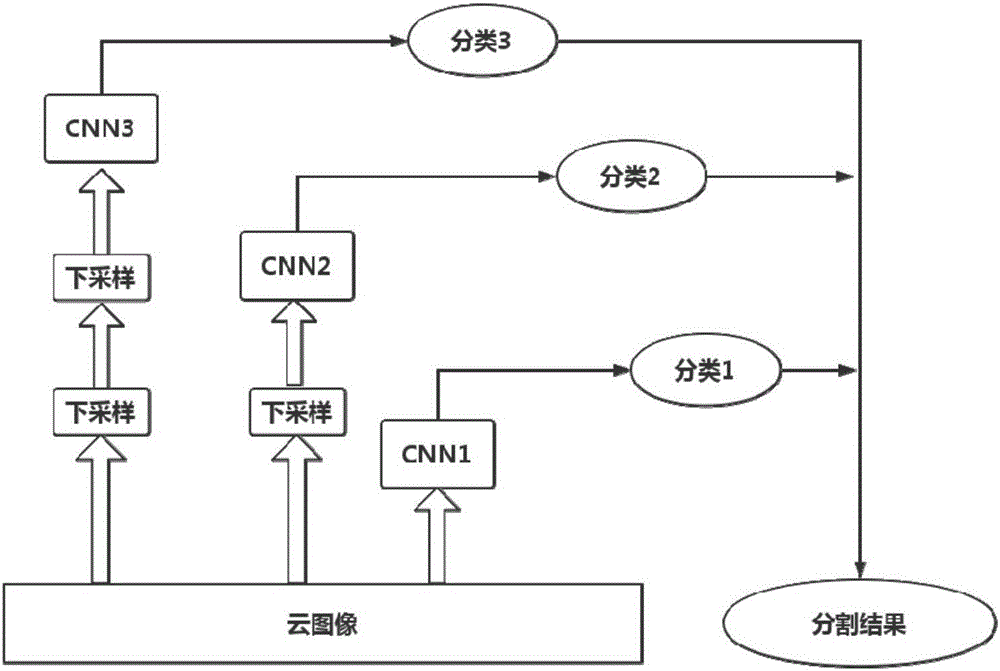
[0067] In order to achieve the above problems, the present invention provides a cloud image segmentation method based on multi-resolution CNN (MR-CNN). The present invention will be further described in detail below in conjunction with the accompanying drawings.

[0068] 1. Image preprocessing

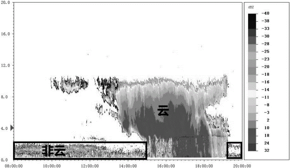
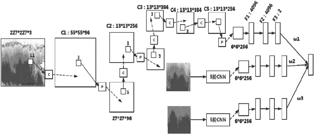
[0069] The picture preprocessing of the present invention mainly has two aspects. One is that we need to manually mark the groundtruth of the cloud image (because there is no public data set in the field of cloud image processing, so we need to generate the groundtruth by ourselves, the manual labeling here is different from the traditional manual extraction of features, only need to mark dozens of Frame, the testing stage just can be automatically divided) as the supervisory signal when training CNN network; The 2nd, consider the feature that the information of combining context is more conducive to learning cloud image, the present invention needs to cut out the image area of ​​differ...


PUM


Abstract

The invention discloses a multiresolution CNN-based millimeter-wave radar cloud map segmentation method, and belongs to the field of image segmentation. The method comprises the following steps of: obtaining a high-temporal-spatial resolution cloud evolution map of a horizontal/vertical structure by utilizing millimeter wave cloud radar, wherein the information of a context of the cloud map is fully utilized; learning local and global features of the cloud map through respectively inputting three image areas with different resolutions into three CNN networks configured with same parameters; classifying the learned features into cloud features and non-cloud features through classifiers of the neural networks, so as to realize the segmentation of the cloud map; and finally combining the segmentation results of the three networks so as to ensure that the segmentation correctness of the cloud map is up to 99.67%.

Description

technical field [0001] The invention belongs to the field of image segmentation, and specifically relates to biological feature extraction and classification. A cloud image segmentation method based on multi-resolution CNN (MR-CNN) is proposed by using millimeter-wave cloud radar to obtain cloud evolution maps with high spatio-temporal resolution in horizontal and vertical structures. Background technique [0002] Clouds are water droplets, supercooled water droplets, ice crystals, or their mixtures formed by condensed water vapor in the atmosphere, suspended in the air, and sometimes contain some larger raindrops, ice particles, and snow crystals. It is a common weather phenomenon. . Cloud observation is an important part of ground observation. Accurate cloud observation can provide varying degrees of help for weather forecasting, flight safety, and artificial rainfall enhancement operations. At present, the information of cloud observation data is obtained mainly through...

Claims


Application Information

Patent Timeline
Patent Type & Authority Applications(China)
IPC IPC(8): G06T7/00G06N3/08
CPCG06N3/08G06T2207/10044
Inventor 毋立芳贺娇瑜张加楠马玉琨张世杰
Owner BEIJING UNIV OF TECH
Why Eureka
Try Eureka