
Peripheral target geographic information acquiring and searching method for position service

A geographic information and location service technology, applied in the field of geographic information acquisition and search of surrounding targets, can solve the problems of no public corporate geographic information search platform, no users to provide search and discovery, and focus on corporate search, etc. Guaranteed time and calculation amount, enriching the effect of application scenarios

Inactive Publication Date: 2017-01-18
成都数联铭品科技有限公司
View PDF4 Cites 19 Cited by
  • Summary
  • Abstract
  • Description
  • Claims
  • Application Information

AI Technical Summary

Problems solved by technology

[0004] The existing public geographic information map system does not have a public search platform dedicated to corporate geographic information, only hotels, restaurants, scenic spots, etc.; a large and comprehensive general search does not highlight the significance of focusing on corporate search
In addition, in all kinds of geographic information system applications, geographic information services and applications based on user locations have high commercial value; users search for useful target information around them according to their own locations, which provides users with great convenience; but currently Location-based services are mainly focused on fast consumption and service industries, and do not provide users with location-based search and discovery related applications for enterprises

Method used


Image

  • Peripheral target geographic information acquiring and searching method for position service
  • Peripheral target geographic information acquiring and searching method for position service
  • Peripheral target geographic information acquiring and searching method for position service

Examples


Embodiment 1

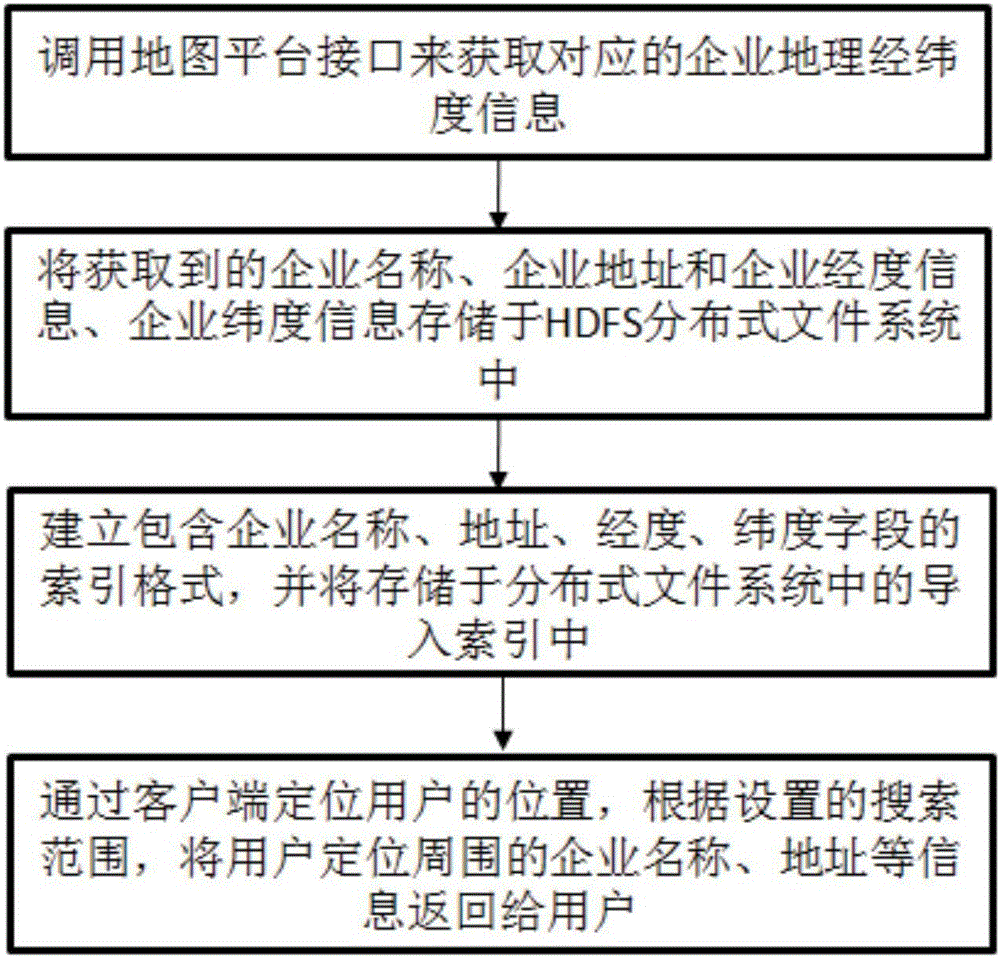
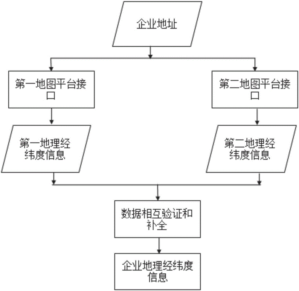
[0064] Call the public map platform according to the address of each enterprise to obtain the longitude and latitude information of the enterprise; for example, the name is Chengdu ABCD Technology Co., Ltd., and the address is: No. xx, the middle section of Tianfu Avenue, Chengdu, and the target address is obtained by calling the interface of the first map platform according to the address information The corresponding geographic latitude and longitude information is: {″status”: 0, “result”: {″location”: {″lng”: 105.07392899855, “lat”: 36.555138880016}, “precise”: 1, “confidence”: 80,” level": "\u5546\u52al\u5927\u53a6"}} From the returned information, it can be obtained that the reliability is: 80, the longitude is 105.07392899855, and the latitude is 36.555138880016.

[0065] Call the second map platform interface to obtain the geographic latitude and longitude information corresponding to the target address: {"status": "1", "info": "OK", "infocode": "1000", "count": "1", "g...


PUM


Abstract

The invention relates to the Internet information processing field and particularly relates to a peripheral target geographic information acquiring and searching method for position service. The location position of a user is positioned through a client, the enterprise information within a set user positioning surrounding scope is returned to the user. According to the method, data analysis, integration and display is carried out for enterprises, based on that the full basic enterprise information is established and the latitude / longitude data is stored, the enterprise information near the user is returned to the user through combining a field search function of a positioning and index system of the user, a problem of insufficient enterprise searching existing in position service in the prior art is solved, and technical support is provided for related business application and analysis, moreover, when peripheral enterprise searching is carried out, to-be-displayed enterprises are searched in a largest longitude / latitude deviation scope acquired through preselected distance conversion, actual distances between the enterprises and the user are calculated on the basis of the searched enterprises, the enterprises within a search radius is remained, efficiency and accuracy requirements are satisfied in a pre-screening mode.

Description

technical field [0001] The invention relates to the field of Internet information processing, in particular to methods for acquiring and searching geographical information of surrounding objects for location services. Background technique [0002] With the social progress represented by the development of information technology, the accumulation of data information is increasing at a series rate. The large amount of data and low value density are the problems that plague the mining and utilization of such massive data information. In the massive data, how to accurately obtain people's attention Information has become an urgent problem to be solved. In the face of huge market demand, Internet search and big data analysis have become popular in today's Internet applications; various search engines have also emerged, among which vertical search engines are professional search engines for a certain industry Compared with general search engines, which have a large amount of infor...

Claims


Application Information

Patent Timeline
Patent Type & Authority Applications(China)
IPC IPC(8): H04L29/08H04W4/02G06F17/30
CPCH04W4/02G06F16/29G06F16/9537H04L67/52
Inventor 盛云范从俊谢懿
Owner 成都数联铭品科技有限公司
Learn More