Automatic surveying and mapping system and surveying and mapping method for vehicle-mounted cultivated land topography

An automatic measurement and terrain technology, applied in surveying and navigation, radio wave measurement system, satellite radio beacon positioning system, etc., can solve the problems of complex topographic information measurement of cultivated land, high measurement cost and low efficiency, and achieve the reduction of measurement cost , Improving measurement efficiency and improving the accuracy of surveying and mapping

Active Publication Date: 2017-02-15
NORTHEAST AGRICULTURAL UNIVERSITY
View PDF12 Cites 5 Cited by
  • Summary
  • Abstract
  • Description
  • Claims
  • Application Information

AI Technical Summary

Problems solved by technology

[0005] In order to solve the problems of complex agricultural land terrain information measurement, low efficiency, and high measurement cost, realize fast and efficient real-time surveying and mapping of cultivated land terrain, and keep up with the development of precision agriculture in my country, the invention provides a vehicle-mounted agricultural land terrain automatic surveying and mapping system and surveying methods

Method used


Image

  • Automatic surveying and mapping system and surveying and mapping method for vehicle-mounted cultivated land topography
  • Automatic surveying and mapping system and surveying and mapping method for vehicle-mounted cultivated land topography
  • Automatic surveying and mapping system and surveying and mapping method for vehicle-mounted cultivated land topography

Examples


Embodiment Construction

[0022] In order to make the object, technical solution and advantages of the present invention more clear, the present invention will be further described in detail below in conjunction with the accompanying drawings and embodiments. It should be understood that the specific implementation examples described here are only used to explain the present invention, and are not intended to limit the present invention.

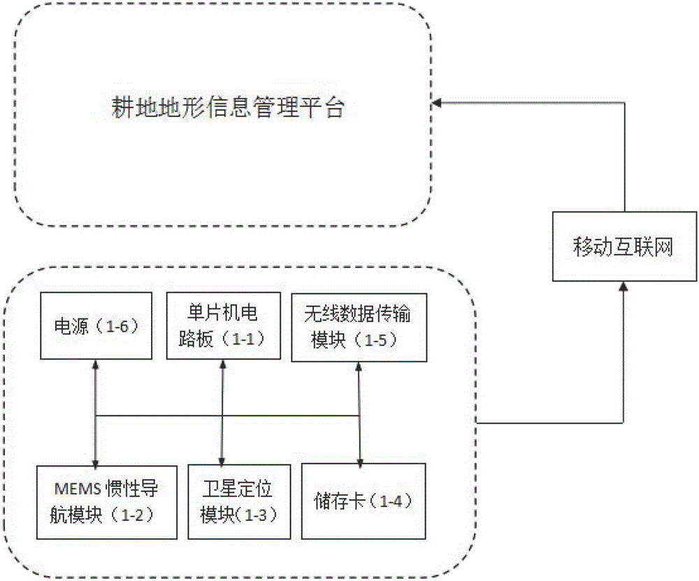
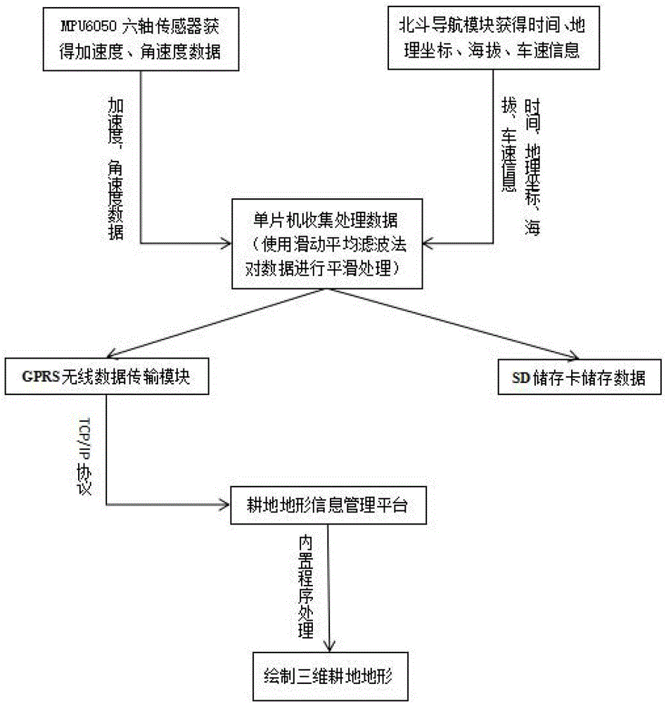
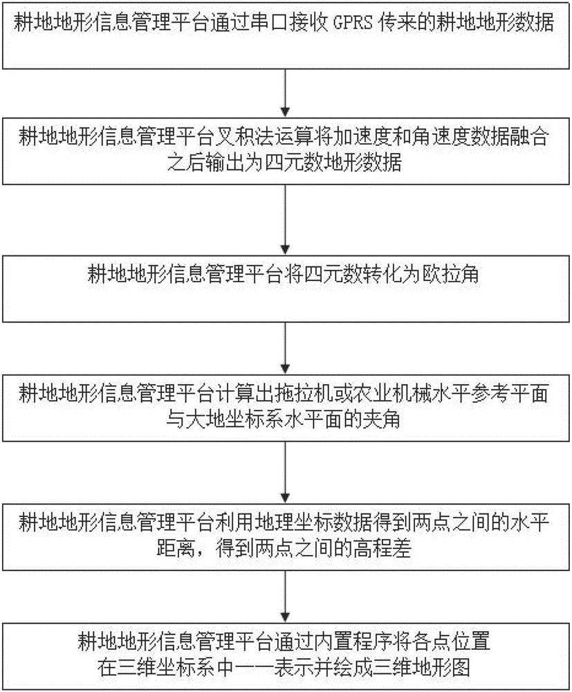
[0023] Vehicle-mounted cultivated land terrain automatic surveying and mapping system includes vehicle-mounted cultivated land topography automatic measurement device and cultivated land topography information management platform; among them, cultivated land topography automatic measurement device consists of single-chip circuit board, MEMS inertial navigation module, satellite positioning module, memory card, wireless data transmission module and power supply System composition; the single-chip circuit board of the present invention is a MCS51 series single-chip micr...


PUM


Abstract

The invention discloses an automatic surveying and mapping system and an automatic surveying and mapping method for vehicle-mounted cultivated land topography. The automatic surveying and mapping system for the vehicle-mounted cultivated land topography comprises a vehicle-mounted cultivated land topographic information automatic measuring device and a cultivated land topographic information management platform, wherein the vehicle-mounted cultivated land topographic information automatic measuring device is composed of a protective cover, a single-chip microcomputer circuit board, an MEMS (Micro-electromechanical Systems) inertial navigation module, a satellite positioning module, a wireless data transmission module, a liquid crystal display, a control button and a power supply. The automatic surveying and mapping method for the vehicle-mounted cultivated land topography comprises the following steps: the topographic information automatic measuring device, which is mounted on an agricultural machine, automatically acquires cultivated land topographic data in real time when the agricultural machine works, and sends the data to the cultivated land topographic information management platform through the wireless data transmission module; the platform processes and displays the cultivated land topographic information in real time. According to the automatic surveying and mapping system and the automatic surveying and mapping method for the vehicle-mounted cultivated land topography, the problems that the cultivated land topography is rapidly and efficiently measured in real time and automatically drawn are well solved.

Description

technical field [0001] The invention relates to an agricultural cultivated land terrain surveying and mapping system and surveying and mapping method, in particular to a vehicle-mounted cultivated land terrain automatic surveying device and surveying and mapping method. Background technique [0002] Cultivated land is the basis and guarantee for human survival and an important resource for regional development. The topography of cultivated land not only affects the spatial distribution of cultivated land, but also affects the quality of cultivated land, which is a crucial existence in cultivated land information. However, there are still many problems in the surveying and mapping of cultivated land topography. [0003] At this stage, the topography of cultivated land is mainly measured by radar or laser, but there are problems in the survey and mapping of cultivated land at this stage, such as bulky equipment, complicated installation, low surveying and mapping efficiency, ...

Claims


Application Information

Patent Timeline
Patent Type & Authority Applications(China)
IPC IPC(8): G01C23/00G01S19/14
CPCG01C23/00G01S19/14
Inventor 刘立意张宝鹏唐金科李晋汪雨晴刘冬梅
Owner NORTHEAST AGRICULTURAL UNIVERSITY
Why Eureka
Try Eureka