A single-satellite autonomous orbit determination method using on-satellite push-broom remote sensing image information

A remote sensing image and image technology, applied in the field of satellite orbit determination research, can solve problems such as low orbit determination accuracy, damage to space-based orbit determination systems, and interference, and achieve the effects of guaranteed accuracy, improved autonomous operation performance, and increased reliability.

Active Publication Date: 2019-04-09
SHANGHAI AEROSPACE CONTROL TECH INST
View PDF5 Cites 0 Cited by
  • Summary
  • Abstract
  • Description
  • Claims
  • Application Information

AI Technical Summary

Problems solved by technology

However, it is easy to find that the space-based orbit determination system still relies on the ground measurement and control station for its own orbit determination, and its own orbit determination error will inevitably be introduced into the remote sensing satellite orbit determination, and with the development of anti-satellite technology, space-based orbit determination The system is at risk of being destroyed and interfered with at any time
In order to avoid interference and ensure full arc coverage, it is necessary to develop satellite full autonomous orbit determination technology. At present, there are two methods: using star sensors and horizons to measure starlight elevation angles, which are only used in low-Earth orbits, and fixed low orbit accuracy; or use the starlight refraction method to indirectly measure the orbit after the horizon is sensitive, this method is in the theoretical stage, and there is still a distance from practical application

Method used


Image

  • A single-satellite autonomous orbit determination method using on-satellite push-broom remote sensing image information
  • A single-satellite autonomous orbit determination method using on-satellite push-broom remote sensing image information
  • A single-satellite autonomous orbit determination method using on-satellite push-broom remote sensing image information

Examples


Embodiment Construction

[0027] The present invention will be further elaborated below by describing a preferred specific embodiment in detail in conjunction with the accompanying drawings.

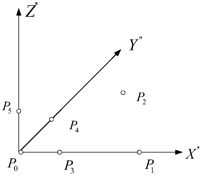
[0028] Such as figure 1 As shown, a single-satellite autonomous orbit determination method using on-satellite push-broom remote sensing image information includes the following steps:

[0029] S1. Preprocessing the push-broom remote sensing image information to obtain several marker points for autonomous orbit determination in the push-broom remote-sensing image. In the embodiment of the present invention, the number of marker points is 6.

[0030] By performing atmospheric correction, image denoising, image terrain relief effect removal, image earth curvature effect removal, push-broom image on-orbit splicing and image high-precision landmark feature robust modeling on the original remote sensing image data, the formation can provide preset accuracy and quality image information, and according to the marker poi...


PUM


Abstract

The invention discloses a single satellite autonomous orbit measuring method adopting on-satellite push-broom remote sensing image information. The method includes the following steps that S1, the push-broom remote sensing image information is preprocessed, and multiple mark points, used for autonomous orbit measuring, in a push-broom remote sensing image are obtained; S2, an orbit measuring system model based on the multiple mark points of the remote sensing image is established according to the mark points, used for autonomous orbit measuring, in the push-broom remote sensing image; S3, a preset solving algorithm is adopted for solving orbit information of the orbit measuring system model, after multiple pieces of position information of a satellite on an orbit are obtained, satellite orbit parameters are fit through multipoint orbit position information, and single satellite autonomous orbit measuring is completed. The satellite orbit information is reversed through ground high-precision mark point information, and the autonomy and reliability of remote sensing satellite orbit measuring are remarkably improved.

Description

technical field [0001] The invention belongs to the field of satellite orbit determination research, and in particular relates to a remote sensing satellite independent orbit determination technology, in particular to a single satellite independent orbit determination method using push-sweep remote sensing image information on the satellite. Background technique [0002] Precise orbit determination of satellites is the basis for satellites to perform established tasks. With the development of aerospace technology, the means of orbit determination are constantly improving, which can be generally divided into: ground-based orbit determination, space-based orbit determination, and astronomical orbit determination. It is not difficult to see that orbit determination technology is developing from non-autonomous to autonomous orbit determination. [0003] Most remote sensing satellites in the world are in the low earth orbit of 400Km ~ 800Km. In the existing methods, the ground m...

Claims


Application Information

Patent Timeline
Patent Type & Authority Patents(China)
IPC IPC(8): G01C21/24
CPCG01C21/24
Inventor 孙俊彭杨陈文谭龙玉
Owner SHANGHAI AEROSPACE CONTROL TECH INST
Why Eureka
Try Eureka