Pseudo-satellite indoor navigation method based on virtual grid

A virtual grid and indoor navigation technology, applied in the field of indoor navigation, can solve the problems of low positioning accuracy and high hardware cost, and achieve the effects of high positioning accuracy, low hardware cost and wide practical value.

Active Publication Date: 2017-03-22
格星微电子科技成都有限公司
View PDF5 Cites 8 Cited by
  • Summary
  • Abstract
  • Description
  • Claims
  • Application Information

AI Technical Summary

Problems solved by technology

[0003] UWB technology is ultra-wideband technology, which uses ultra-wideband radio waves to propagate signals, while Wi-fi technology obtains target location information based on wireless signal strength. The classic pseudolite system defines a...

Method used


Image

  • Pseudo-satellite indoor navigation method based on virtual grid
  • Pseudo-satellite indoor navigation method based on virtual grid
  • Pseudo-satellite indoor navigation method based on virtual grid

Examples


Embodiment Construction

[0091] The following will clearly and completely describe the technical solutions in the embodiments of the present invention with reference to the drawings in the embodiments of the present invention. Obviously, the described embodiment is only one embodiment of the present invention, not all embodiments. Based on the embodiments of the present invention, all other embodiments obtained by persons of ordinary skill in the art without making creative efforts belong to the protection scope of the present invention.

[0092] For the sake of simplicity, common technical knowledge known to those skilled in the art is omitted in the following content.

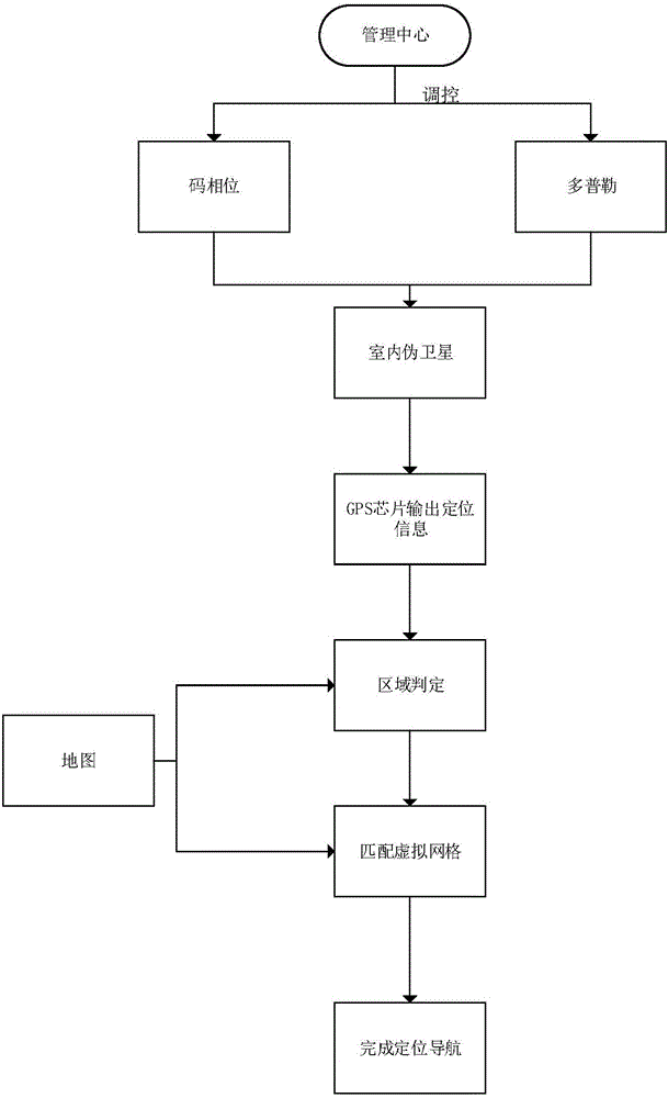
[0093] Such as figure 1 As shown, the pseudolite indoor navigation method based on virtual grid includes:

[0094] S1. Regulating indoor pseudolites, adjusting the PRN numbers of visible GPS satellites to pseudolites; in specific implementation, according to the GPS satellite Kepler parameters stored in the local GPS satellite alman...


PUM


Abstract

The invention discloses a pseudo-satellite indoor navigation method based on a virtual grid. The method comprises the following steps of regulating and controlling an indoor pseudo satellite and adjusting a PRN of a visible GPS satellite to the pseudo satellite; configuring the regulated and controlled pseudo satellite, and generating and sending a pseudo-satellite signal, wherein a reference position of a GPS receiver, which is simulated by each pseudo satellite, is set to be an indoor area center point to be positioned; receiving the pseudo-satellite signal, and analyzing and processing the signal so as to acquire a relative coordinate of a mapping point of the GPS receiver and establish a virtual grid mapping table; inputting the relative coordinate of the mapping point into the virtual grid mapping table, and carrying out retrieval judgment so as to acquire a current user coordinate. The pseudo-satellite indoor navigation method based on the virtual grid possesses high universality, which accords with a usage state of a current mobile phone and other terminals, and simultaneously positioning precision is high, a service experience is good and a wide practical value is possessed.

Description

technical field [0001] The invention relates to the field of indoor navigation, in particular to a virtual grid-based pseudolite indoor navigation method. Background technique [0002] The GNSS positioning and navigation system represented by GPS has been widely used and has had a profound impact on people's daily life; with the development of economy and society and the continuous improvement of people's living standards, people's requirements for navigation and positioning have become more and more More and more demanding, a single traditional positioning has gradually been unable to meet people's needs. At present, there is an urgent need for indoor navigation and positioning, especially in the basements of large commercial buildings, convention centers and other densely populated areas. It is necessary to provide navigation and positioning services for users in indoor confined spaces, and the service requirements are similar to those of outdoors; up to now, indoor positi...

Claims


Application Information

Patent Timeline
IPC IPC(8): G01S19/11
CPCG01S19/11
Inventor 吕飞仁雷乔李占营林静然肖文平
Owner 格星微电子科技成都有限公司
Why Eureka
Try Eureka