Map merging method of unmanned aerial vehicle visual SLAM under city complex environment

A complex environment, multi-UAV technology, applied in the field of visual navigation systems, can solve the problems of occupying UAV memory, increasing the SLAM visual odometer of a single UAV, etc., to achieve compact map form, low endurance, and low endurance. The effect of reducing task execution time

Inactive Publication Date: 2017-04-26
NANJING UNIV OF AERONAUTICS & ASTRONAUTICS
View PDF3 Cites 99 Cited by
  • Summary
  • Abstract
  • Description
  • Claims
  • Application Information

AI Technical Summary

Problems solved by technology

Drawing large-scale environmental maps by a single drone may take up a lot of drone memory
At the same time

Method used


Image

  • Map merging method of unmanned aerial vehicle visual SLAM under city complex environment
  • Map merging method of unmanned aerial vehicle visual SLAM under city complex environment
  • Map merging method of unmanned aerial vehicle visual SLAM under city complex environment

Examples


Embodiment Construction

[0058] Below in conjunction with accompanying drawing, technical scheme of the present invention is described in further detail:

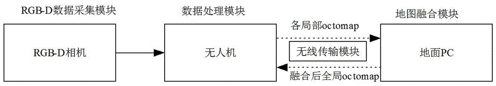
[0059] This design invented a map fusion method for multi-UAV visual SLAM in a complex urban environment, including the following steps:

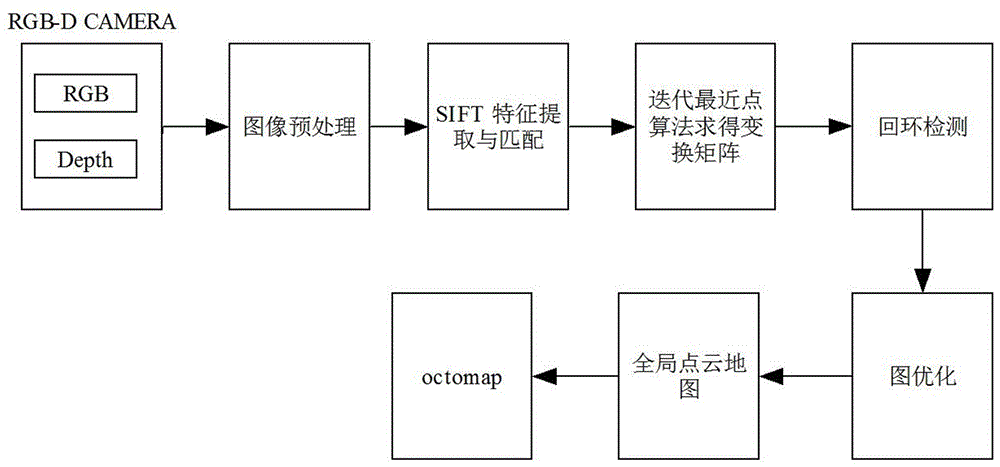
[0060] like figure 1 As shown, the RGB-D camera ZED installed in the drone is used to collect the video stream of the environment, and the RGB image and depth map of each frame of the environment are obtained; The RGB image is preprocessed, and Gaussian filtering is used to filter out noise.

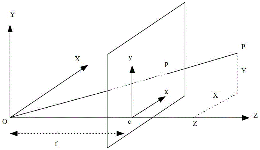
[0061] The RGB-D image is converted into a point cloud; the RGB-D camera uses a pinhole camera model, and the perspective projection relationship is as follows figure 2 shown. The correspondence between the spatial point [x, y, z] and its pixel coordinates [u, v, d] in the image is:

[0062]

[0063] where f x ,f y Respectively represent the focal length of the camera on the x and y axes, c x ,c y Refers to the...


PUM


Abstract

The invention discloses a map merging method of unmanned aerial vehicle visual SLAM under city complex environment. The method comprises the steps of 1, collecting an image through an RGB-D camera installed on each unmanned aerial vehicle, utilizing the unmanned aerial vehicle to conduct pretreatment on the image, and then conducting image registration; 2, constructing a visual odometer, and achieving loop detection; 3, optimizing the posture of the unmanned aerial vehicle; 4, constructing an octomap map, and achieving real-time on-line SLAM; 5, transmitting the octomap into a ground computer, merging a local octomap into a global octomap, and then transmitting the merged all-region octomap to the unmanned aerial vehicle. According to the map merging method of the unmanned aerial vehicle visual SLAM under the city complex environment, calculated quantity is reduced, real-time on-line SLAM can be achieved, and hidden danger of information losses brought by unstable wireless transmission is reduced; meanwhile, the task execution time is shortened, the task execution efficiency is improved, hidden danger brought by insufficient unmanned aerial vehicle cruising ability, finally more precise positioning can be obtained, and a more precise map can be established.

Description

technical field [0001] The invention belongs to the field of visual navigation systems, and specifically relates to a map fusion method for multi-UAV visual SLAM in a complex urban environment. Background technique [0002] Due to the advantages of miniaturization, easy manipulation and control, UAVs are widely used in urban disaster relief, geographic survey and other scenarios. Based on the complexity of the urban environment, the GPS signal is easy to lose, and the cumulative error of the inertial measurement element makes it impossible for the UAV to obtain accurate self-position information, so the UAV cannot achieve autonomous navigation. SLAM technology is a key technology to solve navigation in unknown environments. SLAM technology has been widely used in ground robots and indoor robots. Sensors based on SLAM technology include laser scanners, monocular cameras, stereo cameras, and RGB-D cameras. In recent years, the use of lightweight, cheap, and information-rich ...

Claims


Application Information

Patent Timeline
IPC IPC(8): G01C21/20
CPCG01C21/20G05D1/101
Inventor 钟家跃王从庆贾峰谢勇吴林峰
Owner NANJING UNIV OF AERONAUTICS & ASTRONAUTICS
Why Eureka
Try Eureka