Coastal city time sequence land utilization information extracting method

A time series and information extraction technology, applied in image data processing, instrument, character and pattern recognition, etc., can solve the problems of non-unique segmentation threshold, doping, and difficulty in effectively distinguishing ground object categories.

Active Publication Date: 2017-05-10
XIAMEN UNIV OF TECH
View PDF5 Cites 53 Cited by
  • Summary
  • Abstract
  • Description
  • Claims
  • Application Information

AI Technical Summary

Problems solved by technology

However, threshold segmentation is still unavoidable when the classification feature index extracts feature information, and the same target feature is affected by seasons, regions, etc., and its segmentation threshold may not be unique, and the extracted target feature information is often mixed with Miscellaneous other surface feature information noise
In the land use classification of coastal cities, the spectral characteristics of vegetation shadows and water bodies, tidal wetlands and bare land, and construction land and tidal wetlands are close to each other. Therefore, it is difficult to effectively distinguish the types of land features directly using a single classification feature index

Method used


Image

  • Coastal city time sequence land utilization information extracting method
  • Coastal city time sequence land utilization information extracting method
  • Coastal city time sequence land utilization information extracting method

Examples


Embodiment Construction

[0063] The technical solutions of the present invention will be described in detail below in conjunction with the accompanying drawings.

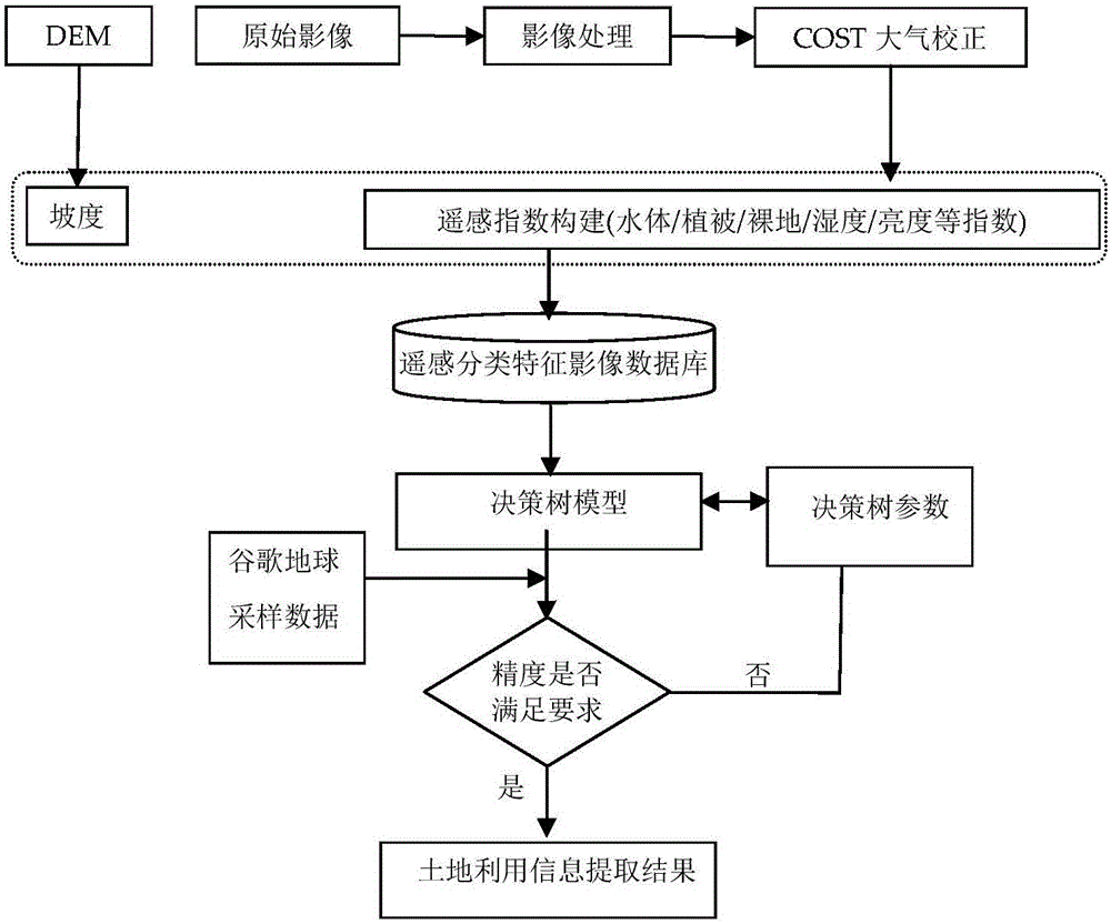
[0064] Such as figure 1 As shown, the present invention provides a method for extracting coastal city time series land use information, comprising the following steps:

[0065] Step 1, data collection and preprocessing, the collected data includes remote sensing images (such as Landsat TM / ETM+ / OLI, Landsat 5 TM / Landsat8 OLI) and digital elevation image DEM data, the content of preprocessing includes mid-resolution remote sensing image Landsat Atmospheric correction is performed based on the COST model, and the gray value of the original pixel is converted into the reflection value of the surface pixel, which specifically includes the following steps:

[0066] (1) Calibrate the remote sensor according to the gain and offset of the remote sensor;

[0067] (2) Convert the spectral radiation value of the remote sensor into the relative reflec...


PUM


Abstract

The invention discloses a coastal city time sequence land utilization information extracting method. The method comprises the following steps: acquiring a remote-sensing image Landsat, and preforming atmospheric correction on the same; constructing a remote-sensing classification feature index database by selecting a group of remote-sensing classification features; acquiring data elevation image DEM data to obtain elevation data and slope data; constructing a decision rule of single-classification feature index or multiple classification feature indexes according to different land utilization types of the coastal city based on a multi-feature decision tree model, classifying the coastal city land utilization step by step according to the rule, and finally determining various branches of the decision tree, detecting the time sequence remote-sensing image change, and distinguishing a mistaken classification land type and a missed classification land type, wherein the method further comprises the content of two parts: evaluating classification precision, and outputting the land utilizationclassification map extracted based on the decision tree model. By use of the extracting method disclosed by the invention, the coastal city land utilizationclassification precision can be greatly improved, and a key problem in the coastal city land utilizationclassification is solved.

Description

technical field [0001] The invention belongs to the technical field of image intelligent processing, and relates to a remote sensing image information extraction method, in particular to a coastal city time series land use information extraction method. Background technique [0002] With the rapid development of the economy, the urban population continues to expand, and the scale of the city continues to expand, and the urban environment and land cover have also undergone tremendous changes. Real-time monitoring of urban development and mastery of urban land use information are the basic requirements for scientific and rational urban planning and environmental management. At present, about 60% of the world's population and 1 / 3 of the large cities with a population of over one million are located in coastal areas. my country has a long and narrow coastline of 18,000km from north to south. In the coastal zone including Bohai Economic Zone, Yangtze River Delta Economic Zone an...

Claims


Application Information

Patent Timeline
Patent Type & Authority Applications(China)
IPC IPC(8): G06K9/00G06K9/62G06T7/254G06T7/246
CPCG06T2207/10032G06T2207/30181G06V20/176G06F18/24323
Inventor 花利忠章欣欣陈曦邓富亮栾海军
Owner XIAMEN UNIV OF TECH
Why Eureka
Try Eureka