Different-scale regional flood damage risk evaluation method
A risk assessment and flood technology, applied in the fields of instrumentation, climate change adaptation, data processing, etc., can solve problems such as more research on the history of flood disasters, less integrated research on multiple research methods, and less research on rainstorm disaster processes.
- Summary
- Abstract
- Description
- Claims
- Application Information
AI Technical Summary
Problems solved by technology
Method used
Image
Examples
Embodiment Construction
[0059] The specific implementation manners of the present invention will be described in detail below in conjunction with the accompanying drawings. It should be understood that the specific embodiments described here are only used to illustrate the present invention, and are not intended to limit the present invention.
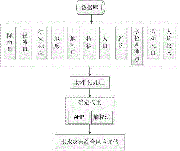
[0060] Figure 1 It is a flow chart of flood disaster risk assessment provided by the present invention, as shown in the figure:
[0061] Step S1, the data collection and organization unit includes rainfall data, runoff, flood disaster frequency, hydrological data, terrain data, land use data, vegetation data, socio-economic data, population density data, hydrological water level observation station density data, local financial Income data and labor force population share data. and compressing the initial data and storing it in the created spatial database;
[0062] Sub-step S1.1, in the precipitation data, the intensity, duration and scope of the rainfal...
PUM
 Abstract
Description
Claims
Application Information
 - R&D
- Intellectual Property
- Life Sciences
- Materials
- Tech Scout
- Unparalleled Data Quality
- Higher Quality Content
- 60% Fewer Hallucinations
Browse by: Latest US Patents, China's latest patents, Technical Efficacy Thesaurus, Application Domain, Technology Topic, Popular Technical Reports.
© 2025 PatSnap. All rights reserved.Legal|Privacy policy|Modern Slavery Act Transparency Statement|Sitemap|About US| Contact US: help@patsnap.com


