Multi-directional polarized light-based real-time navigation device

A navigation device and polarized light technology, applied in the field of positioning technology and multi-information fusion, can solve problems such as little research, and achieve the effects of strong anti-interference ability, high precision, and simple system structure

Active Publication Date: 2017-05-17
DALIAN UNIV OF TECH
View PDF4 Cites 23 Cited by
  • Summary
  • Abstract
  • Description
  • Claims
  • Application Information

AI Technical Summary

Problems solved by technology

However, the previous studies all used the sky polarized light distribution mode to realize navigation and orientation, and there are few studies on how to use polarization information to realize navigation and positioning

Method used


Image

  • Multi-directional polarized light-based real-time navigation device
  • Multi-directional polarized light-based real-time navigation device
  • Multi-directional polarized light-based real-time navigation device

Examples


Embodiment 1

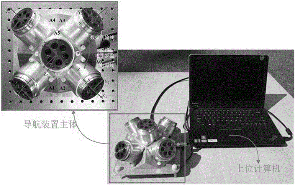
[0052] The specific implementation results of embodiment 1 are as follows, the outdoor experimental test of the navigation device:

[0053] According to the multi-directional polarized light information fusion algorithm, first analyze and compare the polarization azimuth angle θ measured by five polarized light sensors i and degree of polarization d i It is found that the signal of sensor No. 5 is lost, as attached Figure 5 (a) shows the degree of polarization d of the remaining four sensors i The size of , we can see from the figure: d 1 3 2 4 . According to the optimal scheme, No. 2 and No. 4 sensors are selected to calculate the solar space position, as attached Figure 5 (b) represents the experimental comparison diagram of the solar spatial position calculated from the polarization direction vectors measured by No. 2 and No. 4 and No. 1 and No. 3 polarization angle sensors respectively. It can be seen from the figure that the solar space vector obtained by calculati...


PUM


Abstract

The invention discloses a multi-directional polarized light-based real-time navigation device. The multi-directional polarized light-based real-time navigation device comprises a navigation device main body and an upper computer of a multi-directional polarized light information fusion module, wherein the navigation device main body has a polyhedral array structure; a polarized light sensor for measuring the polarization direction of incident light and a light intensity sensor for measuring the intensity of incident sunlight are arranged on each plane of the array structure; one surface of the polyhedral array structure is set to be a horizontal datum plane; an electronic compass for acquiring horizontal datum plane three-dimensional information at least comprising a pitch angle alpha, a roll angle beta and a course angle alpha magnetic north is arranged on the horizontal datum plane; the alpha magnetic north expresses an included angle between the body axis of the electronic compass and a geomagnetic north pole; the multi-directional polarized light information fusion module, an astronomical almanac query module and a geomagnetic information query module are arranged in the upper computer.

Description

technical field [0001] The invention in this paper relates to positioning technology and multi-information fusion technology, especially to the technology of solving sun position information based on multi-directional polarized light sensors, further realizing navigation positioning and orientation, and building a navigation device. Involving patent classification G01 Surveying; testing G01C Measuring distance, level or bearing; surveying; navigation; gyroscope; photogrammetry or videogrammetry G01C21 / 00 Navigation; Navigational Instruments G01C21 / 02 Methods of Applied Astronomy. Background technique [0002] The current positioning technology mainly includes satellite navigation, inertial navigation, astronomical navigation and radio navigation. Satellite and radio navigation are susceptible to interference due to man-made signals. Inertial navigation errors accumulate over time, making precise positioning difficult. The device cost of celestial navigation is high, and t...

Claims


Application Information

Patent Timeline
Patent Type & Authority Applications(China)
IPC IPC(8): G01C21/00G01C21/02G01C21/06G01C21/08
Inventor 褚金奎张慧霞王寅龙张然关乐时超
Owner DALIAN UNIV OF TECH
Why Eureka
Try Eureka