Method for recovering multi-temporal cloud shielding data based on time-phase spectral angle measurement

A technology of spectral angle and recovery method, which is applied in the field of multi-temporal cloud occlusion data recovery, can solve the problem of low recovery accuracy, achieve the effect of improving application depth, application range and application ability, and application range

Active Publication Date: 2017-05-31
黑龙江省工研院资产经营管理有限公司
View PDF6 Cites 4 Cited by
  • Summary
  • Abstract
  • Description
  • Claims
  • Application Information

AI Technical Summary

Problems solved by technology

[0004] The purpose of the present invention is to solve the problem of low recovery accuracy of existing cloud occlusio...

Method used


Image

  • Method for recovering multi-temporal cloud shielding data based on time-phase spectral angle measurement
  • Method for recovering multi-temporal cloud shielding data based on time-phase spectral angle measurement
  • Method for recovering multi-temporal cloud shielding data based on time-phase spectral angle measurement

Examples


specific Embodiment approach 1

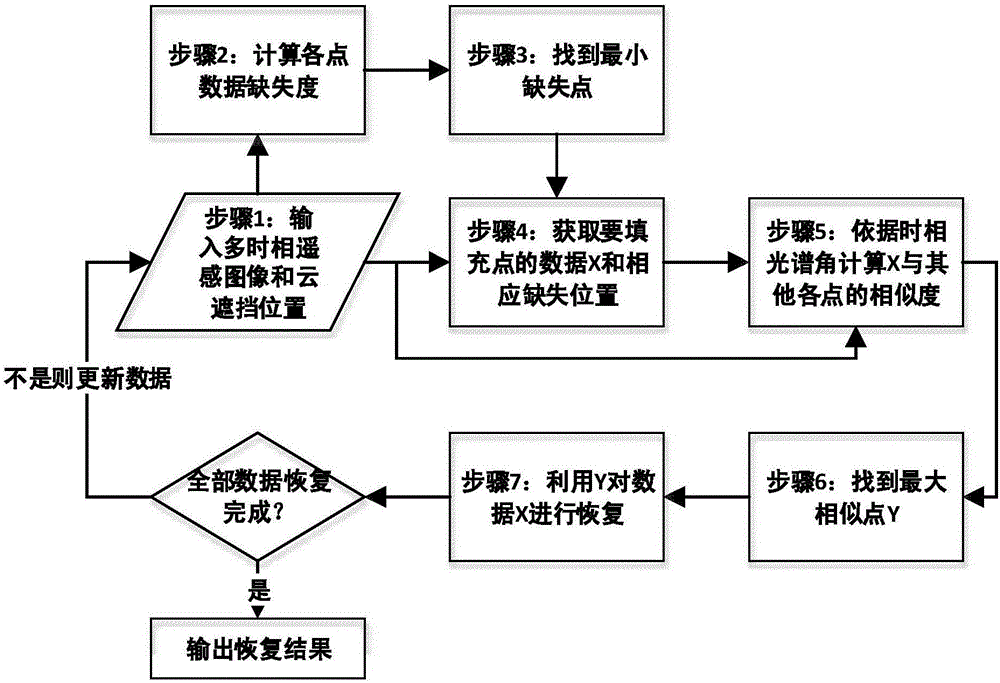
[0024] Specific implementation mode one: combine figure 1 To illustrate this embodiment, the specific process of a multi-temporal cloud occlusion data recovery method based on time-phase spectrum angle in this embodiment is as follows:

[0025] Step 1. Input the multi-temporal multi-spectral remote sensing image with cloud occlusion;

[0026] Step 2, calculating the cloud occlusion data loss degree of each point on the geographical coordinates of the multi-temporal multi-spectral remote sensing image with cloud occlusion;

[0027] Step 3. Taking the point with the smallest cloud occlusion data missing degree at each point on the multi-temporal multi-spectral remote sensing image space with cloud occlusion as the point to be filled;

[0028] Step 4, extracting the multitemporal multispectral data X and the corresponding missing temporal geographic coordinates of the points to be filled;

[0029] Step 5, using the time-phase spectral angle function to calculate the similarity...

specific Embodiment approach 2

[0033] Specific embodiment two: the difference between this embodiment and specific embodiment one is: in the step one, input the multi-temporal multi-spectral remote sensing image with cloud occlusion; specifically:

[0034] Any point in the input space of multi-temporal multi-spectral remote sensing image data with cloud occlusion is a matrix, and its behavior phase is listed as spectrum.

[0035] Other steps and parameters are the same as those in Embodiment 1.

specific Embodiment approach 3

[0036] Specific embodiment three: the difference between this embodiment and specific embodiment one or two is: the cloud occlusion data loss degree of each point on the multi-temporal multi-spectral remote sensing image space with cloud occlusion is calculated in the said step 2; the specific process is:

[0037] The formula for calculating the cloud occlusion data missing degree of point a on the multi-temporal multi-spectral remote sensing image space is as follows:

[0038]

[0039] Other steps and parameters are the same as those in Embodiment 1 or Embodiment 2.


PUM


Abstract

The invention relates to a method for recovering multi-temporal cloud shielding data based on time-phase spectral angle measurement, and aims to solve a problem of low recovery accuracy of an existing cloud shielding data recovery method. The specific process comprises the steps of firstly inputting a multi-temporal multi-spectral remote sensing image having cloud shielding; secondly, calculating the cloud shielding data missing degree of each point on geographic coordinates of the multi-temporal multi-spectral remote sensing image having cloud shielding; thirdly, enabling the point with the minimum missing degree to act as a point required to be filled; fourthly, extracting multi-temporal multi-spectral data X and corresponding missing time-phase geographic coordinates; fifthly, calculating the similarity of the multi-temporal multi-spectral data X and other points except for the point required to be filled by using a time-phase spectral angle function; sixth, finding a point Y with the maximum similarity; seventh, filling the multi-temporal multi-spectral data X of the point required to be filled by using the point Y and a missing data filling algorithm; and eighth, iterating the first step until all cloud shielding data is filled. The method is applied to the field of cloud shielding data recovery.

Description

technical field [0001] The invention relates to a method for recovering multi-temporal cloud occlusion data based on time-phase spectral angles. Background technique [0002] The reliability and integrity of remote sensing images are the basis for realizing social services through remote sensing images. However, due to the inevitable occurrence of cloud occlusion, in many cases, there is a lack of cloud observation data in remote sensing image data, which reduces the reliability of remote sensing images. scope of analysis. Realizing the recovery of cloud occlusion data in remote sensing images can effectively expand the application scope of remote sensing images and improve the application efficiency of satellite optical images, which is of great significance. [0003] The data restoration of the cloud-occluded area of ​​the current remote sensing image is mainly divided into two categories: one is to use only some non-missing data around the missing data in the current ima...

Claims


Application Information

Patent Timeline
IPC IPC(8): G06T5/00
Inventor 谷延锋高国明
Owner 黑龙江省工研院资产经营管理有限公司
Why Eureka
Try Eureka