Underground comprehensive pipe gallery information management method based on BIM and GIS technologies

A technology for comprehensive pipe gallery and information management, applied in geographic information databases, data processing applications, electrical digital data processing, etc., can solve problems such as data management, business collaboration, design model library establishment, and BIM application fields, and reduce Data integration workload, ensuring data integrity, reducing the effect of data migration

Inactive Publication Date: 2017-07-18
CHINA CONSTR UNDERGROUND SPACE
View PDF1 Cites 44 Cited by
  • Summary
  • Abstract
  • Description
  • Claims
  • Application Information

AI Technical Summary

Problems solved by technology

As a new type of municipal infrastructure that has developed rapidly in recent years, some domestic units have developed a 3D underground integrated pipe gallery information management platform based on GIS technology, but there are still deficiencies in data management, business collaboration, design model library establishment, and BIM application fields. , there is no precedent for the implementation of GIS-based BIM design and management applications

Method used


Image

  • Underground comprehensive pipe gallery information management method based on BIM and GIS technologies
  • Underground comprehensive pipe gallery information management method based on BIM and GIS technologies

Examples


Embodiment Construction

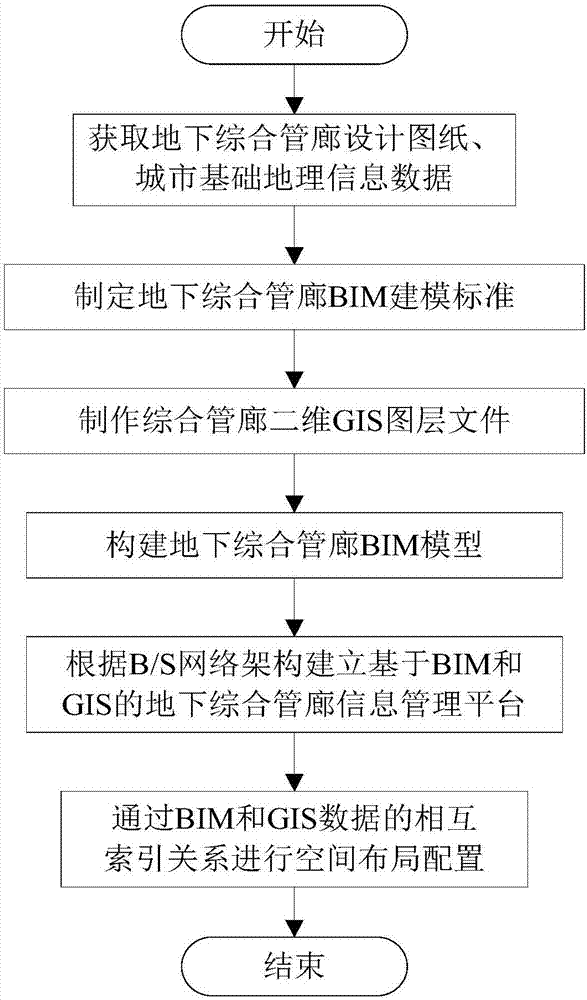
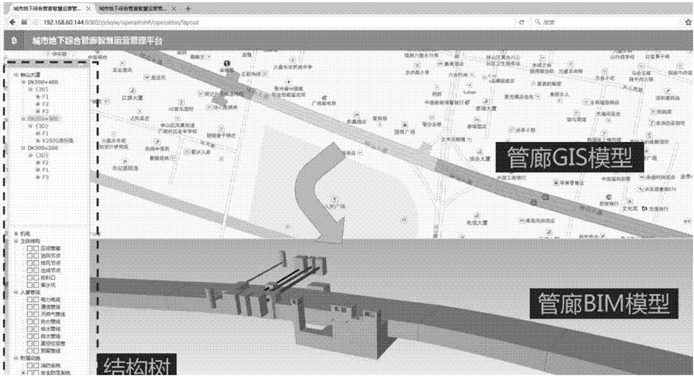
[0026] The present invention adopts the international cutting-edge technology of GIS+BIM information fusion and technology integration, builds a BIM data expression model based on the GIS platform, and deeply integrates the building BIM model and GIS technology to form an integrated information integration platform. The platform architecture With service-oriented design as the concept, digital platform architecture design based on IFC standards and integrated application ideas and technical methods of geospatial information platforms, construction of BIM application network environment for underground comprehensive utility corridors based on B / S network architecture, and integration of spatial geographic information The resources, BIM model and attribute data resources of the underground comprehensive utility corridor realize the display, query, retrieval, positioning and other functions of the underground comprehensive utility corridor, and form a complete set of three-dimensio...


PUM


Abstract

The invention discloses an underground comprehensive pipe gallery information management method based on BIM and GIS technologies. The method comprises the following steps of S1, acquiring an underground comprehensive pipe gallery design drawing and urban basic geographic information data; S2, making an underground comprehensive pipe gallery BIM modeling standard; S3, making a comprehensive pipe-gallery two-dimensional GIS layer file; S4, constructing an underground comprehensive pipe gallery BIM model; S5, according to a B / S network configuration, establishing an underground comprehensive pipe gallery information management platform based on the BIM and the GIS; and S6, through a mutual index relation of BIM and GIS data, carrying out space layout configuration, and simultaneously displaying an underground comprehensive pipe-gallery two-dimensional GIS model and a three-dimensional BIM model. In the invention, a GIS technology and a BIM technology are combined and are applied to comprehensive pipe gallery engineering so that design and operation management persons can carry out multiple-dimension analysis, multi-view space verification and visualization management on underground comprehensive pipe gallery correlation information in a three-dimensional on-site environment. Management efficiency, design quality and operation quality can be increased.

Description

technical field [0001] The invention belongs to the technical field of comprehensive utility corridors, in particular to an information management method for underground comprehensive utility corridors based on BIM and GIS technologies. Background technique [0002] The underground comprehensive pipe gallery, also known as the common ditch, is a municipal public tunnel that implements unified planning, design, construction and maintenance, and is built underground in the city for the centralized laying of various municipal pipelines such as water supply, drainage, gas, electricity, and communications. [0003] Building Information Modeling (BIM) is based on the relevant information data of the construction project as the basis of the model to establish the building model, and use the digital model to design, construct and operate the project. It has the characteristics of visualization, coordination, optimization, simulation and information synthesis. It is triggering an un...

Claims


Application Information

Patent Timeline
Patent Type & Authority Applications(China)
IPC IPC(8): G06Q50/26G06F17/30G06F17/50
CPCG06F16/29G06F30/13G06F30/20G06F2113/14G06Q50/26
Inventor 郑立宁杨超薛国洲田强李鹏王建王明白镭罗春燕许凯高远
Owner CHINA CONSTR UNDERGROUND SPACE
Why Eureka
Try Eureka