Method of improving gravity field inversion precision based on disturbance intersatellite relative velocity

A technology of relative speed and absolute speed, applied in the aerospace field, can solve the problems of not being able to improve the spatial and temporal resolution of satellite observation data at the same time, shortening the flight life of satellites, and losing the accuracy of the long-wave gravity field inversion of the earth.

Active Publication Date: 2017-08-01
CHINA ACADEMY OF SPACE TECHNOLOGY
View PDF6 Cites 11 Cited by
  • Summary
  • Abstract
  • Description
  • Claims
  • Application Information

AI Technical Summary

Problems solved by technology

[0003] Among them, the disadvantage of the single formation satellite gravity plan is that the spatial resolution and time resolution of satellite observation data cannot be improved at the same time
[0006] However, there are also many disadvantages in the double-star formation satellite gravity plan: (1) Since the non-conservative force acting on the satellite body increases by about an order of magnitude as the satellite orbit height decreases by 100km, the unstable satellite working platform will not only affect the load. The measurement accuracy and dynamic range of the satellite will be shortened, and the flight life of the satellite will be shortened, which will affect the inversion accuracy of the Earth's static and time-varying gravity field; The attitude control of the satellite platform will be greatly increased; (3) When the relative distance between the satellites is shortened, although the measurement accuracy of the earth's medium-short-wave gravity field can be appropriately improved, the inversion of the earth's long-wave gravity field will be lost at the same time due to the too close distance between the two stars (4) Since the single-formation satellite gravity measurement plan is still used, the key problem of further improving the spatial resolution of the earth's gravity field cannot be well solved

Method used


Image

  • Method of improving gravity field inversion precision based on disturbance intersatellite relative velocity
  • Method of improving gravity field inversion precision based on disturbance intersatellite relative velocity
  • Method of improving gravity field inversion precision based on disturbance intersatellite relative velocity

Examples


Embodiment Construction

[0072] In order to make the purpose, technical solution and advantages of the present invention clearer, the following will further describe the public implementation manners of the present invention in detail with reference to the accompanying drawings.

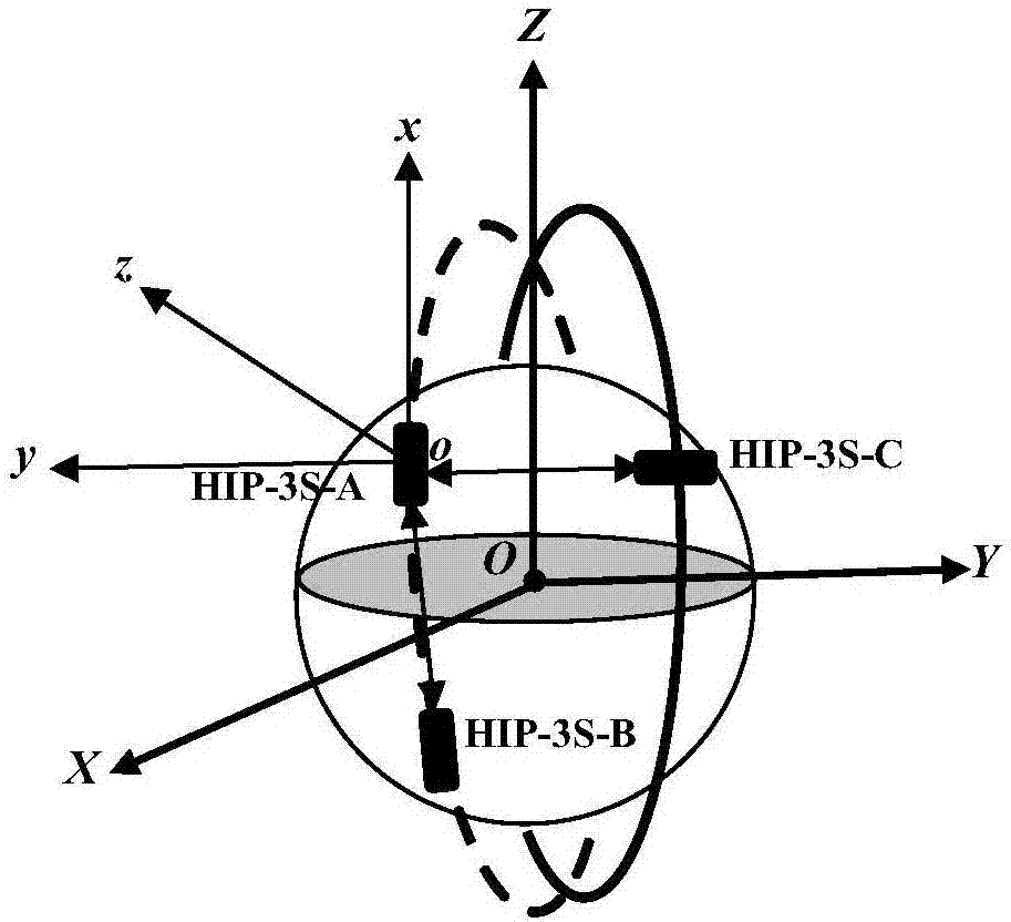
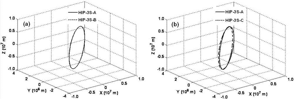
[0073] The method disclosed by the present invention for improving the accuracy of gravity field inversion based on perturbing the inter-satellite relative velocity is suitable for the next generation Samsung formation satellite gravity plan (Hybrid-Inline-Pendulum-Three-Satellite, HIP-3S-A / B / C). in, figure 1 , showing a schematic diagram of a next-generation HIP-3S-A / B / C three-star formation measurement principle in an embodiment of the present invention; figure 2 ,yes figure 1 The schematic diagram of the satellite orbit of the next-generation HIP-3S-A / B / C three-star formation shown in . Among them, HIP-3S-A / B is a serial formation, and HIP-3S-A / C is a pendulum formation.

[0074] Such as figure 1 and 2 The gravity p...


PUM


Abstract

The invention discloses a method of improving gravity field inversion precision based on disturbance intersatellite relative velocity. The method comprises steps that according to a satellite-borne range finer and a satellite-borne GPS receiver, and a disturbance intersatellite relative velocity (img file='DDA001263047990000011. TIF' wi='216' he='78'), a single satellite disturbance absolute velocity, and a disturbance absolute position are determined; according to the single satellite disturbance absolute velocity, a Lagrange interpolation formula is adopted to calculate a double-satellite disturbance absolute acceleration vector difference (img file='DDA0001263047990000012. TIF' wi='190' he='79'); according to the disturbance absolute position, a unit vector is determined; according to the determined unit vector and the double-satellite disturbance absolute acceleration vector difference (img file='DDA0001263047990000013. TIF' wi='202' he='78'), the line of sight (img file='DDA0001263047990000015. TIF' wi='347' he='78') of the determined double-satellite disturbance absolute acceleration vector difference (img file='DDA0001263047990000014 TIF' wi='166' he='79') is determined; according to the line of sight (img file='DDA0001263047990000015. TIF' wi='347' he='78') and the disturbance intersatellite relative velocity, a disturbance intersatellite relative velocity observation equation is determined; according to the disturbance intersatellite relative velocity observation equation, earth gravity field inversion is carried out, and earth gravitation potential coefficient precision and accumulated geoid precision are determined. The method is advantageous in that the inversion of the earth gravity field is carried out accurately and quickly, and the earth gravity field inversion precision and spatial resolution are improved.

Description

technical field [0001] The invention belongs to the field of aerospace technology, and in particular relates to a method for improving the accuracy of gravity field inversion based on disturbing the inter-satellite relative velocity. Background technique [0002] The satellite gravity measurement project is another innovation and breakthrough in the field of geodesy after the successful construction of the US Global Positioning System (GPS) constellation. Potential methods and techniques. At present, the commonly used satellite gravity measurement plan is a single formation satellite gravity plan (such as Gravity Recovery and Climate Experiment, GRACE plan). [0003] Among them, the disadvantage of the single formation satellite gravity plan is that the spatial resolution and time resolution of satellite observation data cannot be improved at the same time. According to Heisenberg’s uncertainty principle, it can be known that the spatial resolution S of satellite observati...

Claims


Application Information

Patent Timeline
Patent Type & Authority Applications(China)
IPC IPC(8): G01V7/00G01V7/06
CPCG01V7/00G01V7/06
Inventor 郑伟李钊伟
Owner CHINA ACADEMY OF SPACE TECHNOLOGY
Why Eureka
Try Eureka