Substation equipment infrared thermal image shooting navigation method and device

A technology of infrared heat map and navigation device, which is applied in navigation, measurement device, surveying and navigation, etc., and can solve problems such as hidden dangers of life safety

Inactive Publication Date: 2017-08-18
杭州图谱电力技术有限公司
View PDF5 Cites 4 Cited by
  • Summary
  • Abstract
  • Description
  • Claims
  • Application Information

AI Technical Summary

Problems solved by technology

Moreover, since there is a safe working distance between the photographer and the substation equipment, it is even more necessary if the navigation method and device can further solve the hidden dangers of life safety during shooting.

Method used


Image

  • Substation equipment infrared thermal image shooting navigation method and device
  • Substation equipment infrared thermal image shooting navigation method and device
  • Substation equipment infrared thermal image shooting navigation method and device

Examples


Embodiment Construction

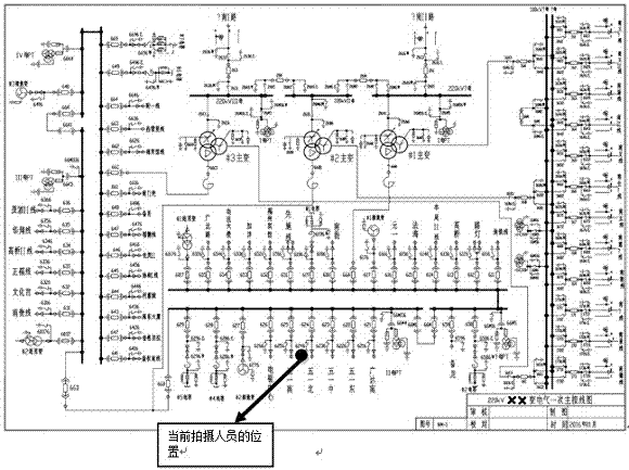
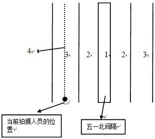
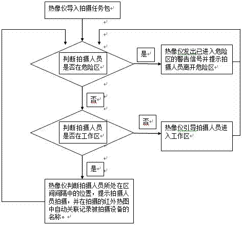
[0031] A navigation method for substation equipment infrared heat map shooting, such as figure 1 , 2 , 3, including the following steps:

[0032] Based on the basic data of substations and substation intervals, the model of substations and substation intervals is established, and displayed on the corresponding position of the electronic map; for example figure 1 , the electronic ground Figure 1 Generally, it is the primary wiring diagram of the substation, which is very familiar to the photographers working in the substation. Moreover, it is very simple to make such a task package. You only need to use professional tools to combine the primary wiring diagram of the substation in autocad format, the GPS coordinates of the four vertices of the substation interval interval, and the type of interval interval. No need to sort, which simplifies the operation people's work. When generated on the thermal imager as figure 1 After the electronic map, in fact, the thermal imager al...


PUM


Abstract

The invention discloses a substation equipment infrared thermal image shooting navigation method and device. The method is characterized is that, to begin with, a shooting task package is input into a thermal imager, wherein the shooting task package at least comprises interval names, interval models and interval coordinate information of a substation to be shot; a region where a shooting person locates is judged according to the position coordinates of the thermal imager; when the shooting person enters a danger zone, the thermal imager gives a warning signal for reminding of entering the danger zone and reminds the shooting person to leave the danger zone; when the shooting person enters a work zone, the thermal imager gives a reminding signal for reminding of entering the work zone, and reminds the shooting person that infrared thermal image shooting can be carried out; and after the shooting person enters the work zone, the thermal imager judges the position of the shooting person in an interval, reminds the shooting person to carry out shooting, and automatically associates and records the names of shot devices in shot infrared thermal images. The navigation method and device is specially developed for substation equipment infrared thermal image shooting, thereby reducing burden of task package producers and shooting persons, improving shooting safety and efficiency, saving cost and facilitating big data archiving and cloud computing of the infrared thermal images.

Description

technical field [0001] The invention relates to the technical field of infrared detection of substation equipment, in particular to a navigation method and device for shooting infrared thermal images of substation equipment. Background technique [0002] The infrared thermal imager detects infrared heat through non-contact, and converts it to generate a thermal image and temperature value corresponding to the thermal distribution field on the surface of the object, and then displays it on the display, and can calculate the temperature value. testing equipment. Infrared thermal imaging cameras are widely used in various equipment maintenance scenarios, such as substations. By taking thermal images of various equipment, the thermal image temperature distribution map of various equipment can be obtained, and the thermal image temperature distribution map can Discover or predict hidden dangers of various equipment, so as to eliminate hidden dangers in advance. [0003] There a...

Claims


Application Information

Patent Timeline
Patent Type & Authority Applications(China)
IPC IPC(8): G01J5/00G01J5/50G01S19/48G01C21/00
CPCG01C21/005G01J5/00G01S19/48G01J2005/0077G01J5/485G01J5/03
Inventor 袁杰
Owner 杭州图谱电力技术有限公司
Why Eureka
Try Eureka