
Near space moving target positioning method based on unmanned aerial vehicle

A technology for unmanned aerial vehicles and moving targets, which is applied in the field of positioning of moving targets in near space based on unmanned aerial vehicles. The effect of good maneuverability and strong detection ability

Inactive Publication Date: 2017-09-01
NANJING UNIV OF AERONAUTICS & ASTRONAUTICS
View PDF6 Cites 29 Cited by
  • Summary
  • Abstract
  • Description
  • Claims
  • Application Information

AI Technical Summary

Problems solved by technology

The traditional single station positioning model needs to know the distance value of the target relative to the UAV, but in the actual combat background, the electromagnetic environment is complex, and the laser range finder often cannot be used normally. At this time, a safer and more effective positioning solution is needed
Considering the infrared characteristics of the moving target in the near space and the detection characteristics of the airborne infrared sensor (only the angle information of the target can be detected), a single infrared detector can only obtain a straight line in space containing the target point, and cannot accurately locate

Method used


Image

  • Near space moving target positioning method based on unmanned aerial vehicle
  • Near space moving target positioning method based on unmanned aerial vehicle
  • Near space moving target positioning method based on unmanned aerial vehicle

Examples


Embodiment Construction

[0024] Below in conjunction with accompanying drawing, technical scheme of the present invention is described in further detail:

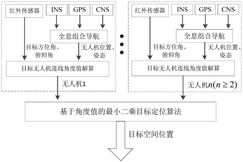
[0025] The present invention is mainly a multi-UAV cooperative target positioning method for near-space vehicles, and the scheme design diagram is shown in the attached figure 1 shown.

[0026] A method for locating a moving target in near space based on an unmanned aerial vehicle, comprising the following steps:

[0027] Step 1), set up two UAVs A and B, and each UAV is equipped with an infrared detector and a holographic integrated navigation system including INS, GPS, and CNS navigation sensors.

[0028] Step 2), use two UAVs A and B to detect the target at the same time, and obtain the angle value of the line connecting the target and the two UAVs A and B in the space Cartesian coordinate system.

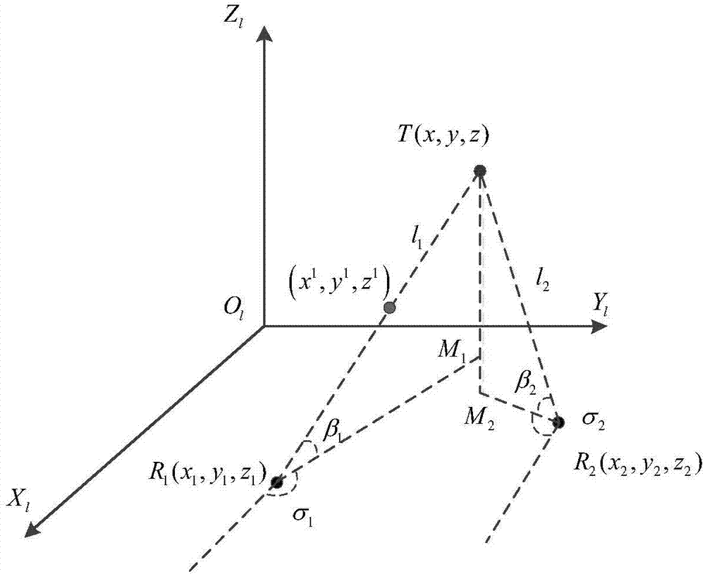
[0029] figure 2 is the target positioning schematic diagram of UAVs A and B simultaneously detecting the moving target T at time k, where O l -...


PUM


Abstract

The invention discloses a near space moving target positioning method based on an unmanned aerial vehicle, which belongs to the technical field of unmanned aerial vehicle target positioning. The method comprises the following steps: firstly, an infrared target detector loaded on the unmanned aerial vehicle is used for acquiring a target angle measurement value, in combination of an unmanned aerial vehicle navigation system, the position and the attitude information of the unmanned aerial vehicle are outputted, and the angle value of the connection line between the target and the unmanned aerial vehicle in an earth-rectangular coordinate system is calculated; then, according to the calculated angle value, the least-squares solution of the target in the earth-rectangular coordinate system is solved; and finally, the solved rectangular coordinates are converted to the longitude, the latitude and the height. The method can realize high-precision positioning of the near space target when a laser range finder or a radar can not be used normally, and can be applied to multi-unmanned aerial vehicle formation cooperative positioning.

Description

technical field [0001] The invention relates to the technical field of unmanned aerial vehicle target positioning, in particular to a method for positioning a moving target in near space based on an unmanned aerial vehicle. Background technique [0002] At present, there are mainly three types of detection systems for hypersonic moving targets in near space: ground-based detection systems, space-based detection systems, and space-based detection systems. few. [0003] The ground-based detection system is easily affected by the curvature of the earth, and there are blind spots. When the target flies in the thin atmosphere of the adjacent space, the surface of the body will rub against the air violently to generate plasma, which will refract and absorb electromagnetic wave signals. The long distance and the stealth design of the fuselage, etc., lead to a small reflection area of ​​the radar, which is difficult to detect. [0004] The target detection of the space-based detec...

Claims


Application Information

Patent Timeline
Patent Type & Authority Applications(China)
IPC IPC(8): G01S5/16G01S19/49G01C21/16
CPCG01S5/16G01C21/165G01S19/49
Inventor 唐攀飞熊智许建新杨菁华邢丽王正淳孔雪博施丽娟戴怡洁殷德全万众黄欣闵艳玲鲍雪李一博罗玮张苗
Owner NANJING UNIV OF AERONAUTICS & ASTRONAUTICS
Learn More