
A UAV-based automatic multi-angle surface spectrum measurement system and method

An automatic measurement and unmanned aerial vehicle technology, applied in control/regulation systems, non-electric variable control, vehicle position/route/height control, etc., can solve the problems of long measurement time and high labor intensity, and achieve improved measurement efficiency, The effect of improving calibration accuracy and spectral measurement efficiency

Active Publication Date: 2020-04-14
CHINA CENT FOR RESOURCES SATELLITE DATA & APPL
View PDF9 Cites 0 Cited by
  • Summary
  • Abstract
  • Description
  • Claims
  • Application Information

AI Technical Summary

Problems solved by technology

[0002] For a long time, when performing satellite-to-ground synchronous calibration of satellite sensors in the field, the spectral measurement of ground objects in the calibration field is carried out manually by carrying the spectral measurement instrument on the running field. This method not only takes a long time to measure, but also is labor-intensive.

Method used


Image

  • A UAV-based automatic multi-angle surface spectrum measurement system and method
  • A UAV-based automatic multi-angle surface spectrum measurement system and method
  • A UAV-based automatic multi-angle surface spectrum measurement system and method

Examples


Embodiment Construction

[0034] Specific embodiments of the present invention will be further described in detail below in conjunction with the accompanying drawings.

[0035] In order to improve the efficiency and measurement accuracy of the field spectrum measurement, the present invention carries the spectrum measuring instrument on the rotor UAV to measure the field reflection characteristics, and designs the spectrum measurement platform so that the UAV can maintain measurement in any flying attitude. The fiber goes straight down or at a specific angle to the vertical down. The invention overcomes the disadvantages of low measurement efficiency and poor measurement accuracy in the field of using a manual spectrum measuring instrument in the past, and realizes the efficient measurement of the field spectrum of the field satellite-ground synchronous calibration of the satellite sensor.

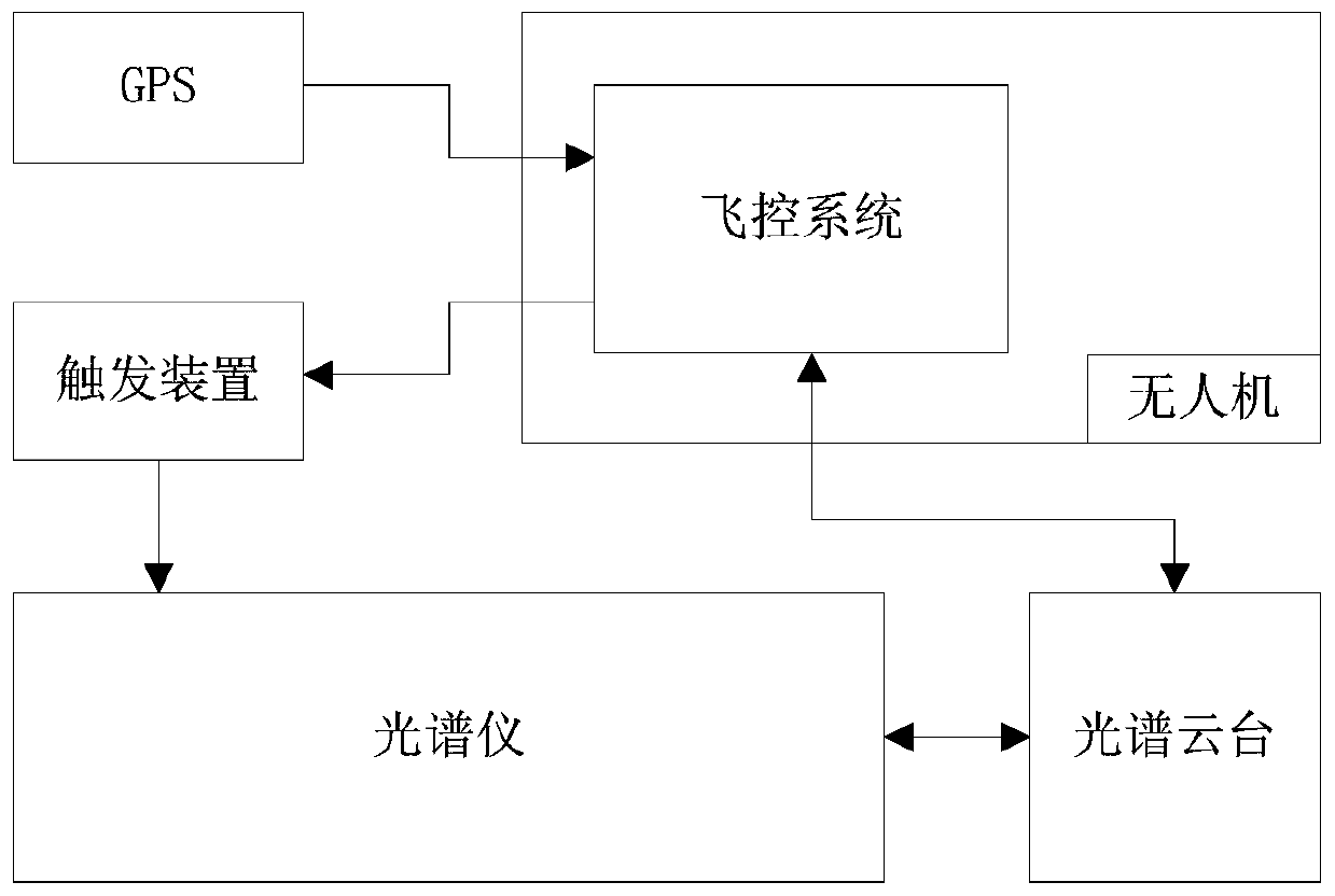
[0036] Such as figure 1 As shown, a kind of multi-angle surface spectrum automatic measurement system based on ...


PUM


Abstract

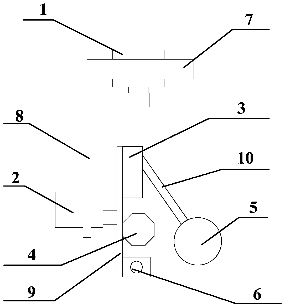
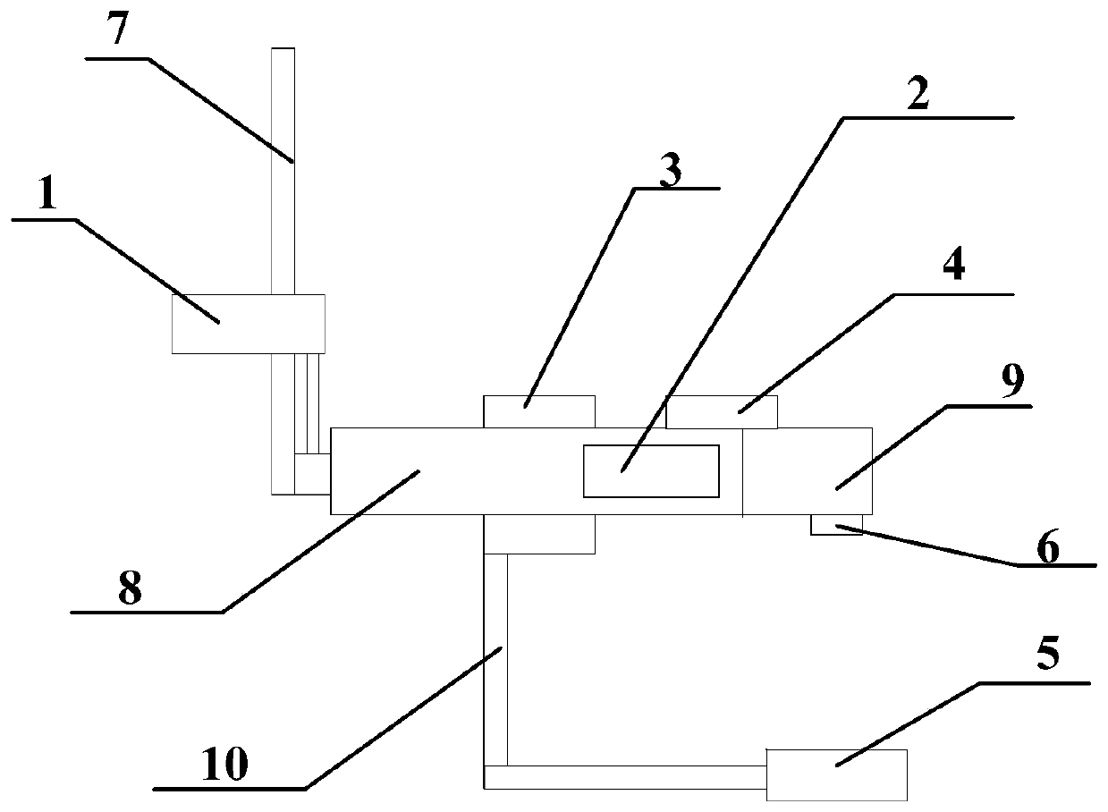
The invention relates to an unmanned aerial vehicle based multi-angle ground surface spectrum automatic measurement system and method. The automatic measurement system comprises an unmanned aerial vehicle, a spectrum cradle head, a spectrometer, a GPS and a trigger device, and is characterized in that the unmanned aerial vehicle further comprises a flight control system; the spectrometer is fixedly installed at the bottom of the unmanned aerial vehicle; the spectrum cradle head is installed at the side surface of the spectrometer and used for ensuring that an optical fiber probe is always vertical downward or keeps a fixed included angle with the vertical direction in the flying process of the unmanned aerial vehicle; the trigger device is installed on a measurement switch of the spectrometer and triggers the measurement switch according to an instruction of the flight control system so as to enable the spectrometer to operate; and the GPS is installed on the unmanned aerial vehicle and used for performing positioning and navigation on the unmanned aerial vehicle. The automatic measurement system can realize automatic and fast measurement for the spectrum of field ground objects in remote sensor field calibration, authenticity inspection and the like, and can also realize multi-angle spectrum measurement for the ground objects at different azimuth angles and different observation zenith angles.

Description

technical field [0001] The invention relates to a multi-angle surface spectrum automatic measurement system and method based on a multi-rotor unmanned aerial vehicle, which is used for automatic and rapid measurement of the field ground feature spectrum for remote sensor site calibration and authenticity inspection. Background technique [0002] For a long time, when performing satellite-to-ground synchronous calibration of satellite sensors in the field, the spectral measurement of ground objects in the calibration field is carried out manually by carrying the spectral measurement instrument on the running field. This method not only takes a long time to measure, but also is labor-intensive. . The transit time of satellites is extremely short, and only when the measurement of the entire site is completed in the shortest possible time can the "satellite-ground synchronization" be truly realized. In order to improve the efficiency of field spectrum measurement, the present i...

Claims


Application Information

Patent Timeline
Patent Type & Authority Patents(China)
IPC IPC(8): G05D1/08G05D1/10
CPCG05D1/0808G05D1/101
Inventor 潘志强张浩平韩启金刘李张学文赵航
Owner CHINA CENT FOR RESOURCES SATELLITE DATA & APPL
Learn More