In-orbit real-time imaging navigation and registration method for stationary satellites

A geostationary satellite, real-time imaging technology, used in integrated navigators, navigation calculation tools, etc., to achieve the effect of being suitable for engineering applications, reducing difficulty and design costs

Inactive Publication Date: 2017-09-26
SHANGHAI SATELLITE ENG INST
View PDF4 Cites 25 Cited by
  • Summary
  • Abstract
  • Description
  • Claims
  • Application Information

AI Technical Summary

Problems solved by technology

[0004] The research data on image navigation and registration in the United States shows that in the engineering application of geostationary meteorological satellites, the main influencing factors of instrument line-of-sight pointing are analyzed but not classified according to different types of error

Method used


Image

  • In-orbit real-time imaging navigation and registration method for stationary satellites
  • In-orbit real-time imaging navigation and registration method for stationary satellites
  • In-orbit real-time imaging navigation and registration method for stationary satellites

Examples


Embodiment Construction

[0022] The present invention will be described in detail below in conjunction with specific embodiments. The following examples will help those skilled in the art to further understand the present invention, but do not limit the present invention in any form. It should be noted that those skilled in the art can make several modifications and improvements without departing from the concept of the present invention. These all belong to the protection scope of the present invention.

[0023] The geostationary satellite on-orbit real-time imaging navigation and registration method of the present invention comprises the following steps:

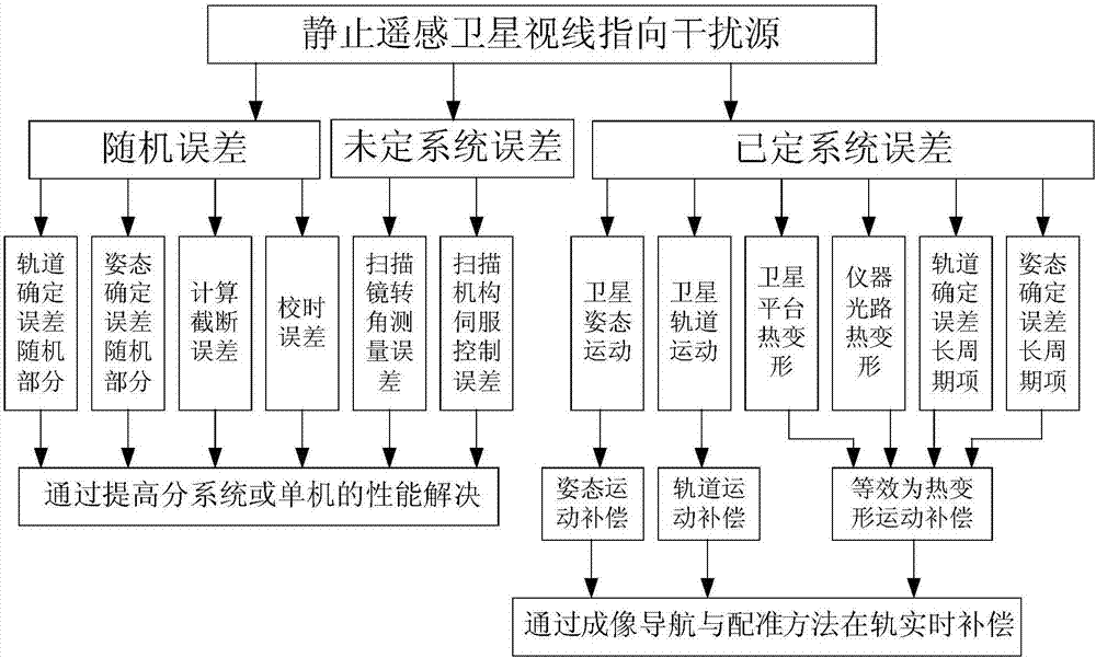
[0024] Step 1: Analyze the error sources that affect the line-of-sight accuracy of remote sensing satellites, and divide the error sources into random errors and systematic errors. For random errors and undetermined system errors, the interference to the pointing accuracy of the instrument can be reduced by improving the performance indicators o...


PUM


Abstract

The invention provides an in-orbit real-time imaging navigation and registration method for stationary satellites. The in-orbit real-time imaging navigation and registration method includes steps of firstly, analyzing error sources with influence on the sight line pointing precision of the remote sensing satellites and dividing the error sources into random errors and system errors; secondly, dividing given system error sources into attitude deviation, orbit excursion and thermal deformation; thirdly, arranging imaging navigation and registration special computation units on the satellites; fourthly, adding computation results of three compensation modules by the aid of each onboard imaging navigation and registration unit and utilizing the sums of the computation results as total compensation quantities. The in-orbit real-time imaging navigation and registration method has the advantages that scanning paths, on earth surfaces, of instrument sight lines can be navigated to reach expected locations by means of compensation under the conditions of interference and influence of space environments on the remote sensing satellites, accordingly, images downloaded from the satellites can be matched with earth nominal grid images generated under nominal ideal conditions, and errors can be within index ranges under the control.

Description

technical field [0001] The invention relates to an imaging navigation and registration method, in particular to a geostationary satellite on-orbit real-time imaging navigation and registration method. Background technique [0002] In numerical weather prediction, it is necessary to locate regional complex weather, track the development trend of severe weather and generate cloud image animation. This requires that the absolute geographic location corresponding to the image is accurately positioned, and the relative positional relationship registration of adjacent images is accurate. The accuracy of imaging and navigation registration is related to the processing accuracy of quantitative remote sensing products such as weather diagnosis, cloud image analysis, and disaster monitoring applications. However, satellite platforms and remote sensing instruments are affected by factors such as space mechanical environment and thermal environment changes. Satellites will have orbital...

Claims


Application Information

Patent Timeline
IPC IPC(8): G01C21/24G01C21/20
CPCG01C21/20G01C21/24
Inventor 董瑶海吕旺张海陈文强沈毅力
Owner SHANGHAI SATELLITE ENG INST
Why Eureka
Try Eureka