Bus based urban GNSS frangibility monitoring system and method

A monitoring system and bus technology, applied in radio wave measurement system, satellite radio beacon positioning system, measurement device, etc., can solve the problems of inability to monitor GNSS vulnerabilities in cities, limited number of sampling samples, and insufficient real-time performance

Active Publication Date: 2017-10-13
SHANGHAI JIAO TONG UNIV
View PDF6 Cites 13 Cited by
  • Summary
  • Abstract
  • Description
  • Claims
  • Application Information

AI Technical Summary

Problems solved by technology

Currently, the monitoring of urban GNSS navigation is mainly based on the establishment of a small number of fixed monitoring stations, and relevant scientific research also uses special experimental vehicles to sample and analyze GNSS navigation data on a small number of specific streets in the city, which have small coverage and limited number of samples. , Insufficient real-time performance and other shortcomings, it is impossible to conduct real-time and comprehensive monitoring of urban GNSS vulnerabilities

Method used


Image

  • Bus based urban GNSS frangibility monitoring system and method
  • Bus based urban GNSS frangibility monitoring system and method
  • Bus based urban GNSS frangibility monitoring system and method

Examples


Embodiment Construction

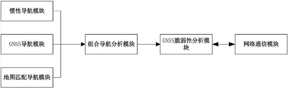
[0026] Such as figure 1 As shown, the urban GNSS vulnerability monitoring system based on buses in the present embodiment includes: inertial navigation module, GNSS navigation module, map matching navigation module, integrated navigation analysis module, GNSS vulnerability analysis module and network communication module, wherein : The GNSS navigation coordinates of the bus position measured by the GNSS navigation module [L g ,λ g , h g ] and coordinate system OX E Y N Z U Medium GNSS navigation speed and pseudoranges Pseudorange rate The inertial navigation module collects the acceleration information and angular velocity information of the bus to obtain the inertial navigation coordinates [Lins ,λ ins , h ins ] and inertial navigation speed After the map matching navigation module collects the driving information, it obtains the map matching navigation coordinates through the map matching algorithm [L odon ,λ odon , h odon ] and map to match navigation speed...


PUM


Abstract

The invention relates to a bus based urban GNSS frangibility monitoring system and method. The system comprises an inertial navigation module, a GNSS navigation module, a map matching navigation module, a combined navigation analysis module, a GNSS frangibility analysis module and a network communication module. According to the system and method, public transport tools, namely urban buses, and vehicle-mounted equipment thereof are used, the realization cost is low, collected data is high in instantaneity, large in the sample amount and wide in coverage range, a reliable, accurate and real-time statistical analysis result can be obtained, driving characteristics of the buses are combined fully, characteristic point matching and dead reckoning navigation are carried out via mileometers and e-maps, it can be ensured that the system can carry out navigation effectively event GNSS navigation is in failure or is interfered/cheated, and thus, continuous monitoring is realized, and GNSS frangibility born by the buses can be calculated more accurately.

Description

technical field [0001] The present invention relates to a technology in the field of transportation, in particular to a bus-based urban GNSS vulnerability monitoring system and method thereof. Background technique [0002] The global satellite navigation system (GNSS) can provide global, all-weather, real-time positioning, speed measurement and timing services. In urban areas with high-rise buildings, dense trees, and serious electromagnetic radiation pollution, GNSS signals are easily affected by occlusion, multipath, interference, etc., which greatly increases the vulnerability of urban GNSS navigation. GNSS vulnerability monitoring is to monitor the adverse impact of GNSS system internal and external factors on GNSS service performance, and the results can indicate the degree to which GNSS service performance is adversely affected. In order to improve the performance and reliability of urban GNSS applications, it is necessary to monitor and grasp the vulnerability of urb...

Claims


Application Information

Patent Timeline
Patent Type & Authority Applications(China)
IPC IPC(8): G01S19/23G01C21/18
CPCG01C21/18G01S19/23
Inventor 战兴群刘宝玉刘金玉朱兵
Owner SHANGHAI JIAO TONG UNIV
Why Eureka
Try Eureka