Check patentability & draft patents in minutes with Patsnap Eureka AI!

Satellite navigation, wireless finger and Beidou short message communication based train positioning system

A technology of satellite navigation and train positioning, applied in the direction of automatic system, transportation center control system, railway signal, etc., can solve the problems of increasing system complexity, heavy installation and maintenance workload, and not getting rid of the dependence on trackside communication infrastructure, etc. Achieve the effect of reducing system complexity, reducing maintenance workload, and improving system reliability

Pending Publication Date: 2017-10-20
SIGNAL & COMM RES INST OF CHINA ACAD OF RAILWAY SCI +4
View PDF4 Cites 4 Cited by
  • Summary
  • Abstract
  • Description
  • Claims
  • Application Information

AI Technical Summary

Problems solved by technology

[0007] For the above method 1, a large amount of equipment needs to be installed beside the track, the construction cost is high, the installation and maintenance are difficult, and both the track circuit and the axle counting are inevitably vulnerable to interference.
Especially the track circuit method widely used in China at present, there are problems of red light band and undead
[0008] For the above method 2, on the one hand, the radar is easily disturbed by rain, metal objects, etc., and the tachometer cannot effectively cope with idling and skidding; even if the two are combined, the error caused by the wear of the wheel diameter cannot be avoided, and the wheel diameter data needs to be corrected regularly; On the other hand, a large number of ground balises need to be deployed beside the track, and the installation and maintenance workload is heavy. Once the line changes, the balise needs to be reconfigured, which is troublesome and error-prone; in addition, the balise exposed in the center of the line is also easy to be Covered or smashed by train spills, or stolen
Because the transponder is a one-way communication, when the positioning information is transmitted to the trackside, a large number of ground communication base stations or wireless access points must be deployed, or leaky cables or leaky waveguides need to be deployed along the track, resulting in high system construction costs and easy access. disturbed
[0009] For the above mode 3, by combining mode 1 and mode 2, although the positioning accuracy is improved, the complexity of the system is increased, and more and more complicated equipment and systems are introduced. Moreover, since the track circuit separation area is not a physical point, but a section with a blurred boundary, which has limited improvement in absolute accuracy, and once the orbital parameters change, it is easy to introduce new interference
At the same time, the number of wayside equipment in mode 3 has not decreased, and at the same time, the dependence on the wayside communication infrastructure has not been eliminated

Method used


Image

  • Satellite navigation, wireless finger and Beidou short message communication based train positioning system
  • Satellite navigation, wireless finger and Beidou short message communication based train positioning system

Examples


Embodiment Construction

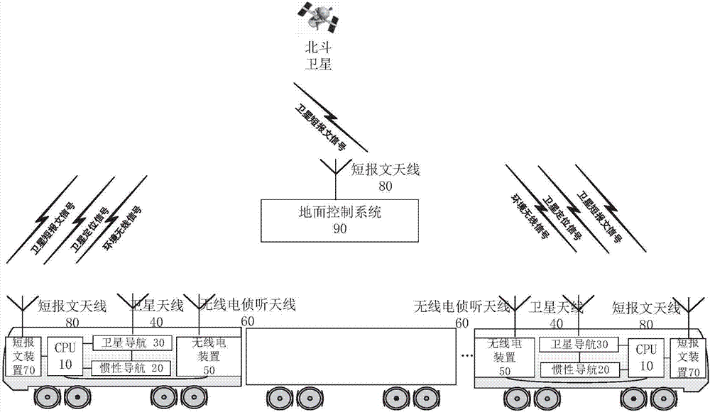
[0041] Attached belowfigure 1 -2 The train positioning system and positioning method based on satellite navigation, wireless fingerprint and satellite short message communication of the present invention are described in detail. The satellites in this embodiment are Beidou satellites as an example.

[0042] Such as figure 1 As shown, the train positioning system based on satellite navigation, wireless fingerprint and Beidou short message communication includes: a train front positioning unit and a train rear positioning unit;

[0043] The train head positioning unit comprises: the first short message device 70, the first CPU 10, the first satellite navigation device 30, the first inertial navigation device 20 and the first radio device 50; the first CPU 10 communicates with the first short message respectively The device 70, the first satellite navigation device 30, the first inertial navigation device 20, and the first radio device 50 are connected in communication;

[0044...


PUM


Abstract

The invention provides a satellite navigation, wireless finger and Beidou short message communication based train positioning system. The train positioning system includes a train head positioning unit and a train tail positioning unit; the train head positioning unit includes a first short message device, a first CPU, a first satellite navigation device, a first inertial navigation device, and a first radio device, wherein the first CPU is in communication connection with the first short message device, the first satellite navigation device, the first inertial navigation device, and the first radio device; and the train tail positioning unit includes a second short message device, a second CPU, a second satellite navigation device, a second inertial navigation device, and a second radio device, wherein the second CPU is in communication connection with the second short message device, the second satellite navigation device, the second inertial navigation device, and the second radio device. The first radio device and the second radio device are used for acquiring radio signal features at current positions of two ends of the train.

Description

technical field [0001] The invention belongs to the technical field of railway signals, in particular to a train positioning system based on satellite navigation, wireless fingerprint and Beidou short message communication. Background technique [0002] The railway signal system is responsible for controlling the operation of trains on the line. Usually, methods such as time separation or space separation are used to ensure that the trains maintain a fixed or variable interval between each other and realize the tracking operation of the trains. In the above control, it is necessary to obtain the current position of each train and give corresponding authorization instructions in real time to ensure that the train does not collide with the rear. [0003] At present, my country's railway train positioning mainly has the following methods: [0004] 1. Based on the connection of the track circuit or axle counting equipment installed beside the track with the ground control syste...

Claims


Application Information

Patent Timeline
Patent Type & Authority Applications(China)
IPC IPC(8): B61L15/00B61L23/14B61L27/00B61L27/04
CPCB61L15/0054B61L23/14B61L27/04B61L27/20B61L27/40
Inventor 施卫忠朱少彤杨志杰开祥宝李克欧阳籽勃
Owner SIGNAL & COMM RES INST OF CHINA ACAD OF RAILWAY SCI
Features
  • R&D
  • Intellectual Property
  • Life Sciences
  • Materials
  • Tech Scout
  • Unparalleled Data Quality
  • Higher Quality Content
  • 60% Fewer Hallucinations
Learn More