Supercharge Your Innovation With Domain-Expert AI Agents!

A Geostationary Orbit High Resolution Infrared Area Array Staring Camera System

A geostationary orbit, high-resolution technology, applied in the field of aerospace optical remote sensing, can solve the problem of low spatial resolution and achieve high temporal resolution, high radiation resolution, and large single-scene imaging width

Active Publication Date: 2018-12-21
BEIJING RES INST OF SPATIAL MECHANICAL & ELECTRICAL TECH
View PDF3 Cites 0 Cited by
  • Summary
  • Abstract
  • Description
  • Claims
  • Application Information

AI Technical Summary

Problems solved by technology

Geostationary orbit (GEO) meteorological satellites have higher temporal resolution and larger imaging swath, but lower spatial resolution

Method used


Image

  • A Geostationary Orbit High Resolution Infrared Area Array Staring Camera System
  • A Geostationary Orbit High Resolution Infrared Area Array Staring Camera System
  • A Geostationary Orbit High Resolution Infrared Area Array Staring Camera System

Examples


Embodiment Construction

[0027] Below in conjunction with accompanying drawing, the present invention is described in further detail:

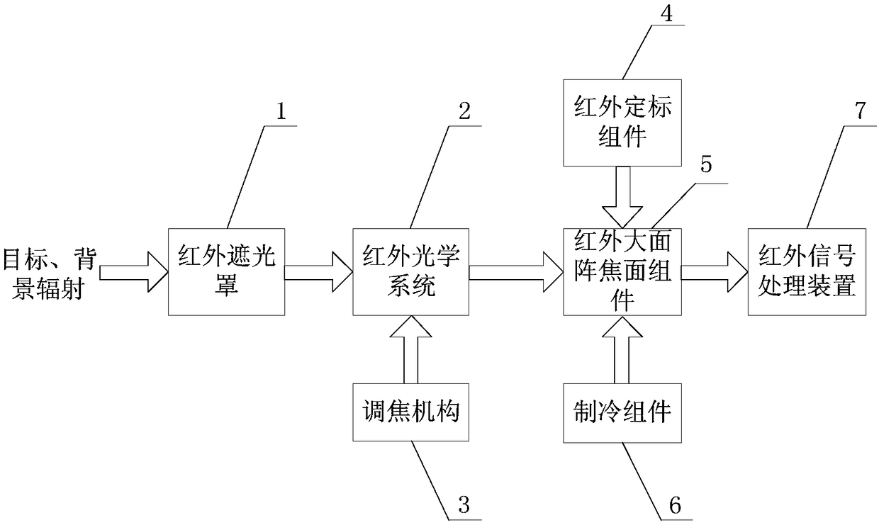
[0028] Such as figure 1 As shown, the spherical geostationary orbit high-resolution infrared area array staring camera system according to the present invention includes a geostationary orbit infrared light shield 1, a geostationary orbit infrared optical system 2, a focusing mechanism 3, a geostationary orbit infrared calibration assembly 4, Geostationary orbit infrared large array focal plane assembly 5, cooling assembly 6, geostationary orbit infrared signal processing device 7.

[0029] The geostationary orbit infrared light shield 1 is set on the geostationary orbit infrared optical system 2;

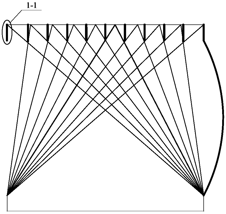
[0030] Such as figure 2 As shown, the inner wall of the infrared light shield 1 is provided with a light blocking ring 1-1;

[0031] The focusing mechanism 3 is connected with the geostationary orbit infrared optical system 2;

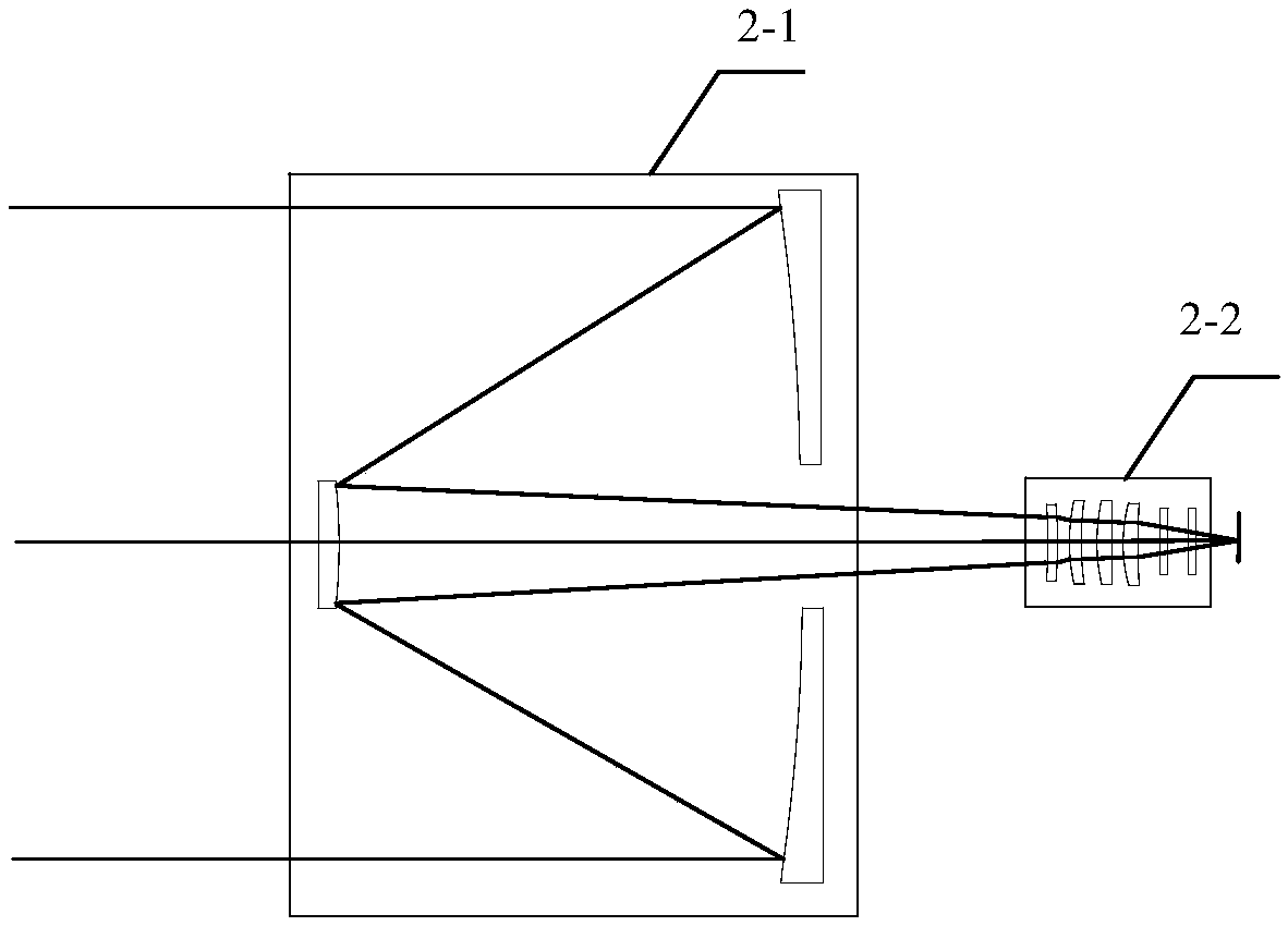
[0032] The optical path diagram of the ...


PUM


Abstract

The invention discloses a geostationary orbit high-resolution infrared area staring camera system, comprising: a geostationary orbit infrared shading cover, a geostationary orbit infrared optical system, a focusing mechanism, an earth orbit infrared calibration component, a geostationary orbit infrared Large area array focal plane assembly, refrigeration assembly, geostationary orbit infrared signal processing device; among them, the infrared optical system collects the radiation signal of ground objects in the detection area, and the focusing mechanism makes the geostationary orbit infrared optical system output the corrected ground object radiation signal , the geostationary orbit infrared large array focal plane component samples the corrected ground object radiation signal and converts it into an electrical signal, which is input to the geostationary orbit infrared signal processing device, and the geostationary orbit infrared signal processing device amplifies and filters the electrical signal And the ground object image signal is obtained after encoding. The invention solves the difficult problem that the existing cameras cannot balance high temporal resolution and high spatial resolution.

Description

technical field [0001] The invention belongs to the technical field of aerospace optics remote sensing, in particular to a geostationary orbit high-resolution infrared array staring camera system. Background technique [0002] Geostationary orbit high-resolution detection technology has become an important aspect of the future development of earth observation technology at home and abroad because of its orbital characteristics, such as large detection range, long-term detection of hotspot areas, and all-day high-resolution real-time monitoring and detection. direction. [0003] High-resolution Low-Earth Orbit (LEO) infrared optical imaging remote sensing satellites have been widely used for many years, but with low temporal resolution. Geostationary orbit (GEO) meteorological satellites have higher temporal resolution and larger imaging swath, but lower spatial resolution. In order to meet the requirements of earth observation that require high temporal resolution and rela...

Claims


Application Information

Patent Timeline
Patent Type & Authority Patents(China)
IPC IPC(8): G01J5/00G01J5/28G01J5/52G01J5/08H04N5/225H04N5/33
CPCH04N5/33G01J5/0066G01J5/007G01J5/28G01J5/52G01J2005/283G01J2005/0077G01J5/80G01J5/07G01J5/53H04N23/55
Inventor 于登云马文坡练敏隆董杰王跃石志城晋利兵王戬许云飞
Owner BEIJING RES INST OF SPATIAL MECHANICAL & ELECTRICAL TECH
Features
  • R&D
  • Intellectual Property
  • Life Sciences
  • Materials
  • Tech Scout
  • Unparalleled Data Quality
  • Higher Quality Content
  • 60% Fewer Hallucinations
Learn More