Method for improving simulation precision of high-altitude drainage basin hydrological process without data

A process simulation, high-altitude technology, applied in special data processing applications, instruments, climate change adaptation, etc., can solve the problems of direct hydrological simulation and flood forecasting, poor simulation accuracy of distributed hydrological models, and lack of localization of watershed model parameters and other issues, to achieve the effect of improving the suitability of the site, the method is simple, and the applicability is wide

Active Publication Date: 2017-11-07
XINJIANG INST OF ECOLOGY & GEOGRAPHY CHINESE ACAD OF SCI
View PDF10 Cites 12 Cited by
  • Summary
  • Abstract
  • Description
  • Claims
  • Application Information

AI Technical Summary

Problems solved by technology

These methods only consider the distance, terrain, vegetation coverage and other similarities between watersheds in mountainous areas, and they are directly applied to watersheds in high-altitude mountainous areas without data, which makes the simulation accuracy of the distributed hydrological model (SWAT) relatively low. Poor, cannot be directly used for hydrological simulation and flood forecasting
Due to the complex topography of high-altitude mountainous areas, even two adjacent watersheds are quite different due to various factors such as watershed area size, altitude difference, and land cover. , precipitation, etc.), vegetation and other related parameter factors, and directly transfer the parameters to the distributed hydrological model (SWAT) of high-altitude watersheds without data, which will make the parameters of the watershed model lack localization because of the uncertainty of parameters The error of the hydrological process simulation is too large, which often provides wrong information for the local hydrological simulation forecast

Method used


Image

  • Method for improving simulation precision of high-altitude drainage basin hydrological process without data

Examples


Embodiment 1

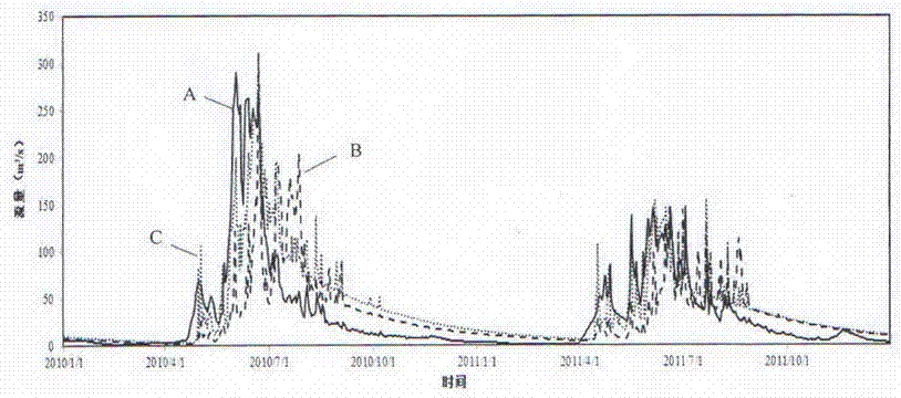
[0018] A method for improving the simulation accuracy of hydrological processes in high-altitude watersheds without data described in the present invention is based on the theoretical basis that the adjacent watersheds of the same mountain range have similar hydrophysical processes and horizontal and vertical regional differentiation laws, and can reduce the uncertainty of model parameters. Under the premise of reliability, the hydrological process simulation of high-altitude watersheds without measured meteorological and runoff data is realized. The specific operation is carried out according to the following steps:

[0019] a. The basic data such as digital elevation model, soil, land use / cover and other basic data required for building a distributed hydrological model (SWAT) for all target watersheds and participating watersheds with discharge measuring stations in the target area are given unified geographical coordinates and Projection, to ensure that it is in the same cla...


PUM


Abstract

The invention discloses a method for improving simulation precision of a high-altitude drainage basin hydrological process without data. The main purpose is to provide a method for improving simulation precision of a high-altitude drainage basin hydrological process without data. According to the method, a hydrological physical process, a neighboring area law and a vertical differentiation law are used as basic theory bases, and a parameter transfer relation is built for multiple groups of soil and water assessment tool (SWAT) parameters adjacent to a station mountain drainage basin in Xinjiang; based on the parameter transfer relation, a tool parameter set of a reference basin is converted into a tool parameter set of a target drainage basin, so that high-precision simulation of the high-altitude drainage basin hydrological process without data is achieved. The method is applicable to hydrological process simulation of medium and small rivers of a high-altitude region without data; after localization of tool parameters is achieved, the simulation precision of the drainage basin hydrological process without data can be improved, the method is beneficial to monitoring and early warning of a mountain torrent, and the risk of the mountain torrent disaster is reduced.

Description

technical field [0001] The invention relates to a method for improving the simulation accuracy of hydrological processes in high-altitude watersheds without data, in particular to a method for improving the simulation accuracy of hydrological processes in high-altitude watersheds without measured runoff data. Background technique [0002] Mountainous areas are widely distributed around the world. There are about 7,200 square kilometers of glaciers and snow-covered areas in high-altitude areas. About 1 / 3 of the world's people live near mountainous areas. These areas are also prone to disasters such as landslides, mudslides, and mountain torrents. These areas Disaster is no longer a purely natural phenomenon, but has a significant impact on society and economy. The total area of ​​my country's high-altitude mountainous areas accounts for about 2 / 3 of the country's total area, of which the total area distributed in arid and semi-arid areas amounts to more than 2 million square ...

Claims


Application Information

Patent Timeline
Patent Type & Authority Applications(China)
IPC IPC(8): G06F17/30
CPCG06F16/29Y02A10/40
Inventor 刘铁孟凡浩陈曦黄粤包安明刘蛟罗敏段永超田霖
Owner XINJIANG INST OF ECOLOGY & GEOGRAPHY CHINESE ACAD OF SCI
Why Eureka
Try Eureka