Real-time monitoring system and method of intelligent visual three-dimensional geological sliding and collapsing

A real-time monitoring system, 3D geological technology, applied in image data processing, instrumentation, 3D modeling, etc., can solve problems such as high risk and traditional backwardness, achieve low data volume, high accuracy, low cost and power consumption Effect

Pending Publication Date: 2017-11-07
ZHANGZHOU EASTERN INTELLIGENT METER
View PDF5 Cites 2 Cited by
  • Summary
  • Abstract
  • Description
  • Claims
  • Application Information

AI Technical Summary

Problems solved by technology

In order to solve these problems, most of the reinforcement methods are used to build concrete retaining walls, stone fences, and dispatch commissioners on houses or road slopes. This method is traditionally backward and dangerous. Therefore, the inventor focuses on the second, and through theory and Field verification, designing a real-time monitoring system and method for three-dimensional geological sliding and collapse with intelligent vision, and this case was born from this

Method used


Image

  • Real-time monitoring system and method of intelligent visual three-dimensional geological sliding and collapsing
  • Real-time monitoring system and method of intelligent visual three-dimensional geological sliding and collapsing
  • Real-time monitoring system and method of intelligent visual three-dimensional geological sliding and collapsing

Examples


Embodiment Construction

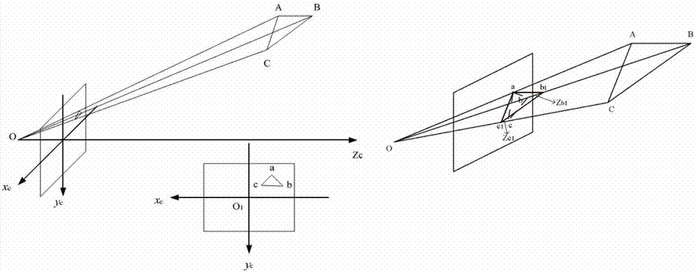
[0043] see Figure 1 to Figure 5 , to further elaborate on the preferred embodiments of the present invention.

[0044] In the present invention, a set of non-contact intelligent image geological sliding and collapse monitoring system is developed, not by image recognition technology, but by comparing images obtained before and after to quickly calculate the geological sliding displacement.

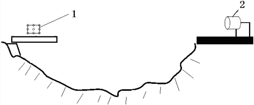
[0045] The main equipment involved in the system includes a calibration board 1 , a camera 2 , and a remote terminal 3 . The LED light spots are arranged on the calibration board 1 . In this embodiment, 9 spots are taken as an example, arranged in a matrix of 3 rows and 3 columns. The calibration plate 1 is set in the monitoring area, that is, the moving point area where displacement may occur. Set up a camera 2 at a stable site near the monitoring area. The camera 2 is equipped with a MCU (Micro Control Unit, Micro Control Unit). After the data extracted from the camera 2 is calculated...


PUM


Abstract

The invention relates to a real-time monitoring system and method of intelligent visual three-dimensional geological sliding and collapsing. A luminescent calibration plate is set in the monitoring area for long-distance projection, a camera with an MCU module is set up in a stable field and the camera completes image extraction of three light spots in long-distance projection. The displacement changes of the three light spots are monitored, the MCU operation is performed, and an RS485 and a Zigbee transmission interface are used to return a monitoring result to a remote terminal. The invention only needs a single camera module and three right-angled LED calibration points, and does not need image recognition. Only the images obtained before and after can be compared to calculate the displacement of the three-dimensional geological slide, which greatly simplifies the computational complexity. Therefore, the use of a high-speed microcomputer or a DSP chip is not required, the system architecture is simple, and the cost and the power consumption are low.

Description

technical field [0001] The invention relates to the technical field of geological monitoring, in particular to an intelligent vision three-dimensional geological sliding and collapse real-time monitoring system and method thereof. Background technique [0002] The past 10 years have been one of the most severe periods of natural disasters since the founding of New China. Major disasters such as the Wenchuan earthquake, the Yushu earthquake, and the Zhouqu torrent and debris flow have occurred one after another. Severe floods, droughts, geological disasters, and typhoons have frequently occurred concurrently. have a serious impact on economic and social development. Especially in August this year, a huge landslide in Shanyang, Shaanxi caused dozens of missing people and heavy property losses, which was a shocking tragedy. [0003] The World Bank estimates that half of the world's population is exposed to the threat of natural disasters, and my country is also one of the coun...

Claims


Application Information

Patent Timeline
Patent Type & Authority Applications(China)
IPC IPC(8): G06T7/00G06T17/00
CPCG06T7/0004G06T17/00
Inventor 陈志宏陈添丁过思甸林添成黄成李晗何建顺
Owner ZHANGZHOU EASTERN INTELLIGENT METER
Why Eureka
Try Eureka