Topographical data-based test method of suspicious numerical values of telemetering rainfall amount sites

A technology of terrain data and numerical inspection, applied in structured data retrieval, relational database, database model, etc., to achieve the effect of improving accuracy and precision

Active Publication Date: 2017-11-28
邱超
View PDF2 Cites 6 Cited by
  • Summary
  • Abstract
  • Description
  • Claims
  • Application Information

AI Technical Summary

Problems solved by technology

[0003] The purpose of the present invention is to solve the problems existing in the existing rainfall verification, improve the previous data verification method ...

Method used


Image

  • Topographical data-based test method of suspicious numerical values of telemetering rainfall amount sites
  • Topographical data-based test method of suspicious numerical values of telemetering rainfall amount sites
  • Topographical data-based test method of suspicious numerical values of telemetering rainfall amount sites

Examples


Embodiment Construction

[0032] The present invention will be further described below in conjunction with accompanying drawings and specific implementation benefits.

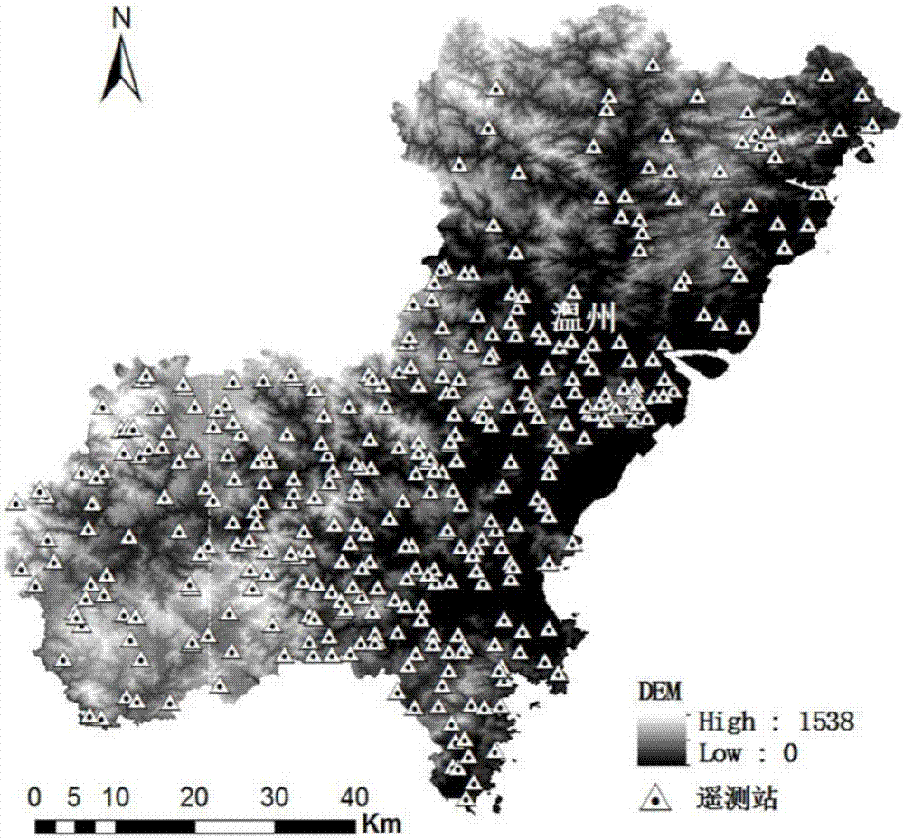
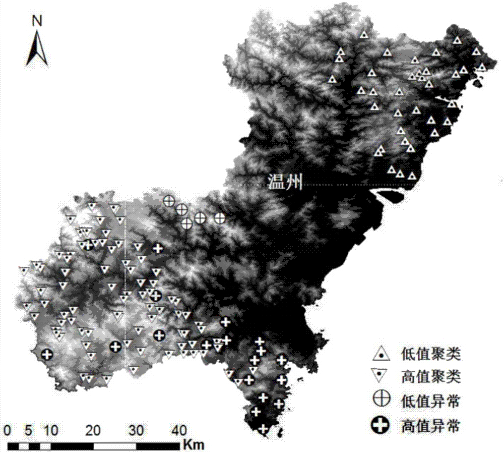
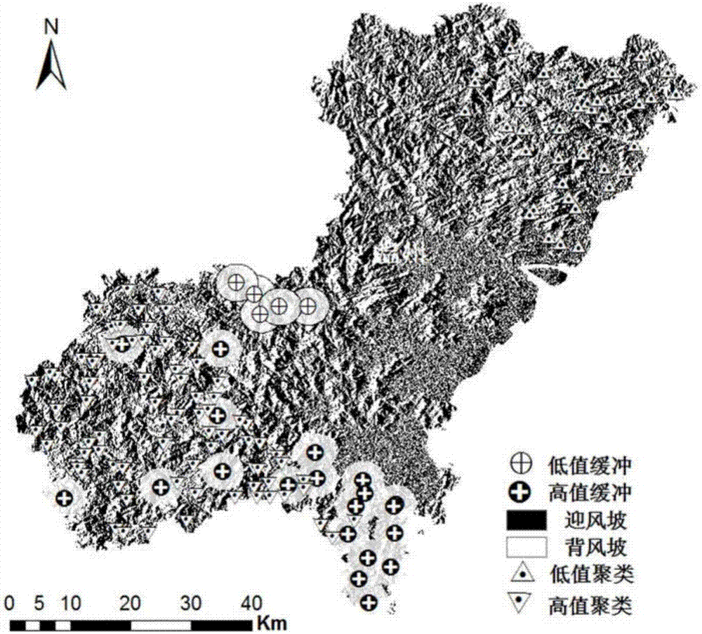
[0033] The present invention first establishes the spatial weight matrix according to the geographic space coordinate distance of the real-time rainfall station data in the region; then carries out the spatial autocorrelation modeling analysis on each station according to the rainfall attribute value of the station, and judges whether the attribute value is Clustering; secondly, on the basis of clustering, by calculating the clustering state discrimination index S cdi Screen out suspicious values; finally, reclassify the stations according to the digital elevation attributes of the telemetry rainfall stations, and conduct spatial similarity analysis on the attribute values ​​of the suspicious stations and the stations within the set distance threshold range, so as to confirm the telemetry rainfall stations Whether the incoming data is a...


PUM


Abstract

The invention discloses a topographical data-based test method of suspicious numerical values of telemetering rainfall amount sites. According to the method, real-time rainfall amount site data in a region is used to establish a spatial weight matrix according to geospatial coordinate distances; spatial autocorrelation modeling analysis is carried out on each site according to a rainfall attribute value of the site, and whether the attribute value clusters is judged according to clustering statistic parameters; the suspicious numerical value is screened out through calculating a clustering state discriminant index Scdi on the basis of clustering; and site re-classification is carried out according to digital elevation attributes of the telemetering rainfall amount sites, spatial similarity analysis is carried out on the attribute values of the suspicious sites and the sites in a set distance threshold value range, and thus whether the data sent from the telemetering rainfall amount sites is abnormal values is confirmed. The method improves the accuracy and the precision of traditional single threshold value verification.

Description

technical field [0001] The invention relates to a numerical verification algorithm, in particular to a method for verifying remote measurement data of rainfall stations based on the spatial relationship of continuous elements and slope aspect verification. Background technique [0002] Precipitation plays an important role in the fields of hydrology, meteorology, ecology, and agricultural research. Especially with the advent of the era of big data, rainfall data has important basic significance in disaster prediction, flood control and early warning. At the same time, as an important environmental element, precipitation is also a research hotspot in the field of natural science; therefore, the accuracy and precision of rainfall must be effectively verified. Surface rainfall telemetering station is a widely used precipitation measurement method, and it is also the main method of rainfall data collection in hydrological application departments. However, due to the failure, da...

Claims


Application Information

Patent Timeline
IPC IPC(8): G06F17/30G06F17/17
CPCG06F16/285G06F17/17Y02A90/10
Inventor 邱超吴宏海王威
Owner 邱超
Why Eureka
Try Eureka