Method for establishing seismic survey and observation system with high reliability
An observation system and seismic exploration technology, applied in the field of oil and gas seismic exploration, can solve the problems of incompatibility with the actual situation of underground strata, low efficiency of numerical simulation, failure to consider the absorption and attenuation of the medium, etc.
- Summary
- Abstract
- Description
- Claims
- Application Information
AI Technical Summary
Problems solved by technology
Method used
Image
Examples
Embodiment 1
[0070] Embodiment 1: Establishment of a 3D land seismic exploration observation system for a block in Shengli Oilfield.
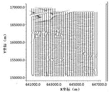
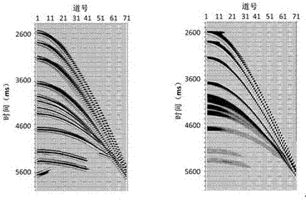
[0071] in, figure 2 It is a schematic diagram of a three-dimensional layered geological model established and used; in this model, the formation velocity and quality factor of each layer are constant, and the quality factor is automatically calculated according to the empirical formula between velocity and quality factor. image 3 Schematic diagram of the seismic exploration observation system designed for . Among them, keeping other observation system parameters unchanged, only changing the track spacing, three alternative seismic exploration observation systems with track spacing of 25m, 12.5m, and 10m were designed respectively. Figure 4 In order to use the conventional Gaussian beam method ( Figure 4 left part) and the numerical simulation method in the present invention ( Figure 4 Right part) comparison results of single-shot records obtained by...
Embodiment 2
[0073] Embodiment 2: The establishment of a three-dimensional land seismic exploration and observation system for a block in Shengli Oilfield.
[0074] in, Figure 7 Schematic diagram of the vertical slice of the established 3D layered geological model; in this model, the formation velocity and quality factor of each layer are constant, and the quality factor is automatically calculated according to the empirical formula between velocity and quality factor. On the basis of the theoretical observation system design, the observation system is adjusted in combination with the surface conditions of the work area, and the following results are obtained: Figure 8 Schematic diagram of the seismic exploration observation system of the design shown.
[0075] In order to determine the imaging effect of the target layer of the designed seismic exploration observation system, the numerical simulation method in the present invention is used to carry out forward modeling, and the followin...
PUM
 Abstract
Description
Claims
Application Information
 - R&D
- Intellectual Property
- Life Sciences
- Materials
- Tech Scout
- Unparalleled Data Quality
- Higher Quality Content
- 60% Fewer Hallucinations
Browse by: Latest US Patents, China's latest patents, Technical Efficacy Thesaurus, Application Domain, Technology Topic, Popular Technical Reports.
© 2025 PatSnap. All rights reserved.Legal|Privacy policy|Modern Slavery Act Transparency Statement|Sitemap|About US| Contact US: help@patsnap.com


