A satellite attitude error correction method and device based on laser altimetry data

A satellite attitude and error correction technology, applied in the field of satellite surveying and mapping, can solve problems such as high cost and difficulty in meeting the needs of surveying and mapping with elevation measurement accuracy

Active Publication Date: 2020-01-03
SATELLITE SURVEYING & MAPPING APPL CENTSASMAC NAT ADMINISTATION OF SURVEYING MAPPING & GEOINFORMATION OF CHINANASG
View PDF4 Cites 0 Cited by
  • Summary
  • Abstract
  • Description
  • Claims
  • Application Information

AI Technical Summary

Problems solved by technology

[0006] In view of this, the embodiment of the present invention provides a satellite attitude error correction method and equipment based on laser altimetry data to solve the problem of the high cost of the satellite attitude angle error correction method in the prior art and the lack of height measurement of ground control points The accuracy is difficult to meet the needs of surveying and mapping

Method used


Image

  • A satellite attitude error correction method and device based on laser altimetry data
  • A satellite attitude error correction method and device based on laser altimetry data
  • A satellite attitude error correction method and device based on laser altimetry data

Examples


Embodiment 1

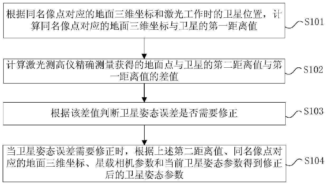
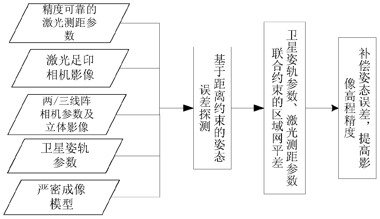
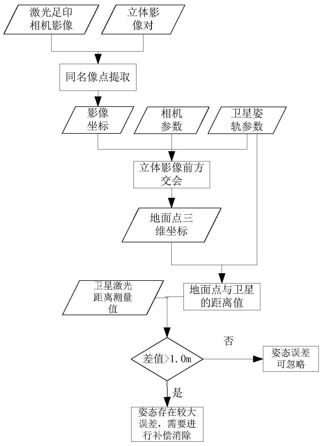
[0043] In this embodiment, a satellite attitude error correction method based on laser altimetry data is provided, figure 1 It is a flowchart of a satellite attitude error correction method based on laser altimetry data according to an embodiment of the present invention, as figure 1 As shown, the method includes the following steps:

[0044] S101: According to the ground three-dimensional coordinates corresponding to the image point with the same name and the satellite position when the laser is working, calculate the first distance value between the ground three-dimensional coordinates corresponding to the image point with the same name and the satellite; specifically, according to the laser footprint image and the stereo image pair, obtain The coordinates of the same-named image point of the stereoscopic image corresponding to the laser footprint point, according to the rigorous geometric positioning model of the satellite image and the coordinates of the same-named image p...

Embodiment 2

[0137] Figure 7 It is a schematic diagram of the hardware structure of the computer equipment of the satellite attitude error correction method based on laser altimetry data according to an embodiment of the present invention, as Figure 7 As shown, the device includes one or more processors 710 and memory 720, Figure 7 A processor 710 is taken as an example.

[0138] The device for executing the satellite attitude error correction method based on laser altimetry data may further include: an input device 730 and an output device 740 .

[0139] Processor 710, memory 720, input device 730, and output device 740 may be connected by bus or other means, Figure 7 Take connection via bus as an example.

[0140] The processor 710 may be a central processing unit (Central Processing Unit, CPU). The processor 710 may also be other general-purpose processors, digital signal processors (Digital Signal Processor, DSP), application-specific integrated circuits (Application Specific I...

Embodiment 3

[0147] The embodiment of the present invention also provides a computer-readable storage medium, the computer-executable instruction is stored in the computer-executable instruction, and the computer-executable instruction can execute the satellite attitude error based on laser altimetry data in any of the above-mentioned method embodiments Correction method. Wherein, the storage medium may be a magnetic disk, an optical disk, a read-only memory (Read-Only Memory, ROM), a random access memory (Random Access Memory, RAM), a flash memory (FlashMemory), a hard disk (Hard Disk Drive, abbreviation: HDD) or a solid-state drive (Solid-State Drive, SSD), etc.; the storage medium may also include a combination of the above-mentioned types of memory.

[0148] Those skilled in the art should understand that the embodiments of the present invention may be provided as methods, systems, or computer program products. Accordingly, the present invention can take the form of an entirely hardwa...


PUM


Abstract

The invention provides a satellite attitude error correction method and a satellite attitude error correction device based on laser altitude measurement data. The method includes the steps of: 1) calculating a first distance value between a ground three-dimensional coordinate being corresponded to a corresponding image point and a satellite; 2) calculating the difference between a second distance value and the first distance value, wherein the second distance value is the distance, which is accurately measured by a satellite laser altitude measurement instrument, between a ground point and the satellite; 3) according to the difference, determining whether the satellite attitude error needs to be corrected or not; 4) if the satellite attitude error needs to be corrected, calculating corrected satellite attitude parameters according to the second distance value, the ground three-dimensional coordinate being corresponded to a corresponding image point, satellite-borne camera parameters, and present satellite attitude parameters. The satellite attitude error correction method is based on the laser altitude measurement data, wherein high-precision distance measuring information is acquired by means of the laser altitude meter supported on the same platform of the satellite, thereby detecting and effectively correcting the attitude angle measurement error of the satellite. The method and device can improve the height accuracy of a satellite image without ground control, effectively solve a difficult problem of high-precision mapping for overseas regions, and save cost.

Description

technical field [0001] The invention relates to the technical field of satellite surveying and mapping, in particular to a satellite attitude error correction method and equipment based on laser altimetry data. Background technique [0002] Satellite photogrammetry and laser altimeter are two important technologies for satellite earth observation to obtain three-dimensional surface information. Among them, satellite photogrammetry is a general-purpose advanced technology used for topographic map surveying and mapping in various countries in the world. Especially in recent years, with the development of technologies such as three-line array cameras, the acquisition technology of 3D remote sensing information has made great progress. [0003] Satellite laser altimetry has the ability to actively obtain three-dimensional information on the global surface and targets, and can provide services for quickly obtaining three-dimensional control points and three-dimensional mapping in...

Claims


Application Information

Patent Timeline
Patent Type & Authority Patents(China)
IPC IPC(8): G01C25/00
CPCG01C25/00
Inventor 李国元唐新明高小明樊文锋陈继溢薛玉彩谢俊峰
Owner SATELLITE SURVEYING & MAPPING APPL CENTSASMAC NAT ADMINISTATION OF SURVEYING MAPPING & GEOINFORMATION OF CHINANASG
Why Eureka
Try Eureka