Method of Extracting Urban Building Height Based on Multi-temporal Remote Sensing Image Shadow

A technology of building height and remote sensing images, applied in image analysis, image enhancement, 3D modeling, etc. The effect of precision

Inactive Publication Date: 2020-06-02
ZHENGZHOU UNIV
View PDF3 Cites 1 Cited by
  • Summary
  • Abstract
  • Description
  • Claims
  • Application Information

AI Technical Summary

Problems solved by technology

These methods have the advantages of high efficiency, fast speed, and convenience, but they also have the disadvantage of being greatly affected by time and space limitations.

Method used


Image

  • Method of Extracting Urban Building Height Based on Multi-temporal Remote Sensing Image Shadow
  • Method of Extracting Urban Building Height Based on Multi-temporal Remote Sensing Image Shadow
  • Method of Extracting Urban Building Height Based on Multi-temporal Remote Sensing Image Shadow

Examples


Embodiment Construction

[0052] The specific embodiments of the present invention will be described in detail below in conjunction with the accompanying drawings.
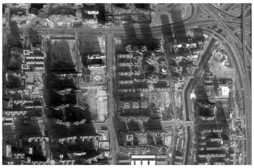
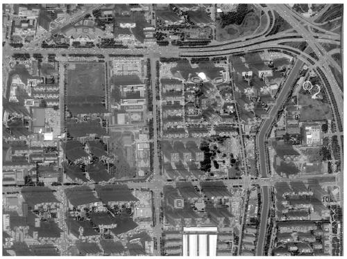
[0053] The research area of ​​the present invention selects part of Jinshui District, Zhengzhou City, and the data are WorldView-2 image data in 2015 and 2016, and each step is processed by combining ENVI5.1 and Arcgis10.2 software. Combine now Figure 1 to Figure 11 As shown, the method for quickly constructing a 3D model of a building based on multi-temporal remote sensing image shadows includes the following steps:

[0054] Step 1: Obtain the original high-resolution remote sensing images containing the target area, and perform preprocessing processes such as cropping, radiometric calibration, atmospheric correction, and band fusion to obtain the images of the target area in 2015 and 2016.

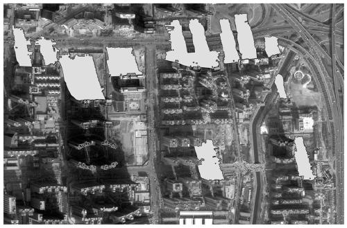
[0055] Step 2: Combining the method of image classification and empirical knowledge, after selecting a suitable sample in the training area, selec...


PUM


Abstract

Based on the method of extracting the height information of urban buildings based on the shadows of multi-temporal remote sensing images, the present invention aims to form a systematic, fast and accurate method, using two remote sensing images of different time phases (the two images have different sun elevation angles and satellite azimuths) Angle), to analyze and calculate the shadow of the target building in batches, and then realize the rapid and accurate extraction of the height of the target building in the area, which will help to improve the efficiency of measurement, 3D modeling and other work; the specific implementation is mainly through calculation The length of the building shadow, combined with the angle relationship between the landmark building and its shadow on the image, selects the corresponding mathematical model to calculate the height value of the target building in the area; the two sets of building height results calculated by using two remote sensing images are used to construct a simulation model based on the least squares method. Combine the equations to obtain the corrected height of the target building, thereby improving the accuracy of the calculation results.

Description

technical field [0001] The invention relates to the technical fields of remote sensing image processing, mathematical model design and three-dimensional structure, in particular to a method for extracting urban building height information based on multi-temporal remote sensing image shadows. Background technique [0002] With the development of the times, the speed of urbanization expansion in my country is getting faster and faster. Urban expansion includes two aspects of urban horizontal space expansion and vertical space expansion: horizontal space expansion is manifested as a sharp increase in the built-up area; vertical space is mainly manifested as The increase in the height of urban buildings, and the expansion of the vertical height of the city, on the one hand, relieves the pressure brought about by the expansion of horizontal space, and on the other hand, it can form a compact urban spatial form, which is convenient for the deployment of urban planning, resource allo...

Claims


Application Information

Patent Timeline
Patent Type & Authority Patents(China)
IPC IPC(8): G06K9/00G06K9/62G06T7/60G06T7/62G06T17/05
CPCG06T7/60G06T17/05G06T2207/10032G06V20/176G06F18/23G06F18/2135G06F18/2411
Inventor 杨海波王宗敏毛鹏磊
Owner ZHENGZHOU UNIV
Why Eureka
Try Eureka