Aerial photography image calibration method for unmanned aerial vehicle suitable for plane measurement

An image calibration and plane measurement technology, applied in image enhancement, image analysis, image data processing, etc., can solve the problems of inability to obtain calibration results in real time, complex implementation process, and high technical requirements, and achieve real-time UAV calibration. And the effect of measurement, clear process and high calibration accuracy

Active Publication Date: 2018-03-09
成都准望科技有限公司
View PDF5 Cites 7 Cited by
  • Summary
  • Abstract
  • Description
  • Claims
  • Application Information

AI Technical Summary

Problems solved by technology

Although this method is applicable to any aerial pictures, it needs to provide the geographical coordinates of known points, and even use GPS locator to measure the known points on the spot to obtain the geographical coordinates, resulting in complicated implementation process, low efficiency, high technical requirements, and user poor experience
[0006] 2. Through professional image measurement software, several continuous associated images are geographically spliced ​​according to the aerial three-dimensional data of exposure

Method used


Image

  • Aerial photography image calibration method for unmanned aerial vehicle suitable for plane measurement
  • Aerial photography image calibration method for unmanned aerial vehicle suitable for plane measurement
  • Aerial photography image calibration method for unmanned aerial vehicle suitable for plane measurement

Examples


Embodiment 1

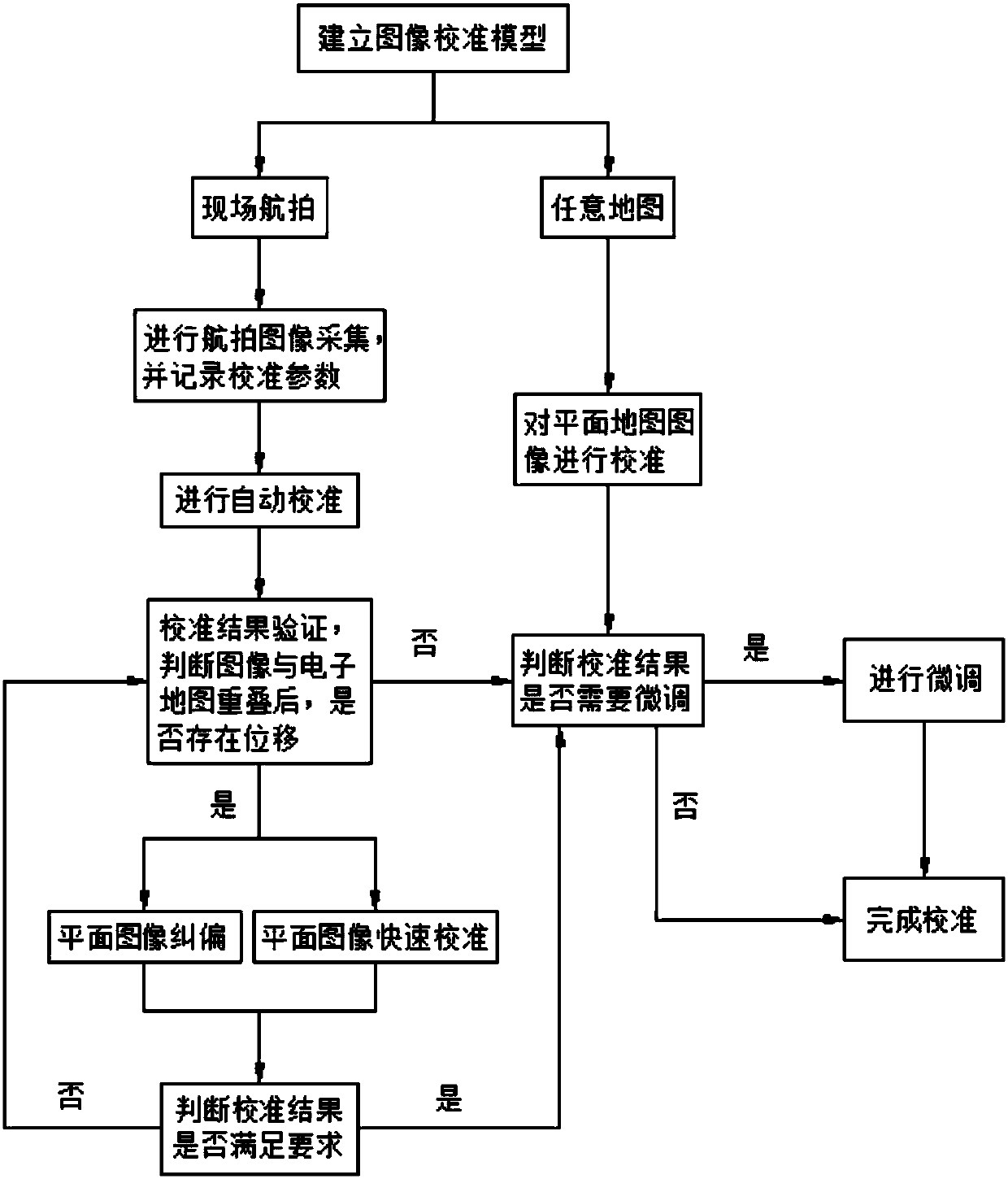
[0122] Such as figure 1 As shown, a UAV aerial image calibration method suitable for plane measurement includes the following steps:

[0123] a. Establish an image calibration model using three parameters: image azimuth Azimuth, image scale Scale, and image origin Origin;

[0124] b. Calibrate the planar map image or conduct on-the-spot acquisition and self-calibration of the planar map to obtain preliminary calibration results;

[0125] c. If the preliminary calibration result is the result of calibrating the planar map image, proceed to step f; if the preliminary calibration result is the result of field collection and self-calibration of the planar map, proceed to step d;

[0126] d. Verify the calibration results of the preliminary calibration results. By superimposing the calibrated images on the electronic map, check the overlapping effect. If it is completely or basically overlapped or meets the surveying and mapping requirements, go to step f; if there is displacement...

Embodiment 2

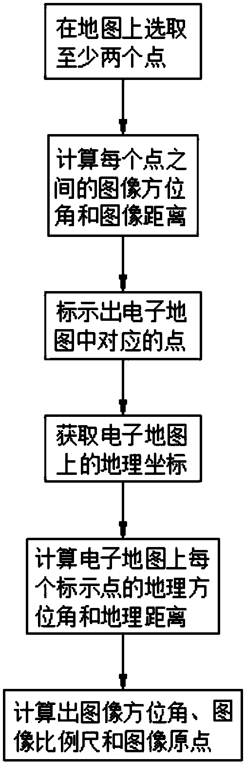
[0152] This embodiment is on the basis of embodiment 1, as figure 2 As shown, the specific steps for calibrating the plane map image in the step b are as follows:

[0153] b1. Select at least two image points on the planar map;

[0154] b2. Calculate the image azimuth picAzimuth and the image distance picDistance between two adjacent image points;

[0155] b3. Mark the corresponding marked points in the electronic map according to the selection order of the image points, and obtain the geographical coordinates of the marked points on the electronic map during the marking process, and pair them with the corresponding image points;

[0156] b4. Calculate the geographic azimuth MapAzimuth and the geographic distance MapDistance between adjacent marked points on the electronic map;

[0157] b5. Calculate the image azimuth Azimuth, the image scale Scale, and the image origin according to the acquired image azimuth picAzimuth, image distance picDistance, geographic azimuth MapAzi...

Embodiment 3

[0160] In this embodiment, on the basis of Embodiment 2, in the step b5, the image azimuth angle Azimuth, the image scale Scale and the image origin are calculated in the following manner, wherein:

[0161] Image azimuth Azimuth: Azimuth=MapAzimuth-picAzimuth;

[0162] Image scale Scale: Scale=MapDistance÷picDistance;

[0163] Image Origin: Calculate the image coordinates of Origin according to the image size of the planar map, and obtain a marked point A and the geographic coordinates of A; the image azimuth from A to Origin is added to Azimuth to get the geographic azimuth rotation from A to Origin, A Multiply the image distance to Origin by Scale to get the geographic distance length from A to Origin, and use the length, rotaion, and geographic coordinates of A to get the geographic plane coordinates of Origin through the geographic coordinate conversion method. So far, according to the calibration model that has been calibrated, the geographic coordinates of each image po...


PUM


Abstract

The invention discloses an aerial photography image calibration method for an unmanned aerial vehicle suitable for plane measurement. According to the method, firstly, an image calibration model is built, and whether any map is subjected to calibration or on-site aerial photography calibration is judged. If any map is judged to be subjected to calibration, the fine adjustment is carried out to complete calibration after the image calibration operation. If any any map is judged to be subjected to on-site aerial photography calibration, a photography image is collected and calibration parametersare recorded. After that, the automatically calibrating operation is carried out and preliminary calibration parameters are obtained. Meanwhile, whether primary calibration parameters meet the requirement or not is judged. If primary calibration parameters meet the requirement, the calibration is completed. If primary calibration parameters do not meet the requirement, the plane image correctionor the plane image fast calibration is carried out. After the plane image correction or the plane image fast calibration, the fine adjustment is carried out to complete calibration. The method is simpler, clearer and faster in imaging operation, so that the real-time unmanned aerial vehicle calibration and measurement can be achieved. The time cost is greatly saved. The fast calibration mode can be adopted, so that the map blind spot problem of image calibration can be compensated. The calibration efficiency and the user experience are greatly improved.

Description

technical field [0001] The invention relates to the field of image calibration, in particular to a method for calibrating aerial images of unmanned aerial vehicles suitable for plane measurement. Background technique [0002] Traditional surveying and mapping surveys mostly use professional surveying instruments such as GPS locators or total stations for field surveys. Although such surveying and mapping methods have high precision, they are difficult to operate and need to be on the spot to complete the survey work, which is inefficient. [0003] In recent years, with the development of unmanned aerial vehicle technology, more and more survey work has begun to integrate UAV aerial photography technology into it. With the mobility and intelligence of UAV, the measurement efficiency has been greatly improved. However, at present, the operation of UAV measurement technology still requires a professional team and equipment to carry out, which not only requires high technical re...

Claims


Application Information

Patent Timeline
IPC IPC(8): G06T5/00G06T7/33G01C11/04
CPCG01C11/04G06T5/006G06T2207/10032G06T2207/30181G06T7/337
Inventor 黄仁杰
Owner 成都准望科技有限公司
Why Eureka
Try Eureka