Method for observing water level variation based on signal to noise ratio data of Beidou navigation positioning system

A positioning system and Beidou navigation technology, applied in satellite radio beacon positioning system, radio wave measurement system, measurement device, etc., can solve the problems of high cost, difficult installation, time-consuming and laborious, etc., and achieve the effect that is conducive to development and application

Inactive Publication Date: 2018-03-13
CENT SOUTH UNIV
View PDF4 Cites 13 Cited by
  • Summary
  • Abstract
  • Description
  • Claims
  • Application Information

AI Technical Summary

Problems solved by technology

Traditionally, a water level gauge is generally used to observe the water level, which is divided into manual observation mode and automatic observation mode. The former is time-consuming, laborious and inefficient, while the latter has the advantages of high time resolution and high precision, but the cost is high and it is not easy to install.

Method used


Image

  • Method for observing water level variation based on signal to noise ratio data of Beidou navigation positioning system
  • Method for observing water level variation based on signal to noise ratio data of Beidou navigation positioning system
  • Method for observing water level variation based on signal to noise ratio data of Beidou navigation positioning system

Examples


Embodiment Construction

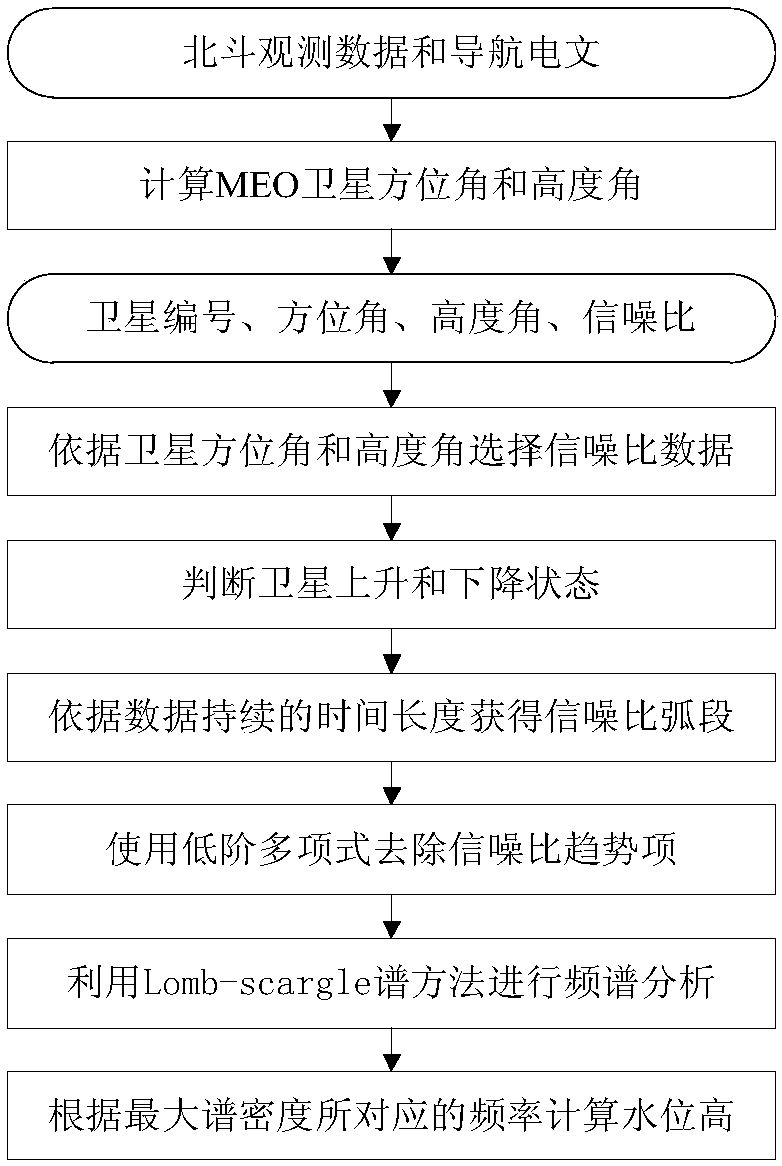
[0021] The method process of the present invention is as figure 1 As shown, it includes the following specific steps:

[0022] 1) In order to receive more reflected signals from the water surface, choose to install a Beidou / GNSS receiver facing the water area to obtain Beidou observation data and navigation messages;

[0023] 2) Select the MEO satellite, and calculate the satellite azimuth and altitude at different times according to the station coordinates and the navigation message of the Beidou system;

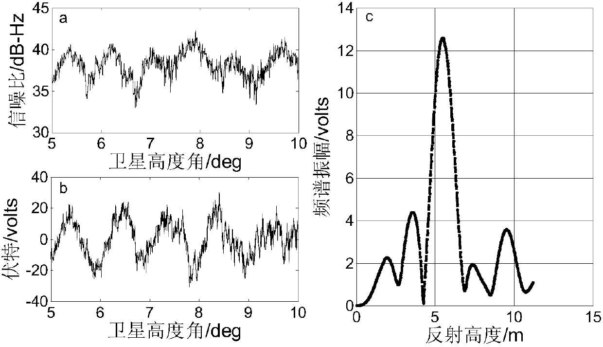
[0024] 3) According to the azimuth angle and altitude angle of the MEO satellite at different times, the signal-to-noise ratio data at the corresponding time is extracted from the observation data file of the Beidou navigation system;

[0025] 4) According to the water surface reflection environment of the station, the azimuth and altitude angle are used as threshold parameters, so that the intercepted SNR data is mainly affected by the reflection of the water surface, and...


PUM


Abstract

The invention discloses a method for observing water level variation based on signal to noise ratio data of a Beidou navigation positioning system. The method comprises: using a Beidou receiver to obtain observation data and navigation data; selecting a MEO satellite of the Beidou system, based on the navigation data and coordinates of an observation station, calculating an elevating angle and anazimuth angle of the satellite; based on observation data of the Beidou system, extracting signal to noise ratio data of the MEO satellite; according to a water surface reflection environment of the observation station, selecting data meeting conditions from the extracted signal to noise ratio data; according to rising and falling states of the satellite and time duration of the data, dividing thesignal to noise ratio data into arc segments; aimed at each piece of arc segment, removing a trend term of the data, and obtaining a signal to noise ratio residual sequence; using a Lomb-Scargle spectral method to analyze the detrended signal to noise ratio data; and according to frequency corresponding to maximum spectrum density, calculating water level. The invention provides a new method forobserving water level variations using the signal to noise ratio of a Beidou navigation positioning system, and a result consistent with a result of a conventional water level indicator is obtained.

Description

technical field [0001] The invention relates to a method for observing water level changes based on signal-to-noise ratio data of a Beidou navigation and positioning system. Background technique [0002] Water is one of the important disaster-causing factors of geological disasters, so the monitoring of water level changes is extremely important. Traditionally, water level gauges are generally used to observe the water level, which is divided into manual observation mode and automatic observation mode. The former is time-consuming, laborious and inefficient, while the latter has the advantages of high time resolution and high precision, but it is expensive and difficult to install. In recent years, with the development of GNSS-R technology, it has developed into a new technology for monitoring changes in the earth's environment. Some scholars have retrieved sea level height, snow depth, and soil moisture based on GPS signal-to-noise ratio observations, and achieved good num...

Claims


Application Information

Patent Timeline
Patent Type & Authority Applications(China)
IPC IPC(8): G01F23/284G01S19/14
CPCG01F23/284G01S19/14
Inventor 匡翠林刘凯
Owner CENT SOUTH UNIV
Why Eureka
Try Eureka