
Monitoring method for estuarine wetland exotic species

A technology for wetlands and monitoring areas, applied in measuring devices, material analysis through optical means, instruments, etc., can solve the problems of low spectral resolution, complex processing, geometric distortion and irregular radiation of UAV images, and achieve coverage Effects of large range, precision optimization, time and effort reduction

Active Publication Date: 2018-06-22
EAST CHINA SEA FISHERIES RES INST CHINESE ACAD OF FISHERY SCI
View PDF6 Cites 9 Cited by
  • Summary
  • Abstract
  • Description
  • Claims
  • Application Information

AI Technical Summary

Problems solved by technology

However, in terms of plant monitoring, relying solely on images acquired by drones for classification faces the disadvantages of low spectral resolution of drone images and the need for complex processing due to geometric distortion and irregular radiation.

Method used


Image

  • Monitoring method for estuarine wetland exotic species

Examples


Embodiment Construction

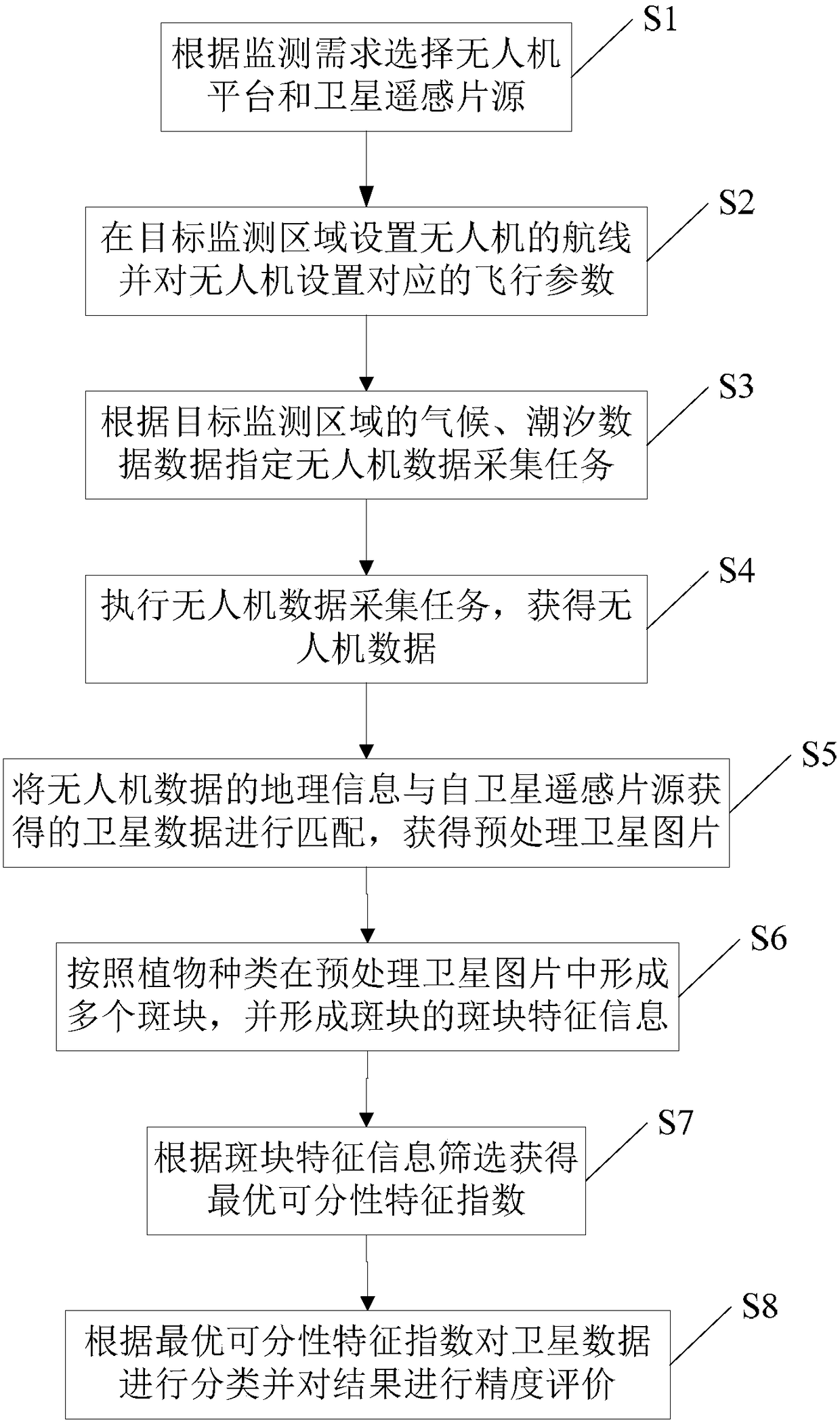
[0040] According to the attached figure 1 , Give the preferred embodiments of the present invention and describe them in detail, so as to better understand the functions and characteristics of the present invention.

[0041] See figure 1 , An estuary wetland alien species monitoring method according to an embodiment of the present invention includes the steps:

[0042] S1: Choose a UAV platform and a satellite remote sensing film source according to monitoring requirements.

[0043] In this example, DJI Corporation’s Phantom 3 drone was selected. This is a small, battery-powered, high-definition camera, and relatively inexpensive drone that can automatically set up route planning. Shooting angle, altitude, shooting interval and flight speed; the acquired photos integrate built-in GPS geographic information, which can be matched with satellite data without difference.

[0044] Satellite remote sensing image sources include Pleiades remote sensing high-resolution image sources, QuickB...


PUM


Abstract

The invention provides a monitoring method for estuarine wetland exotic species. The monitoring method comprises the following steps: S1, selecting an unmanned aerial vehicle and a satellite remote sensing film source according to a monitoring requirement; S2, setting a route of the unmanned aerial vehicle in a target monitoring area and setting corresponding flight parameters of the unmanned aerial vehicle; S3, setting an unmanned aerial vehicle data acquisition task; S4, executing the unmanned aerial vehicle data acquisition task to acquire unmanned aerial vehicle data; S5, matching geographic information of the unmanned aerial vehicle data and satellite data to acquire a pre-processed satellite picture; S6, extracting patch characteristic information in the pre-processed satellite picture; S7, screening to acquire optimal separable characteristic index according to the patch characteristic information; S8, classifying the satellite data according to the optimal separable characteristic index, and performing precision evaluation on a result. The invention provides the monitoring method for the estuarine wetland exotic species, which classifies vegetation of the exotic species byutilizing remote sensing software and geographic information system software, and has the advantages of high timeliness, high resolution, high accuracy, strong objectivity and low cost.

Description

Technical field [0001] The invention relates to the field of ecological environment assessment, in particular to a method for monitoring exotic species in estuary wetlands. Background technique [0002] Researching and monitoring the spatial characteristics and changes of coastal / estuarine wetland vegetation is a major tool to grasp the characteristics of the wetland ecological environment. It can provide protection for the biological protection of wetland ecosystems, evaluation of benthic environment quality, and ecological restoration of damaged habitats. Scientific basis and management recommendations. With the continuous deepening of globalization, biological invasion has caused the rapid loss of biodiversity in coastal / estuarine wetland ecosystems, and monitoring and management of the distribution of non-native plants requires urgent attention. However, it is far from being able to study the spatial distribution of invasive plants on a landscape scale only by relying on tra...

Claims


Application Information

Patent Timeline
IPC IPC(8): G01N21/17
CPCG01N21/17G01N2021/1797
Inventor 张婷婷赵峰王思凯高宇冯广朋张涛庄平
Owner EAST CHINA SEA FISHERIES RES INST CHINESE ACAD OF FISHERY SCI
Learn More